Maps of South Aegean Region
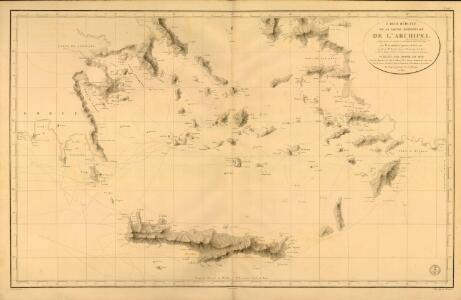
Carte réduite de la partie Méridionale de l’Archipel
Carte réduite de la partie Méridionale de l'Archipel, rédigée d'après les travaux exécutées dans les années 1818 & 1819 par M. Gauttier. [Paris] : Dépôt Général de la Marine
Carte De La Mer Mediterranee. XI.
Roux, Joseph
Graeciae pars Meridionalis.
1 : 1280000 L'Isle, Guillaume de, 1675-1726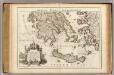
Graeciae pars Meridionalis.
1 : 1280000 L'Isle, Guillaume de, 1675-1726
GRAECIAE ANTIQUAE DESIGNATIO NOVA
Řecko Lotter, Tobias Conrad impensis T. Conr. Lotteri
Graeciae antiquae designatio nova
Řecko Lotter, Tobias Conrad impensis T. Conr. Lotteri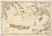
Mittelmeer
1 : 600000 Egejské moře Reichs-Marine-Amt
Das Ägäische Meer mit Kreta
1 : 1750000 Egejské moře (oblast) Carl Flemming
Grecian Archipelago, ancient.
1 : 1860000 Society for the Diffusion of Useful Knowledge (Great Britain)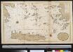
Het zuijderdeel van de Archipel Lagusche Eijlanden int groodt
Greece Gerard van Keulen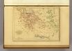
Grece et de l'Archipel.
1 : 2650000 Malte-Brun, Conrad, 1775-1826
[Die Balkan-Halbinsel, Blatt 4]
Adolf Stieler's Handatlas über alle Theile der Erde und über das Weltgebäude Stieler, Adolf Justus Perthes
Grecian archipelago
1 : 1840000 Egejské ostrovy (Řecko a Turecko) Smith, William Walker, C. Society for the diffusion of useful knowledge
Archipelagi Meridionalis seu Cycladum Insularum accurata Delineatio. [Karte], in: Novus atlas absolutissimus, Bd. 10, S. 234.
1 Karte aus Atlas Janssonius Offizin
Turkey
1 : 6170000 Kréta (Řecko) Walker, C. Baldwin & Cradock
Turkey III : containing the southern part of Greece and Candia
published under the superintendence of the Society for the Diffusion of Useful Knowledge engraved by J. & C. Walker London : Baldwin and Cradock
Iles de L'archipel; Dschezaïr
Nouvel atlas physique politique et historique de l'Empire ottoman et des états limitrophes en Europe, en Asie et en Afrique, en quarante feuilles Hellert, J.J. Bellizard, Dufour et Cie
Ancient Greece : southern part
1 : 1500000 published under the superintendence of the Society for the Diffusion of Useful Knowledge engraved by J. & C. Walker London : Baldwin and Cradock
L'Archipel.
1 : 1070000 Garnier, F. A., 1803-1863
Greece.
1 : 1470000 Mitchell, Samuel Augustus
Greece.
1 : 1470000 Mitchell, Samuel Augustus
CYCLADES | INSVLÆ | IN MARE ÆGÆO, | hodie | ARCHIPELAGO
Auctore | I. LAVRENBERGIO Amsterdami, J. Blaeu excudit
Greece.
1 : 1480000 Mitchell, Samuel Augustus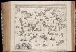
Archipelagi meridionalis, seu Cycladum insularum accurata delineatio / auctore I. Laurenbergio
1 : 650000 Annotatie: Kaart uitgegeven in de periode 1650-1662; Origineel is Blad 171 in atlas factice; Annotatie geografische gegevens: 4 schaalstokken: 8 Mill. Germ., en: 10 Mill. Gall., en: 30 Mill. Ital., en: 300 Stadia [S.l.] : [s.n.]
Insula Creta hodie Candia
1 : 900000 Kréta (Řecko) Homann, Johann Baptist Joh. Bapt. Homannus
Neueste Karte von Griechenland
Grosser Hand-Atlas über alle Theile der Erde in 170 Karten Meyer, J. Verlag des Bibliographischen Instituts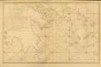
Carte des Côtes de la Grèce depuis Navarin en Morée
Carte des Côtes de la Grèce depuis Navarin en Morée, jusqu'au Cap Doro ... avec la partie de l'Archipel qu comprend les Îles Cyclades, dressée d'après les observations astronomiques et nautiques de M. de Chabert. [Paris] : Dépôt Général ... de la Marine
Insula Candia olim Creta. [Karte], in: Novus atlas absolutissimus, Bd. 9, S. 317.
1 Karte aus Atlas Janssonius Offizin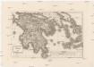
Peloponesus et Cyclades
1 : 710000 Kyklady (Řecko) Reichard, Christian Gottlieb Campius, D. a D. Campio