Maps of Crete

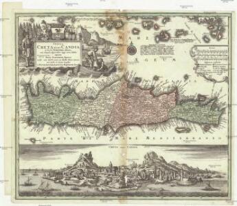
Insula Creta nunc Candia in sua 4 territoria distincta, cum aliquod adjacentibus AEgei maris insulis imprimis Nova Santorini insula modo ante 27 annos ex Abysso Maris emersa
1 : 930000 Kréta (Řecko) Seutter, Matthäus M. Seutter
Insula Creta nunc Candia
1 : 900000 Kréta (Řecko) Lotter, Tobias Conrad Tob. Conr. Lotter
Insula Candia olim Creta. [Karte], in: Novus atlas absolutissimus, Bd. 9, S. 317.
1 Karte aus Atlas Janssonius Offizin

Candia olim Creta. [Karte], in: Novus atlas absolutissimus, Bd. 5, S. 294.
1 Karte aus Atlas Janssonius Offizin
Candia, olim Creta. [Karte], in: Novus Atlas, das ist, Weltbeschreibung, Bd. 3, S. 349.
1 Karte aus Atlas Blaeu, Joan Blaeu, Willem Janszoon
Candia, olim Creta. [Karte], in: Theatrum orbis terrarum, sive, Atlas novus, Bd. 3, S. 297.
1 Karte aus Atlas Blaeu, Joan Blaeu, Willem Janszoon
Isle et royaume de Candie
1 : 810000 Kréta (Řecko) Sanson, Nicolas Cordier, Louis Pierre Mariette
Creta Iovis magni, medio iacet insula ponto. [Karte], in: Theatrum orbis terrarum, S. 520.
1 Karte aus Atlas Ortelius, Abraham Vrients, Jan Baptista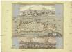
Insula Candia olim Creta
Kréta (Řecko) Weiland, Karl Ferdinand Visscher, Nicolaus N. Visscher
Candia, olim Creta. [Karte], in: Le théâtre du monde, ou, Nouvel atlas contenant les chartes et descriptions de tous les païs de la terre, Bd. 3, S. 309.
1 Karte aus Atlas Blaeu, Willem Janszoon und Blaeu, Joan Blaeu, Willem Janszoon
Ile de Crete
1 : 400000 Kréta (Řecko : ostrov) Service géographique de l'armée
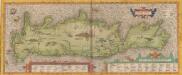
Candia cum Insulis aliquot circa Graeciam[:] [Zypern] [Karte], in: Gerardi Mercatoris Atlas, sive, Cosmographicae meditationes de fabrica mundi et fabricati figura, S. 493.
1 Karte aus Atlas Mercator, Gerhard Montanus, Petrus
Creta Iovis magni, medio iacet insula ponto. [Karte], in: Theatrum orbis terrarum, S. 416.
1 Karte aus Atlas Ortelius, Abraham
INSULA | CANDIA | olim | CRETA.
N. Visscher exc.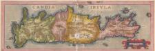
Candia Insula. [Karte], in: Theatrum orbis terrarum, S. 246.
1 Karte aus Atlas Ortelius, Abraham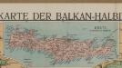
[Kreta]
Griechenland Kreta Osmanisches Reich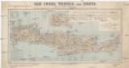
Die Insel Candia oder Creta
1 : 500000 Kréta (Řecko : ostrov) Dietrich Reimer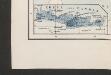
[Nebenkarte Kreta] Ethnographische Karte der europäischen Türkei und ihrer Dependenzen zu Anfang des Jahres 1877
Griechenland Kreta Ethnische Gruppe Sax, Carl
Insvla di Candia del mare Mediteranea
Kréta (Řecko) Peeters, Jacob Lauwers, Conrad Ioannes Peeters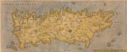
[Candia, Olim Creta.] [Karte], in: Theatrum orbis terrarum, S. 93.
1 Karte aus Atlas Ortelius, Abraham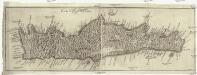
Carta del regno di Candia
Kréta (Řecko) Bouttats, Gaspar
Carta del regno di Candia
Kréta (Řecko) Bouttats, Gaspar
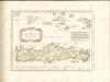
Creta insula hodie Ca[n]dia in medio ponto sita est
Kréta (Řecko) Duchet, Claude Claudij Ducheti
Candia cum insulis aliquot circa Græciam
1 Karte : Kupferdruck ; 22 x 46 cm, Bildgrösse 34 x 48 cm Mercator; Hondius Henricus Hondius