Maps of Marne

Catalauni
1 Karte : Kupferdruck ; 41 x 51 cm Sanson; Robert de Vaugondy chés le S. Robert geog. du roy quai de l'Horloge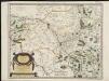
Catalauni : evesché de Chalons sur Marne, et en Champagne
1 : 211000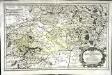
Rhemi
1 Karte : Kupferdruck ; 34 x 54 cm Sanson; Robert de Vaugondy chés le S. Robert geog. ord. du roy quai de l'Horloge du Palais
Département de la Marne
1 Karte : Kupferdruck ; 49 x 48 cm Houdan au bureau de l'atlas national de France rue Serpente no. 15 et au cabinet bibliographique rue de la vieille Monnoye no. 12
Chalons - sur - Marne 124, uit: Special-Karte von Mittel-Europa / nach amtlichen Quellen bearbeitet von W. Liebenow
1 : 300000 titelvariant: W. Liebenow's Mittel-Europa; Annotatie: Titel boven de bladen: W. Liebenow's Mittel-Europa Johannes Wilhelm Liebenow 1822-1897 Frankfurt a. M. : Ludwig Ravenstein
Chalons - sur Marne 124, uit: [W. Liebenow's Special-Karte von Mittel-Europa]
1 : 300000 titelvariant: W. Liebenow's Mittel-Europa; Annotatie: Titel boven de bladen: W. Liebenow's Mittel-Europa Johannes Wilhelm Liebenow 1822-1897 Hannover : Hermann Oppermann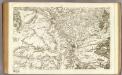
80 Chalons-en-Champagne.
1 : 86400 Cassini family; Cassini, Cesar-Francois, 1714-1784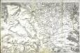
[Châlons-sur-Marne]
1 Blatt : 60 x 91 cm s.n.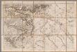
Chalons / réd. et gravée au Dépôt général de la Guerre sous la dir. de Pelet
1 : 80000 Jean Jacques Germain Pelet 1777-1858; Dépôt de la Guerre [Paris : Dépôt de la Guerre]
Plan‘‘sraženija pri Fer’’-Šampenuazě, 13 marta 1814 g.
Frankreich Fère-Champenoise Befreiungskriege <1813-1815>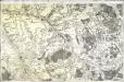
[Troyes]
1 Blatt : 60 x 90 cm s.n.
[Bar-le-Duc et environs]
1 : 20000 Annotatie: Herdruk van originele koperplaat; Oorspr. uitg.: ca. 1850 [Paris : I.G.N.]
Sheet 5, uit: Stanford's large scale map of the seat of war / Stanford's Geographical Estab[lishmen]t
1 : 300000 Stanford's Geographical Establishment, Londen London : Stanford
Generalkarte von Zentraleuropa
Champagne
1 Karte : Kupferdruck ; 17 x 24 cm Mercator Cloppenburgh
Champagne
1 : 505000 Champagne-oblast (Francie) apud Ioanem Ianßonium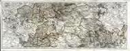
Carte du gouvernement de Champagne, 2
2 Blätter : 38 x 95 cm Bourgoin
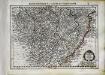
Département de la Marne
1 Karte : Kupferdruck ; 41 x 36 cm Capitaine s.n.
Département de la Marne
1 : 260000 Marne (Francie : departement) Houdan, d' P. G. Chanlaire et Dumez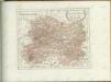

Tableau géographique et statistique du département de la Marne
1 : 620000 gravé par Le Gagneur Paris : Baudouin
SENONOIS, | & | LA PARTIE MERIDIONALE | DE LA CHAMPAGNE
[Amsterdam : Joan Blaeu]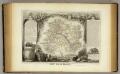
Dept. De La Marne.
1 : 561000 Levasseur, Victor.

DIOECESE | de | RHEIMS, | et le païs de | RETHEL, | Par Iean Iubrien | Chalonnois.
Amsterdami, Apud Guilj. et Ioan. Blaeuw

Le Theatre de Bellone :
Mollova mapová sbírka Schenk, Pieter Braakman, Adriaan
Tricasses
1 Karte : Kupferdruck ; 42 x 53 cm Sanson; Robert de Vaugondy ches le Sr. Robert geogr. ordin.re du roy quai de l'Horloge
La generalité de Paris, 2
1 Blatt : 67 x 52 cm chez l'auteur


