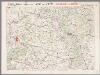
Maps of Marne

Sheet 5, uit: Stanford's large scale map of the seat of war / Stanford's Geographical Estab[lishmen]t
1 : 300000 Stanford's Geographical Establishment, Londen London : Stanford
Generalkarte von Zentraleuropa
Champagne
1 Karte : Kupferdruck ; 17 x 24 cm Mercator Cloppenburgh
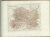
Département de la Marne
1 : 260000 Marne (Francie : departement) Houdan, d' P. G. Chanlaire et Dumez
Champagne
1 : 505000 Champagne-oblast (Francie) apud Ioanem Ianßonium
Département de la Marne
1 Karte : Kupferdruck ; 41 x 36 cm Capitaine s.n.
Le Theatre de Bellone :
Mollova mapová sbírka Schenk, Pieter Braakman, Adriaan
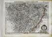
Tableau géographique et statistique du département de la Marne
1 : 620000 gravé par Le Gagneur Paris : Baudouin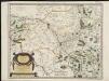
Catalauni : evesché de Chalons sur Marne, et en Champagne
1 : 211000
Catalauni
1 Karte : Kupferdruck ; 41 x 51 cm Sanson; Robert de Vaugondy chés le S. Robert geog. du roy quai de l'Horloge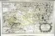
Rhemi
1 Karte : Kupferdruck ; 34 x 54 cm Sanson; Robert de Vaugondy chés le S. Robert geog. ord. du roy quai de l'Horloge du Palais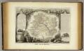
Dept. De La Marne.
1 : 561000 Levasseur, Victor.
Département de la Marne
1 Karte : Kupferdruck ; 49 x 48 cm Houdan au bureau de l'atlas national de France rue Serpente no. 15 et au cabinet bibliographique rue de la vieille Monnoye no. 12

Raspoloženie vojujuščich armij pri otkrytii Napoleonom pochoda
Frankreich Befreiungskriege <1813-1815>
Tricasses
1 Karte : Kupferdruck ; 42 x 53 cm Sanson; Robert de Vaugondy ches le Sr. Robert geogr. ordin.re du roy quai de l'Horloge
Carte du pays et diocese de Reims
1 : 171000 Remeš (Francie) Chalonnois, Jean Jubrien
Chalons - sur - Marne 124, uit: Special-Karte von Mittel-Europa / nach amtlichen Quellen bearbeitet von W. Liebenow
1 : 300000 titelvariant: W. Liebenow's Mittel-Europa; Annotatie: Titel boven de bladen: W. Liebenow's Mittel-Europa Johannes Wilhelm Liebenow 1822-1897 Frankfurt a. M. : Ludwig Ravenstein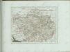

Chalons - sur Marne 124, uit: [W. Liebenow's Special-Karte von Mittel-Europa]
1 : 300000 titelvariant: W. Liebenow's Mittel-Europa; Annotatie: Titel boven de bladen: W. Liebenow's Mittel-Europa Johannes Wilhelm Liebenow 1822-1897 Hannover : Hermann Oppermann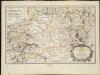
Rhemi : Partie meridionale du dioecese, et archevesché de Rheims en Champagne
1 : 211000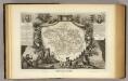
Dept. De L'Aube.
1 : 597000 Levasseur, Victor.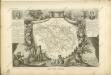
L'Aisne et la Meuse, uit: Le conflict mondial : front occidental
1 : 170000 Annotatie: Ontbreekt: no. 1 en 5-8 Gand : Th. de Graeve
Département de l'Aube
1 Karte : Kupferdruck ; 49 x 48 cm Houdan au bureau de l'atlas national de France rue Serpente no. 15 et au cabinet bibliographique rue de la vieille Monnoie no. 12
Département de l'Aube
1 Karte : Kupferdruck ; 33 x 41 cm Capitaine s.n.
Département de l'Aube
1 : 260000 Aube (Francie) P. G. Chanlaire et Dumez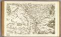
80 Chalons-en-Champagne.
1 : 86400 Cassini family; Cassini, Cesar-Francois, 1714-1784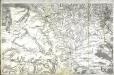
![Sheet 5, uit: Stanford's large scale map of the seat of war / Stanford's Geographical Estab[lishmen]t](https://images-2.georeferencer.com/images/iiif/037959615351/full/,300/0/native.jpg)

