Maps of Épernay

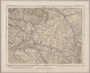
Chalons - sur - Marne 124, uit: Special-Karte von Mittel-Europa / nach amtlichen Quellen bearbeitet von W. Liebenow
1 : 300000 titelvariant: W. Liebenow's Mittel-Europa; Annotatie: Titel boven de bladen: W. Liebenow's Mittel-Europa Johannes Wilhelm Liebenow 1822-1897 Frankfurt a. M. : Ludwig Ravenstein
Chalons - sur Marne 124, uit: [W. Liebenow's Special-Karte von Mittel-Europa]
1 : 300000 titelvariant: W. Liebenow's Mittel-Europa; Annotatie: Titel boven de bladen: W. Liebenow's Mittel-Europa Johannes Wilhelm Liebenow 1822-1897 Hannover : Hermann Oppermann
Tricasses
1 Karte : Kupferdruck ; 42 x 53 cm Sanson; Robert de Vaugondy ches le Sr. Robert geogr. ordin.re du roy quai de l'Horloge
Catalauni
1 Karte : Kupferdruck ; 41 x 51 cm Sanson; Robert de Vaugondy chés le S. Robert geog. du roy quai de l'Horloge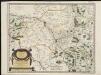
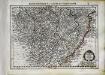
Catalauni : evesché de Chalons sur Marne, et en Champagne
1 : 211000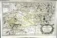
Rhemi
1 Karte : Kupferdruck ; 34 x 54 cm Sanson; Robert de Vaugondy chés le S. Robert geog. ord. du roy quai de l'Horloge du Palais
[Châlons-sur-Marne]
1 Blatt : 60 x 91 cm s.n.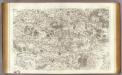
45 Meaux.
1 : 86400 Cassini family; Cassini, Cesar-Francois, 1714-1784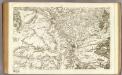
80 Chalons-en-Champagne.
1 : 86400 Cassini family; Cassini, Cesar-Francois, 1714-1784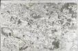
[Meaux]
1 Blatt : 60 x 91 cm s.n.
Plan‘‘sraženija pri Fer’’-Šampenuazě, 13 marta 1814 g.
Frankreich Fère-Champenoise Befreiungskriege <1813-1815>
Chalons / réd. et gravée au Dépôt général de la Guerre sous la dir. de Pelet
1 : 80000 Jean Jacques Germain Pelet 1777-1858; Dépôt de la Guerre [Paris : Dépôt de la Guerre]
Karta dlja ob‘‘jasnenija sraženiji pri Šampoberě, Monmiralě i Vošaně s‘‘ 29. Janv. Po 3 fevr. 1814 g.
Frankreich Champaubert Montmirail (Marne) Befreiungskriege <1813-1815> Champaubert / Schlacht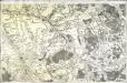
[Troyes]
1 Blatt : 60 x 90 cm s.n.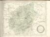

Plan de la ville, favxbovrgs et dependances de Troyes capitale de Champagne
1 : 9100 Troyes (Francie) Desbois, Maria
Generalkarte von Zentraleuropa
Champagne
1 Karte : Kupferdruck ; 17 x 24 cm Mercator Cloppenburgh
Champagne
1 : 505000 Champagne-oblast (Francie) apud Ioanem Ianßonium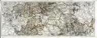
Carte du gouvernement de Champagne, 2
2 Blätter : 38 x 95 cm Bourgoin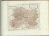

Campagne de 1814
1 : 464000 Champagne-oblast (Francie) Tardieu, Pierre
La generalité de Paris, 2
1 Blatt : 67 x 52 cm chez l'auteur
SENONOIS, | & | LA PARTIE MERIDIONALE | DE LA CHAMPAGNE
[Amsterdam : Joan Blaeu]
Département de la Marne
1 Karte : Kupferdruck ; 41 x 36 cm Capitaine s.n.
Carte des dérivations d'eaux de sources
1 : 320000 [s.n.]
Carte du gouvernement général de l'Isle de France, 2
1 Blatt : 79 x 55 cm Esnauts et Rapilly
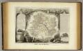
Dept. De La Marne.
1 : 561000 Levasseur, Victor.