Maps of Aisne

La generalité de Paris, 2
1 Blatt : 67 x 52 cm chez l'auteur
Carte du gouvernement général de l'Isle de France, 2
1 Blatt : 79 x 55 cm Esnauts et Rapilly
Campagne de 1814
1 : 464000 Champagne-oblast (Francie) Tardieu, Pierre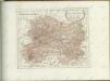

DIOECESE | de | RHEIMS, | et le païs de | RETHEL, | Par Iean Iubrien | Chalonnois.
Amsterdami, Apud Guilj. et Ioan. Blaeuw
Generalkarte von Zentraleuropa

Département de la Marne
1 Karte : Kupferdruck ; 41 x 36 cm Capitaine s.n.
Partie septentrionale du gouvernem. general de Champagne
1 Karte : Kupferdruck ; 47 x 58 cm Robert de Vaugondy; Haussard s.n.
Chalons - sur - Marne 124, uit: Special-Karte von Mittel-Europa / nach amtlichen Quellen bearbeitet von W. Liebenow
1 : 300000 titelvariant: W. Liebenow's Mittel-Europa; Annotatie: Titel boven de bladen: W. Liebenow's Mittel-Europa Johannes Wilhelm Liebenow 1822-1897 Frankfurt a. M. : Ludwig Ravenstein

Reims 110, uit: [W. Liebenow's Special-Karte von Mittel-Europa]
1 : 300000 titelvariant: W. Liebenow's Mittel-Europa; Annotatie: Titel boven de bladen: W. Liebenow's Mittel-Europa Johannes Wilhelm Liebenow 1822-1897 Hannover : Hermann Oppermann
Reims 110, uit: Special-Karte von Mittel-Europa / nach amtlichen Quellen bearbeitet von W. Liebenow
1 : 300000 titelvariant: W. Liebenow's Mittel-Europa; Annotatie: Titel boven de bladen: W. Liebenow's Mittel-Europa Johannes Wilhelm Liebenow 1822-1897 Frankfurt a. M. : Ludwig Ravenstein
Chalons - sur Marne 124, uit: [W. Liebenow's Special-Karte von Mittel-Europa]
1 : 300000 titelvariant: W. Liebenow's Mittel-Europa; Annotatie: Titel boven de bladen: W. Liebenow's Mittel-Europa Johannes Wilhelm Liebenow 1822-1897 Hannover : Hermann Oppermann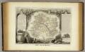
Dept. De La Marne.
1 : 561000 Levasseur, Victor.
Département de l'Aisne
1 Karte : Kupferdruck ; 55 x 40 cm Houdan au bureau de l'atlas national rue de la Harpe no. 26 et au dépôt de cet atlas placé au cabinet bibliographique rue de la Monnoye no. 5
Tricasses
1 Karte : Kupferdruck ; 42 x 53 cm Sanson; Robert de Vaugondy ches le Sr. Robert geogr. ordin.re du roy quai de l'Horloge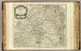
Champagne partie septentrionale.
1 : 315000 Robert de Vaugondy, Gilles, 1688-1766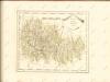

Suessones populi belgicæ secundæ
1 Karte : Kupferdruck ; 40 x 47 cm Sanson; Robert de Vaugondy chés le Sr. Robert geographe ord. du roi quai de l'Horloge du Palais
Département de l'Aisne
1 Karte : Kupferdruck ; 42 x 35 cm Capitaine s.n.
Département de la Marne
1 Karte : Kupferdruck ; 49 x 48 cm Houdan au bureau de l'atlas national de France rue Serpente no. 15 et au cabinet bibliographique rue de la vieille Monnoye no. 12
Sheet 5, uit: Stanford's large scale map of the seat of war / Stanford's Geographical Estab[lishmen]t
1 : 300000 Stanford's Geographical Establishment, Londen London : Stanford
Carte géologique du département de l'Aisne
1 : 160000 Alsasko (Francie) Archiac, d' d'Archiac
Tableau géographique et statistique du département de la Marne
1 : 620000 gravé par Le Gagneur Paris : Baudouin
Dept. De L'Aisne.
1 : 512000 Levasseur, Victor.
Carte du pays et diocese de Reims
1 : 171000 Remeš (Francie) Chalonnois, Jean Jubrien
Département de l'Aisne
1 Karte : Kupferdruck ; 55 x 40 cm Houdan au bureau de l'atlas national rue de la Harpe no. 26 et au dépôt de cet atlas placé au cabinet bibliographique rue de la Monnoye no. 5
Département de la Marne
1 : 260000 Marne (Francie : departement) Houdan, d' P. G. Chanlaire et Dumez
Stoel des Oorlogs in Champagnes Noorder Deel Teatre de la Guerre en Champagne Septentrione
1 : 250000 Mollova mapová sbírka Allard, Abraham Allart, Abraham


