Maps of Greenland

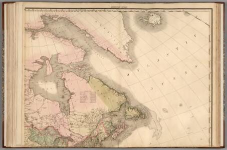
North America...N.E. Sheet.
1 : 7500000 Tanner, Henry S.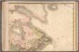
North America...N.E. Sheet.
1 : 7500000 Tanner, Henry S.
Canada - East. Pergamon World Atlas.
1 : 10000000 Polish Army Topography Service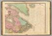
North America, N.E.. Sheet.
1 : 7600000 Tanner, Henry S.
Amerique Septentrionale 2.
1 : 7500000 Brue, Adrien Hubert, 1786-1832
Puissance du Canada.
1 : 10000000 Vivien St Martin, L.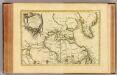
L'Amerique Septentrionale 1.
1 : 10050000 Bonne, Rigobert, 1727-1794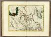
La Baja D'Hudson Terra di Labrador e Groenlandia.
1 : 9750000 Zatta, Antonio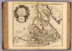
Canada, Nouvelle France.
1 : 9000000 L'Isle, Guillaume de, 1675-1726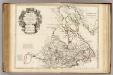
Canada, Nouvelle France.
1 : 9000000 L'Isle, Guillaume de, 1675-1726
Pas-caerte van Groenlandt, Yslandt, Straet Davids en Ian Mayen Eylant
1 Karte : Kupferdruck ; 43 x 52 cm Doncker bÿ Hendrick Doncker boekverkoper en graadbooghmaker inde Nieubrughsteegh
Greenland, Labrador.
1 : 15000000 Peterson, Augusts
Composite: L'Amerique Septentrionale.
1 : 10050000 Bonne, Rigobert, 1727-1794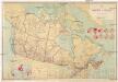
Map of the dominion of Canada
1 : 3600000 Kanada Robb, James, Alexander
Groenland und die angraenzenden Laender nach den Charten und Berichten von Cranz, Egede, Gieseke, Graah, Olavsen, Parry, Ross, Scoresby, Thorhallesen u.a.
1 : 5000000 entworfen und gezeichnet von Theodor Gliemann Weimar : Verlag des Geograph. Instituts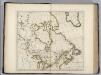
British Possessions in North America.
1 : 9100000 Carey, Mathew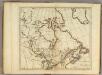
British Possessions in North America.
1 : 9000000 Carey, Mathew
British Possessions in North America.
1 : 6969600 Carey, Mathew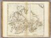
British Possessions in North America.
1 : 7603200 Carey, Mathew
British Possessions in North America.
1 : 7286400 Lewis, Samuel
British Possessions in North America.
1 : 7603200 Carey, Mathew
Map of part of the United States of North America : with the territory of the Illinois on the Ohio, particularly designed to illustrate Birkbeck's journey / Neele & Son, sc., 352 Strand.
from Parts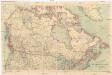
Stanford's general map of the Dominion of Canada and Newfoundland
1 : 5274720 Kanada Stanford, Edward Edward Stanford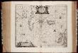
Typus Maritimus Groenlandiae, Islandiae, Freti Davidis, Insulae Iohannis Mayen, et Hitlandiae, Scotiae, et Hiberniae litora maritima Septentrionalia
1 : 7000000 Annotatie: Paskaart van de noordelijke Atlantische Oceaan met de kusten van met name het gebied tussen de Faeroër Eilanden, Groenland en Baffin Island; Origineel is Blad 149 in atlas factice; Kaart bevat diverse kompasrozen en is gedecoreerd met afbeeldingen van schepen en een walvis; Annotatie geografische gegevens: Met drie schaalstokken [Amstelodami] : [Apud Ioannem Ianßonium]
Partie orientale du Canada ou de la Nouvelle France : ou sont les provinces, ou pays de Sagvenay, Canada, Acadie etc., les peuples, ou nations des Etechemins, Iroquois, Attiquameches etc., auec la Nouvelle Angleterre, la Nouvelle Ecosse, la Nouvelle Yorc
from Charts and maps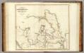
Arctic Regions.
1 : 19000000 Thomson, John
Gletscherkarte
Atlas der Geologie Zittel, K.v. ; Berghaus, Hermann Justus Perthes
The north west part of America / by Robt. Morden.; Geography rectified, or, A description of the world: in all its kingdoms, provinces, countries, islands, cities, towns, seas, rivers, bayes, capes, ports: their antient and present names, inhabitants, situations, histories, customs, governments, &c.: as also their commodities, coins, weights, and measures, compared with those at London: illustrated with above sixty new maps: the whole work performed according to the more accurate discoveries of modern authors / by Robert Morden.
from Geography rectified, or, A description of the world : in all its kingdoms, provinces, countries, islands, cities, towns, seas, rivers, bayes, capes, ports : their antient and present names, inhabitants, situations, histories, customs, governments, &c. : as also their commodities, coins, weights, and measures, compared with those at London : illustrated with above sixty new maps : the whole work performed according to the more accurate discoveries of modern authors / by Robert Morden. Morden, Robert; Cockerill, Thomas,
Carte marine, de la B. de Baffin, et une partie d'Hudson, d'Island et Groenland
1 Karte : Kupferdruck ; 42 x 48 cm Königliche Akademie der Wissenschaften