Maps of Dumfries and Galloway

England and Wales. England No. 2.
1 : 700000 Society for the Diffusion of Useful Knowledge (Great Britain)
Watershed map England, Wales 1.
1 : 760320 Letts, Son & Co.
England & Wales NW.
1 : 633600 Stanford, Edward
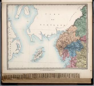
GALLOVIDIA | vernacule | GALLOWAY.
Auct. Timoth: Pont. [Amsterdam : Joan Blaeu]
Northumbria, Cumberlandia, Et Dunelmensis Episcopatus. [Karte], in: Atlas, sive, Cosmographicae meditationes de fabrica mundi et fabricati figura, S. 110.
1 Karte aus Atlas Mercator, Gerhard
Northumbria, Cumberlandia, Et Dunelmensis Episcopatus. [Karte], in: Gerardi Mercatoris Atlas, sive, Cosmographicae meditationes de fabrica mundi et fabricati figura, S. 112.
1 Karte aus Atlas Mercator, Gerhard Montanus, Petrus

Cumbria & Westmoria. Vulgo Cumberland & Westmorland. [Karte], in: Novus atlas absolutissimus, Bd. 8, S. 70.
1 Karte aus Atlas Janssonius Offizin
Cumbria; Vulgo Cumberland. [Karte], in: Theatrum orbis terrarum, sive, Atlas novus, Bd. 4, S. 490.
1 Karte aus Atlas Blaeu, Joan Blaeu, Willem Janszoon
Cumbria; Vulgo Cumberland. [Karte], in: Theatrum orbis terrarum, sive, Atlas novus, Bd. 4, S. 490.
1 Karte aus Atlas Blaeu, Joan Blaeu, Willem Janszoon
Cumbria; Vulgo Cumberland. [Karte], in: Le théâtre du monde, ou, Nouvel atlas contenant les chartes et descriptions de tous les païs de la terre, Bd. 4, S. 416.
1 Karte aus Atlas Blaeu, Willem Janszoon und Blaeu, Joan Blaeu, Willem Janszoon

Cumbria [et] Westmoria. vulgo Cumberland [and] Westmorland
1 Karte : Kupferdruck ; 41 x 52 cm Valck; Schenk apud G. Valk et P. Schenk
CVMBRIA; | Vulgo | CVMBERLAND.
[Amsterdam : Joan Blaeu]
Cumbria & Westmoria, vulgo Cumberland & Westmorland
1 : 330000 Amstelodami : apud Joannem Janssonium
Scotland / J. Ainslie, 8
1 Blatt : 68 x 57 cm Ainslie, Faden
WESTMORLANDIAE et Cumberlandiae Comit
This map of Westmorland and Cumbria is from the 1583 edition of the Saxton atlas of England and Wales.This atlas was first published as a whole in 1579. It consists of 35 coloured maps depicting the counties of England and Wales. The atlas is of great significance to British cartography as it set a standard of cartographic representation in Britain and the maps remained the basis for English county mapping, with few exceptions, until after 1750. During the reign of Elizabeth I map use became more common, with many government matters referring to increasingly accurate maps with consistent scales and symbols, made possible by advances in surveying techniques. Illustrating the increasing used of maps in government matters, Lord Burghley, Elizabeth I’s Secretary of State, who had been determined to have England and Wales mapped in detail from the 1550s, selected the cartographer Christopher Saxton to produce a detailed and consistent survey of the country. The financier of the project was Thomas Seckford Master of Requests at the Court of Elizabeth I, whose arms appear, along with the royal crest, on each map. Saxton, Christopher Ryther, Augustine
Sheet 2 England, North West, uit: Maps of England & Wales : scale 4 miles to 1 inch / Ordnance Survey
1 : 253440 titelvariant: Maps of England and Wales; Annotatie: Titel op cassette; Met bladoverzicht op de achterzijde van de cassette; Annotatie geografische gegevens: Hoogtelijneninterval 200 ft Ordnance Survey, United Kingdom Southampton : Ordnance Survey Office
delineation of the strata of England and Wales, with part of Scotland
1 : 320000 Blatt 3 Smith, William Cary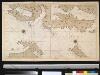
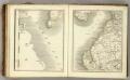
De Noord Oost kust van IJrlandt
Ireland Gerard van Keulen
Northumbria, Cumberlandia, et Dunelmensis Episcopatus
1 : 396000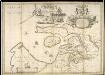
A new and exact map of the River Clyde done by the late Mr. John Adair / now publish'd for the good of the publick by Geo. Scott.
Adair, John, ca. 1650-1722
Scotland[Motoring Map of]
London : "Geographia
Scotland[Motoring Map of]
London : "Geographia
A new map of the counties of Cumberland and Westmoreland
1 Karte : Kupferdruck ; 66 x 50 cm Tinney; Bowles; Sayer; Bowles; Bowles printed for T. Bowles in St. Pauls Church Yard Rob.t Sayer and John Tinney in Fleet street and John Bowles and son in Cornhill
Cvmbria; vulgo Cvmberland
1 Karte : Kupferdruck ; 39 x 48 cm Blaeu Joan Blaeu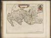
Gallovidia, vernacule Galloway / auct. Timoth. Pont.
Pont, Timothy, 1560?-1614? Blaeu, Joan, 1596-1673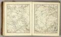
Sheets 66-67. (Cary's England, Wales, and Scotland).
1 : 360000 Cary, John, ca. 1754-1835
Gallovidia vernacule Galloway
1 Karte : Kupferdruck ; 40 x 51 cm Blaeu; Pont Joan Blaeu