Maps of Dumfries and Galloway
Gallovidia, vernacule Galloway / auct. Timoth. Pont.
Pont, Timothy, 1560?-1614? Blaeu, Joan, 1596-1673
Gallovidia vernacule Galloway
1 Karte : Kupferdruck ; 40 x 51 cm Blaeu; Pont Joan Blaeu
Galloway : Contains The Shires of Wigton and Kirkcudbright / Her. Moll.
Moll, Herman, d. 1732
Composite: Kirkcudbright-Shire.
1 : 114000 Thomson, John
Galloway, Sheet 1 - Bartholomew's "Half Inch to the Mile Maps" of Scotland
1 : 126720 Topographic maps John Bartholomew & Son, Ltd John Bartholomew & Son, Ltd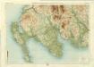
Wigtown, Sheet 1 - Bartholomew's "Half Inch to the Mile Maps" of Scotland
1 : 126720 Topographic maps Bartholomew, John George John Bartholomew & Co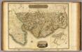
Kirkcudbright-Shire S.
1 : 114000 Thomson, John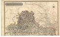
Kirkcudbright-Shire.
Thomson, John, 1777- ca. 1840 Johnson, William, fl. 1806-1840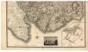
Kirkcudbright-Shire.
Thomson, John, 1777- ca. 1840 Johnson, William, fl. 1806-1840
The Stewartry of Kirkcudbright.
Ainslie, John, 1745-1828
The Stewartry of Kirkcudbright.
Ainslie, John, 1745-1828
The Stewartry of Kirkcudbright.
Ainslie, John, 1745-1828
The Stewartry of Kirkcudbright.
Ainslie, John, 1745-1828
Firth of Solway to Loch Ryan.
Great Britain. Hydrographic Office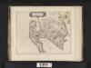
Gallovidiae, Pars Occidentalior, in qua Vicecomitatus Victoniensis cum Regalitate Glenucensi, [vulgo], The Sherifdome of Wigtoun wt the Regalitie of Glen-Luze, both in Galloway / auct. Timoth. Pont.
Pont, Timothy, 1560?-1614? Blaeu, Joan, 1596-1673
Gallovidiæ pars occidentalior, in qua vicecomitatvs Victoniensis cum regalitate Glenlucensi
1 Karte : Kupferdruck ; 40 x 51 cm Blaeu; Pont Joan Blaeu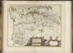
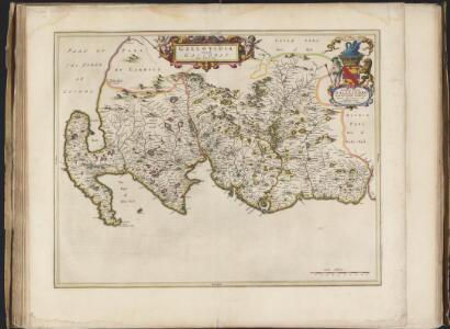
Praefectura Kircubriensis quae Gallovidiae maxime orientalis pars est. The Stuartrie of Kircubright, the most easterlie part of Galloway / auct. Tim. Pont.
Pont, Timothy, 1560?-1614? Blaeu, Joan, 1596-1673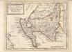
The West Part of Galloway : Contains The Shire of Wigton [i.e. Wigtown] / by H. Moll.
Moll, Herman, d. 1732
County of Wigton.
1 : 95000 Johnson, William, fl. 1806-1840
PRÆFECTVRA | KIRCVBRIENSIS, | quæ Gallovidiæ maxime orientalis pars est. | The Steuartrie of Kircubright, | The most easterlie part of Galloway.
Auct. Tim. Pont. [Amsterdam : Joan Blaeu]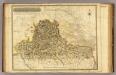
Kirkcudbright-Shire N.
1 : 114000 Thomson, John
Gallovidiæ pars media, quæ Deam et Cream fluvios interjacet
1 Karte : Kupferdruck ; 41 x 53 cm Blaeu; Pont Joan Blaeu
Wigtown - Bartholomew's 'Survey Atlas of Scotland'
1 : 126720 Topographic maps John Bartholomew & Son, Ltd John Bartholomew & Son, Ltd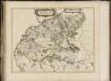
Gallovidiae pars media quae Deam et Cream fluvios interjacet, [vulgo], The Middle part of Galloway, which lyeth betweene the rivers Dee and Cree / auct. Timoth. Pont.
Pont, Timothy, 1560?-1614? Blaeu, Joan, 1596-1673
GALLOVIDIÆ | Pars Occidentalior, | in qua | VICECOMITATVS VICTONIENSIS | cum Regalitate Glenlucensi. [=] The Sherifdome of Wigtoun | wt the Regalitie of Glen-Luze | both in Galloway.
Auct. Timoth. Pont. [Amsterdam : Joan Blaeu]
GALLOVIDIÆ PARS MEDIA, | quæ Deam et Cream fluvios interjacet. | The Middle-part of Galloway, | whiche lyeth betweene the rivers Dee and Cree.
Auct. Tim. Pont. [Amsterdam : Joan Blaeu]
New Galloway - OS One-Inch Map
1 : 63360 Topographic maps Ordnance Survey Ordnance Survey
Kirkcudbright - OS One-Inch Map
1 : 63360 Topographic maps Ordnance Survey Ordnance Survey
Præfectvra Kircvbriensis, quæ Gallovidiæ maxime orientalis pars est
1 Karte : Kupferdruck ; 41 x 53 cm Blaeu; Pont Joan Blaeu