Maps of South Ayrshire
Sheets 64-65. (Cary's England, Wales, and Scotland).
1 : 360000 Cary, John, ca. 1754-1835
Campbeltown - Bartholomew's 'Survey Atlas of Scotland'
1 : 126720 Topographic maps John Bartholomew & Son, Ltd John Bartholomew & Son, Ltd
Girvan - OS One-Inch Map
1 : 63360 Topographic maps Ordnance Survey Ordnance Survey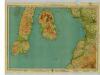
Arran & Lower Clyde, Sheet 3 - Bartholomew's "Half Inch to the Mile Maps" of Scotland
1 : 126720 Topographic maps John Bartholomew & Son, Ltd John Bartholomew & Son, Ltd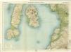
Arran & Lower Clyde, Sheet 3 - Bartholomew's "Half Inch to the Mile Maps" of Scotland
1 : 126720 Topographic maps Bartholomew, John George John Bartholomew & Co
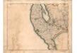
GALLOVIDIÆ | Pars Occidentalior, | in qua | VICECOMITATVS VICTONIENSIS | cum Regalitate Glenlucensi. [=] The Sherifdome of Wigtoun | wt the Regalitie of Glen-Luze | both in Galloway.
Auct. Timoth. Pont. [Amsterdam : Joan Blaeu]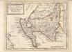
The West Part of Galloway : Contains The Shire of Wigton [i.e. Wigtown] / by H. Moll.
Moll, Herman, d. 1732
The South Part of the Shire of Air [i.e. Ayr], containing Kyle and Carrick / by H. Moll.
Moll, Herman, d. 1732
Ayrshire 3 S.
1 : 78000 Thomson, John
Caricta borealis vulgo the northpart of Carrick
1 Karte : Kupferdruck ; 41 x 51 cm Blaeu; Pont Joan Blaeu
Carricta meridionalis
1 Karte : Kupferdruck ; 37 x 51 cm Blaeu; Pont Joan Blaeu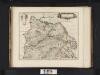
Caricta Borealis, vulgo, The northpart of Carrick / Opus Timothei Pont.
Pont, Timothy, 1560?-1614? Blaeu, Joan, 1596-1673
Ailsa Craig & Girvan (82) - OS One-Inch map
1 : 63360 Topographic maps Ordnance Survey Ordnance Survey
Ailsa Craig & Girvan (82) - OS One-Inch map
1 : 63360 Topographic maps Ordnance Survey Ordnance Survey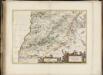
Carricta meridionalis, [vulgo], The South part of Carrick / auct. Timoth. Pont.
Pont, Timothy, 1560?-1614? Blaeu, Joan, 1596-1673
CARRICTA | MERIDIONALIS. | The South part of | CARRICK.
Auct. Tim. Pont. [Amsterdam : Joan Blaeu]
Campbelton - OS One-Inch map
1 : 63360 Topographic maps Ordnance Survey Ordnance Survey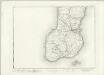
Campbelton - OS One-Inch map
1 : 63360 Topographic maps Ordnance Survey Ordnance Survey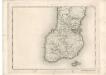
Campbelton - OS One-Inch map
1 : 63360 Topographic maps Ordnance Survey Ordnance Survey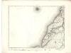
Girvan - OS One-Inch map
1 : 63360 Topographic maps Ordnance Survey Ordnance Survey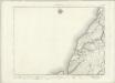
Girvan - OS One-Inch map
1 : 63360 Topographic maps Ordnance Survey Ordnance Survey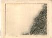
[Girvan] - OS One-Inch map
1 : 63360 Topographic maps Ordnance Survey Ordnance Survey
Arran - OS One-Inch map
1 : 63360 Topographic maps Ordnance Survey Ordnance Survey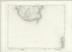
Arran - OS One-Inch map
1 : 63360 Topographic maps Ordnance Survey Ordnance Survey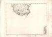
Arran - OS One-Inch map
1 : 63360 Topographic maps Ordnance Survey Ordnance Survey
Kintyre - OS One-Inch Map
1 : 63360 Topographic maps Ordnance Survey Ordnance Survey
CARICTA BOREALIS | Vulgo | The northpart of CARRICK.
Opus Timothei Pont. [Amsterdam : Joan Blaeu]
Gallovidiae, Pars Occidentalior, in qua Vicecomitatus Victoniensis cum Regalitate Glenucensi, [vulgo], The Sherifdome of Wigtoun wt the Regalitie of Glen-Luze, both in Galloway / auct. Timoth. Pont.
Pont, Timothy, 1560?-1614? Blaeu, Joan, 1596-1673
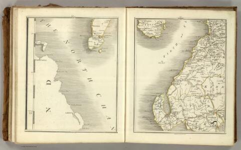
[Stranraer] - OS One-Inch map
1 : 63360 Topographic maps Ordnance Survey Ordnance Survey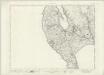
Stranraer - OS One-Inch map
1 : 63360 Topographic maps Ordnance Survey Ordnance Survey