Maps of Dumfries and Galloway

Scotland / J. Ainslie, 8
1 Blatt : 68 x 57 cm Ainslie, Faden
Scotland[Motoring Map of]
London : "Geographia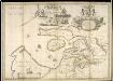
A new and exact map of the River Clyde done by the late Mr. John Adair / now publish'd for the good of the publick by Geo. Scott.
Adair, John, ca. 1650-1722
delineation of the strata of England and Wales, with part of Scotland
1 : 320000 Blatt 1 Smith, William Cary
A mape of the west of Scotland containing Clydsdail, Nithsdail, Ranfrew, Shyre of Ayre, & Galloway / authore Jo. Adair.
Adair, John, ca. 1650-1722
GALLOVIDIA | vernacule | GALLOWAY.
Auct. Timoth: Pont. [Amsterdam : Joan Blaeu]
Composite: Ayrshire
1 : 78000 Johnson, William, fl. 1806-1840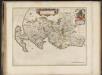
Gallovidia, vernacule Galloway / auct. Timoth. Pont.
Pont, Timothy, 1560?-1614? Blaeu, Joan, 1596-1673
Gallovidia vernacule Galloway
1 Karte : Kupferdruck ; 40 x 51 cm Blaeu; Pont Joan Blaeu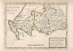
Galloway : Contains The Shires of Wigton and Kirkcudbright / Her. Moll.
Moll, Herman, d. 1732
Southern Part of Ayrshire.
Thomson, John, 1777- ca. 1840 Johnson, William, fl. 1806-1840
Northern Part of Ayrshire.
Thomson, John, 1777- ca. 1840 Johnson, William, fl. 1806-1840
Southern Part of Ayrshire.
Thomson, John, 1777- ca. 1840 Johnson, William, fl. 1806-1840
Northern Part of Ayrshire. Southern Part.
Thomson, John, 1777- ca. 1840 Johnson, William, fl. 1806-1840
A new map of Ayrshire...
Armstrong, Andrew, 1700-1794
A new map of Ayrshire...
Armstrong, Andrew, 1700-1794
A new map of Ayrshire...
Armstrong, Andrew, 1700-1794
A new map of Ayrshire...
Armstrong, Andrew, 1700-1794
A new map of Ayrshire...
Armstrong, Andrew, 1700-1794
A new map of Ayrshire...
Armstrong, Andrew, 1700-1794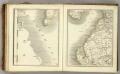
Sheets 64-65. (Cary's England, Wales, and Scotland).
1 : 360000 Cary, John, ca. 1754-1835
Firth of Solway to Loch Ryan.
Great Britain. Hydrographic Office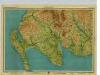
Galloway, Sheet 1 - Bartholomew's "Half Inch to the Mile Maps" of Scotland
1 : 126720 Topographic maps John Bartholomew & Son, Ltd John Bartholomew & Son, Ltd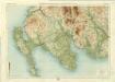
Wigtown, Sheet 1 - Bartholomew's "Half Inch to the Mile Maps" of Scotland
1 : 126720 Topographic maps Bartholomew, John George John Bartholomew & Co
GALLOVIDIÆ | Pars Occidentalior, | in qua | VICECOMITATVS VICTONIENSIS | cum Regalitate Glenlucensi. [=] The Sherifdome of Wigtoun | wt the Regalitie of Glen-Luze | both in Galloway.
Auct. Timoth. Pont. [Amsterdam : Joan Blaeu]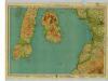
Arran & Lower Clyde, Sheet 3 - Bartholomew's "Half Inch to the Mile Maps" of Scotland
1 : 126720 Topographic maps John Bartholomew & Son, Ltd John Bartholomew & Son, Ltd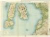
Arran & Lower Clyde, Sheet 3 - Bartholomew's "Half Inch to the Mile Maps" of Scotland
1 : 126720 Topographic maps Bartholomew, John George John Bartholomew & Co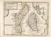
The Shire of Bute : contains Bute and Arran with Cantire [i.e. Kintyre] which is Part of Argyle Shire / by H. Moll.
Moll, Herman, d. 1732
Composite: Kirkcudbright-Shire.
1 : 114000 Thomson, John


