Maps of Scottish Borders

Scotland[Motoring Map of]
London : "Geographia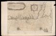
De Custen van Engelandt en Schotlandt tusschen Tinbij en Donde.
Blaeu, Willem Janszoon, 1571-1638
Carte des environs d'Edenburg
1 Karte : Kupferdruck ; 45 x 57 cm Robert de Vaugondy; Arrivet; Fortin; Dussy; Dorret chez le Sr. Fortin ing.r mécanicien du roy rue de la harpe près la rue du Foin
Scotland / J. Ainslie, 9
1 Blatt : 67 x 58 cm Ainslie, Faden
England and Wales 1:253,440
Ordnance Survey
Sheet 1 The Border, uit: Maps of England & Wales : scale 4 miles to 1 inch / Ordnance Survey
1 : 253440 titelvariant: Maps of England and Wales; Annotatie: Titel op cassette; Met bladoverzicht op de achterzijde van de cassette; Annotatie geografische gegevens: Hoogtelijneninterval 200 ft Ordnance Survey, United Kingdom Southampton : Ordnance Survey Office
Map of the Basin of the Forth.
Knox, James, fl. 1800-1856
Sheets 66-67. (Cary's England, Wales, and Scotland).
1 : 360000 Cary, John, ca. 1754-1835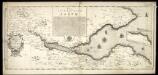
The River and Frith [sic] of Forth ... / Richard Cooper sculpt.
Adair, John, ca. 1650-1722 Cooper, Richard, 1705-1764
Sheets 75-76. (Cary's England, Wales, and Scotland).
1 : 360000 Cary, John, ca. 1754-1835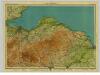
East Lothian, Sheet 9 - Bartholomew's "Half Inch to the Mile Maps" of Scotland
1 : 126720 Topographic maps John Bartholomew & Son, Ltd John Bartholomew & Son, Ltd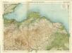
Berwick & Haddington, Sheet 9 - Bartholomew's "Half Inch to the Mile Maps" of Scotland
1 : 126720 Topographic maps Bartholomew, John George John Bartholomew & Co
Comitatus Northumbria vernacule Northumberland
1 : 300000 Amstelodami : apud Joannem Janssonium
Nieuwe en seer perfecte paskaart van Schotlandt ... van Berwyk tot Bokannais = A new and pertinent map of the eastern sea-coasts of Scotland ... from the cost of Berwik till Bokaness / by John Marr of
Marr, John, fl. 1660-1720
Comitatvs Northvmbria; vernacula Northvmberland
1 Karte : Kupferdruck ; 39 x 48 cm Blaeu Joan Blaeu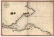
Survey of the Frith [sic] of Forth, by George Thomas... in 1815
Thomas, George, fl. 1809-1846 Great Britain. Hydrographic Office
A Platt of the opposete Borders of Scotland to ye west marches of England
This is a map of the opposite borders of Scotland and England. It is from an atlas that belonged to William Cecil Lord Burghley, Elizabeth I’s Secretary of State. Burghley used this atlas to illustrate domestic matters. This map is interesting because it shows the debatable lands, these were lands between the borders of Scotland and England, claimed by neither and subsequently a lawless no-man’s land. Lord Burghley has annotated the map, adding place names at points along the river which forms part of the border, and the river immediately to the right of this which lies on English soil. The title, "A Platt of the opposete Borders of Scotland to ye west marches of England" appears on the reverse with the date:"Dec. 1590". There is a description on the map itself which ends: "for those on the English coast they ar referred to the tract latly sent to your L. of the description of them in particular". A scale bar of 4" - 10 [miles] is included. William Cecil, Lord Burghley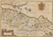
Provincae Lauden seu Lothien et Linlitouo [Karte], in: Novus atlas absolutissimus, Bd. 8, S. 129.
1 Karte aus Atlas Janssonius Offizin
LOTHIAN | and | LINLITQVO
Joh. et Cornelius Blaeu exc.
Border Country, Sheet 5 - Bartholomew's "Half Inch to the Mile Maps" of Scotland
1 : 126720 Topographic maps John Bartholomew & Son, Ltd John Bartholomew & Son, Ltd
Moffat, Hawick & Border, Sheet 5 - Bartholomew's "Half Inch to the Mile Maps" of Scotland
1 : 126720 Topographic maps Bartholomew, John George John Bartholomew & Co
TVEDIA | cum vicecomitatu Etterico Forestæ. | etiam Selkirke dictus | TWEE-DAIL | with the Sherifdome of Etterik-Forrest | called also Selkirk
Auct. Tomotheo Pont. [Amsterdam : Joan Blaeu]
TEVIOTIA | Vulgo | TIVEDAIL
[Amsterdam : Joan Blaeu]
A New Description of the Shyres Lothian und Linlitquo. [Karte], in: Gerardi Mercatoris et I. Hondii Newer Atlas, oder, Grosses Weltbuch, Bd. 1, S. 72.
1 Karte aus Atlas Mercator, Gerhard und Hondius, Jodocus Jansson, Jan
Anandale : is Part of Dumfreis Shire. Eusdale or Eskdale and Liddesdale is the South Part of Roxburgh Sh. / H. Moll.
Moll, Herman, d. 1732
Map of the three Lothians.
Armstrong, Andrew, 1700-1794 Armstrong, Mostyn, fl. 1769-1791
A New and Correct map of the Lothians from Mr. Adair's observations / by John Elphinstone ; Thos. Smith, Edin, sculpsit.
Elphinstone, John, 1706-1753 Smith, Thomas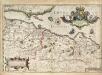
A new description of the shyres Lothian and Linlitquo / T. Pont ; Jodocus Hondius caelavit sumptibus Andrae Hart.
Pont, Timothy, 1560?-1614? Hondius, Hendrik, b. 1573
Map of the three Lothians.
Armstrong, Andrew, 1700-1794 Armstrong, Mostyn, fl. 1769-1791
Map of the three Lothians.
Armstrong, Andrew, 1700-1794 Armstrong, Mostyn, fl. 1769-1791
Map of the three Lothians.
Armstrong, Andrew, 1700-1794 Armstrong, Mostyn, fl. 1769-1791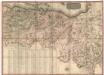
A map of the environs of Edinburgh.
Kirkwood, Robert, fl. 1806-1828
Map of the three Lothians.
Armstrong, Andrew, 1700-1794 Armstrong, Mostyn, fl. 1769-1791
Map of the three Lothians.
Armstrong, Andrew, 1700-1794 Armstrong, Mostyn, fl. 1769-1791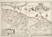
![Scotland[Motoring Map of]](https://images-2.georeferencer.com/images/iiif/783303541435/full/,300/0/native.jpg)

