Maps of Bridgetown

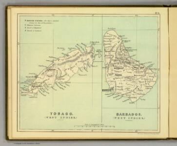
Tobago; Barbados.
1 : 338000 Peterson, Augusts
Novissima et Acuratissima Barbados. Descriptio per Johannem Ogiluium Cosmographum Regium
from America: being the latest, and most accurate description of the Nevv vvorld; containing the original of the inhabitants, and the remarkable voyages thither. The conquest of the vast empires of Mexico and Peru, and other large provinces and territories, with the several European plantations in those parts. Also their cities, fortresses, towns, temples, mountains, and rivers. Their habits, customs, manners, and religions. Their plants, beasts, birds, and serpents. With an appendix, containing, besides several other considerable additions, a brief survey of what hath been discover'd of the vnknown south-land and the Arctick region. Collected from most authentick authors, augmented with later observations, and adorn'd with maps and sculptures, by John Ogilby ...
Nieuwe land en zeekaart van het eyland Barbados geleegen in West India onder de Caribesse Eylande
1 : 47500
The island of Barbadoes, divided into its parishes, with the roads, paths, &c. according to an actual and accurate survey
1 : 85000
Tobago from actual surveys and observations.
1 : 63360 Ross, David
Barbadoes
1 : 65000
A Topographical Map of the Island of Barbados, based on a survey taken by W. Mayo, in 1721, corrected and improved to 1859 by A. Taylor
A Topographical Map of the Island of Barbados, based on a survey taken by W. Mayo, in 1721, corrected and improved to 1859 by A. Taylor. W. Mayo London : T. F. Cross
Carte de l'Isle de La Barbade, avec une description geographique de cette isle
1 : 85000
The island of Barbadoes : divided into its parishes, with the roads, paths, &c. according to an actual and accurate survey
1 : 85000 Moll, Herman, d. 1732 Printed and sold by Tho. Bowles, next ye Chapter House in St. Pauls Church yard & I. Bowles at the Black Horse in Cornhill
Island of Barbadoes
1 : 85000 Moll, Herman, d. 1732
Carte de L'Isle de La Barbade : avec une description geographique de cette isle
1 : 85000 Bellin, Jacques Nicolas, 1703-1772 [Didot]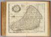
Barbadoes.
1 : 85000 Bowen, Emanuel
Map of Barbados
This is a map of the island of Barbados and is from the late 17th century. It shows the coast of the island in detail, harbours are marked with an anchor, and rocky areas are shown with a series of small crosses and a yellow line. The names of settlements are marked, and, in the centre of the map, a compass rose orientates the map to the North.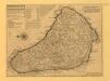
The Island of Barbados
The Island of Barbadoes, by H. Moll. H. Moll
A New and exact Map of the Island of Barbados
A New and exact Map of the Island of Barbadoes in America ... By William Mayo. (A Plan of BridgeTown. Scale ... 50 perches[ = 3 inches]). William Mayo
Insurance Plan of Bridgetown Barbados (Sheet 2)
Insurance Plan of Bridgetown Barbados ... [By] C.E. Goad ... Scale, 50 ft. = 1 inch Key-Plan, 504 ft. = 1 inch. London
Insurance Plan of Bridgetown Barbados (Sheet 4)
Insurance Plan of Bridgetown Barbados ... [By] C.E. Goad ... Scale, 50 ft. = 1 inch Key-Plan, 504 ft. = 1 inch. London
Insurance Plan of Bridgetown Barbados (Sheet 5)
Insurance Plan of Bridgetown Barbados ... [By] C.E. Goad ... Scale, 50 ft. = 1 inch Key-Plan, 504 ft. = 1 inch. London
Barbadoes.
1 : 142966 Lucas, Fielding Jr.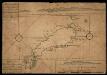
Map Of Tobago Showing Native Dwellings
Map of Tobago as it was in the year 1756. Rocks and other obstructions off the coast are marked with crosses and the depth of the water in the harbours is shown in fathoms. The names of the larger bays are given in both English and French. Along the upper edge of the map is a coastal view of the north east of the island and along the lower edge is the coast line of the south west. The map carries the annotations, ?On this Rock his Majesty's Ship Chesterfield Struck having XV Fathom the Cast Before. Anno 1749.? and ?The French Fort Burnt in 1749.?
Tobago.
1 : 164736 Lucas, Fielding Jr.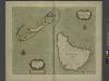
The Iland of BARBADOS
from The sea-atlas : containing an hydrographical description of most of the sea-coasts of the known parts of the world.
Map of the Windward Islands.
1 : 887040 Arrowsmith, John
Windward Islands.
1 : 887040 Stanford, Edward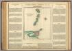
Windward Islands.
1 : 2100000 Lea, I.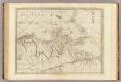
The coast of Caracas, Cumana, Parla and the mouths of Rio Orinoco.
1 : 1560000 Jefferys, Thomas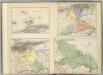
(Provincias de Margarita, Cumana, Barcelona, Guayana)
1 : 1300000 Codazzi, Agustin, 1793-1859
Carte des Antilles francoises et des isles voisines
1 : 870000
Tabula novissima atque accuratissima Caraibicarum insularum sive Cannibalum, quae etiam Antillae Gallicae dicuntur, item insulae Supraventum, et in Archipelago Mexicano sitae sunt, ac detectae a Christ. Columbo Ao. MCCCCLXXXXIII
1 : 960000
Antilles Francoises, isles voisines.
1 : 890000 L'Isle, Guillaume de, 1675-1726