Maps of Guadeloupe

Antilles Francoises, isles voisines.
1 : 890000 L'Isle, Guillaume de, 1675-1726
Antilles Francoises, isles voisines.
1 : 890000 L'Isle, Guillaume de, 1675-1726
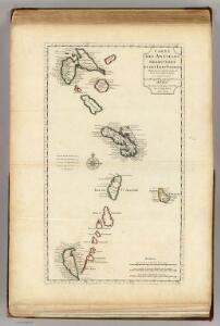
Carte des Antilles francoises et des isles voisines
1 : 870000
Tabula novissima atque accuratissima Caraibicarum insularum sive Cannibalum, quae etiam Antillae Gallicae dicuntur, item insulae Supraventum, et in Archipelago Mexicano sitae sunt, ac detectae a Christ. Columbo Ao. MCCCCLXXXXIII
1 : 960000
Tabula novissima atque accuratissima Caraibicarum insularum sive Cannibalum : quae etiam Antillae Gallicae dicuntur, item insulae Supraventum, et in Archipelago Mexicano sitae sunt, ac detectae a Christ. Columbo Ao. MCCCCLXXXXIII
1 : 960000 Ottens, R. (Reinier), 1698-1750 by de Wed. I. Ottens, op den Nieuwen Dyk in de Werelt Kaart
A map of the islands of St. Lucia and Martinique, with part of Dominica and St. Vincents, shewing the two passages between Martinique and St. Lucia, and Martinique and Dominica, to Fort Royal Bay and harbour, the station of the French fleets ...
1 : 1
Isle de la Martinique
1 : 7320000 Guadeloupe Bonne, Rigobert André
Guadaloupe.
1 : 300000 Jefferys, Thomas
Tobago; Barbados.
1 : 338000 Peterson, Augusts
Guadaloupe.
1 : 120000 Thomson, John
Guadaloupe & c.
1 : 283583 Lucas, Fielding Jr.
Guadaloupe, done from actual surveys and observations of the English, whilst the island was in their possession
1 : 300000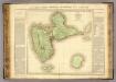
Guadeloupe.
1 : 65000 Boyer-Peyreleau, Eugene Edouard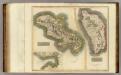
Martinico, Dominica.
1 : 200000 Thomson, John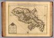
Martinique.
1 : 175000 L'Isle, Guillaume de, 1675-1726
Colonies Francaises (en Amerique).
1 : 476000 Levasseur, Victor.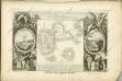
Isle de la Guadeloupe
1 : 367500
CHARTE von der Insel GUADELOUPE
1 : 500000 Guadeloupe Pluth, Fr.

Charte von der Insel Guadeloupe

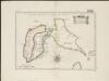
Carte de la Dominique prise par les françois le 7 septembre 1778, avec le Plan du débarquement, et de l'attague des forts et batteries par les troupes et les frégates de Sa Majesté
1 : 60000
Dominica from an actual survey compleated in the year 1773
1 : 85000
Guadaloupe, one of the Caribbee Islands subject to France in the West Indies
1 : 265000 Jefferys, Thomas, d. 1771 T. Jefferys at Charing Cross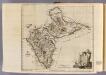
Guadaloupe.
1 : 265000 Jefferys, Thomas
Martinico.
1 : 167366 Lucas, Fielding Jr.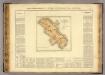
Martinique.
1 : 235000 Buchon, J. A. C.; Carey, H. C.; Lea, I.
Insula Matanino Vulgo Martanico [Karte], in: Novus atlas absolutissimus, Bd. 9, S. 71.
1 Karte aus Atlas Janssonius Offizin
INSULA MATANINO Vulgo MARTANICO
1 : 130000 Martinik Visscher, Nicolaus in lucem edita per Nicolaum Visscher