Maps of Suffolk County
Colton's New Map Of Long Island.
1 : 126720 Colton, G.W.
Map Of Long Island, New York.
1 : 125000 U.S. Geological Survey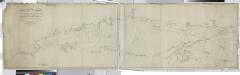
Long Island Sound from New York to Montock Point / surveyed in the years 1828, 29, & 30, by Edmund Blunt ; the writing by D.R. Harrison ; plan by W. Hooker ; W. Hooker, engraver & copper-plate printer, Franklin Hall, N.Y.
from Long Island
Map of the county of Suffolk / by David H. Burr ; engd. by Rawdon Clark & Co., Albany, & Rawdon, Wright & Co., N. York.
from An atlas of the state of New York : containing a map of the state and of the several counties / by David H. Burr.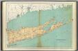
Suffolk County.
1 : 158400 Bien, Joseph Rudolf
Map of the county of Suffolk / by David H. Burr ; engd. by Rawdon Clark & Co., Albany, & Rawdon, Wright & Co., N. York.
from An atlas of the state of New York, designed for the use of engineers, containing a map of the state and of the several counties. / Projected and drawn ... under the superintendence and direction of Simeon de Witt.
Brooklyn land use policy
From The Borough
Map of the county of Suffolk / by David H. Burr ; engd. by Rawdon Clark & Co., Albany, & Rawdon, Wright & Co., N. York.
from An atlas of the state of New York : containing a map of the state and of the several counties. / Projected and drawn under the superintendence and direction of Simeon de Witt ... And also the physical geography of the State ...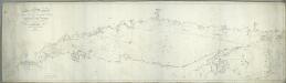
Long Island Sound from New York to Montock Point / surveyed in the years 1828, 29, & 30, by Edmund Blunt ; the writing by D.R. Harrison ; plan by W. Hooker ; W. Hooker, engraver & copper-plate printer, Franklin Hall, N.Y.
from Charts and maps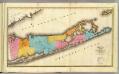
Suffolk County.
1 : 170000 Burr, David H., 1803-1875
New York, Queens, Kings, Richmond counties.
1 : 158400 Burr, David H., 1803-1875
Map of the county of Westchester / by David H. Burr; engd. by Rawdon, Clark & Co., Albany, & Rawdon, Wright & Co., New York.; An atlas of the state of New York: containing a map of the state and of the several counties / by David H. Burr.
from An atlas of the state of New York : containing a map of the state and of the several counties / by David H. Burr. Burr, David H.; Rawdon, Clark & Co.; Rawdon, Wright & Co.; Stone & Clark Republishers,
Map of the county of Westchester / by David H. Burr; engd. by Rawdon, Clark & Co., Albany, & Rawdon, Wright & Co., New York.; An atlas of the state of New York, designed for the use of engineers, containing a map of the state and of the several counties. / Projected and drawn ... under the superintendence and direction of Simeon de Witt.
from An atlas of the state of New York, designed for the use of engineers, containing a map of the state and of the several counties. / Projected and drawn ... under the superintendence and direction of Simeon de Witt. Burr, David H.; De Witt, Simeon; Rawdon, Clark & Co.; Rawdon, Wright & Co.; Stone & Clark Republishers,
Cortlandt Manor map : prepared expressly for this work / copied for Piere Van Cortlandt esqr., June 1774, by G. Baneker.
from Cities and towns, A-Z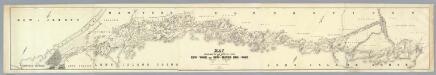
Map Exhibiting The ... Lines for the New-York and New-Haven Rail-Road.
1 : 40000 Anderson, P.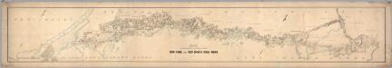
Map Exhibiting The ... Lines for the New-York and New-Haven Rail-Road.
1 : 20000 Anderson, P.
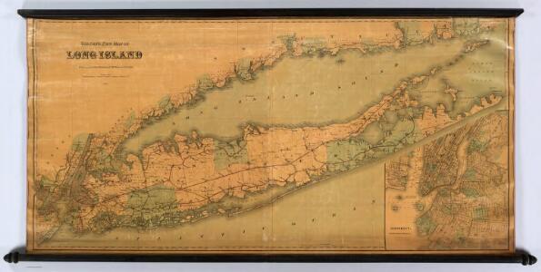
Map of Long Island with the environs of New-York and the southern part of Connecticut / compiled from various surveys & documents by J. Calvin Smith ; engraved & printed by S. Stiles & Co., N. York.
From Long Island
Map of enlarged city of Brooklyn, from official records and surveys.
From Brooklyn
Map of the county of Westchester / by David H. Burr ; engd. by Rawdon, Clark & Co., Albany, & Rawdon, Wright & Co., New York.
from An atlas of the state of New York : containing a map of the state and of the several counties. / Projected and drawn under the superintendence and direction of Simeon de Witt ... And also the physical geography of the State ...
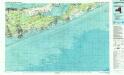
Shell Metropolitan New York and Long Island. Eastern Long Island.
1 : 126720 Shell Oil Company
Westchester Co. & surroundings.
1 : 253440 Bien, Joseph Rudolf
N.Y., Kings, Queens, Richmond, Rockland, Westchester, Putnam counties.
1 : 158400 Bien, Joseph Rudolf
196. New York, Washington D.C.. The World Atlas.
1 : 250000 USSR (Union of Soviet Socialist Republics).
Map of the City of Brooklyn as consolidated by an act of the Legislature of the Ste of New York . . . Constructed from the official maps of the Commissioners . . . Exhibiting the farm lines names of the original owners.
From Brooklyn
[A chart of New York Island & North River, East River, passage through Hell Gate, Flushing Bay, Hampstead Bay, Oyster Bay, Huntington Bay, Cow Harbour, East Chester Inlet, Rochelle, Rye, Patrick Islands, &c.]
from Charts and maps
Long Island West
1 : 100000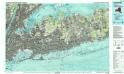
Long Island West
1 : 100000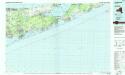
Long Island East
1 : 100000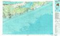
Long Island East
1 : 100000