Maps of Nassau County
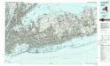
Long Island West
1 : 100000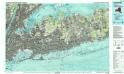
Long Island West
1 : 100000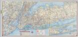
Shell Metropolitan New York and Long Island. Eastern Long Island.
1 : 126720 Shell Oil Company
Greater New York's census districts, 1920 : compiled from map prepared 1915-1918 for the 1920 census by the New York Federation of Churches.
From Manhattan
Map of enlarged city of Brooklyn, from official records and surveys.
From Brooklyn
[A chart of New York Island & North River, East River, passage through Hell Gate, Flushing Bay, Hampstead Bay, Oyster Bay, Huntington Bay, Cow Harbour, East Chester Inlet, Rochelle, Rye, Patrick Islands, &c.]
from Charts and maps
Islip
1 : 125000
Islip
1 : 125000
Islip
1 : 125000
Islip
1 : 125000
Islip
1 : 125000
Islip
1 : 125000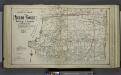
Lower section Index Map of Nassau County Long Island Published by E. Belcher Hype. 97 Liberty St. Brooklyn, 5 Beekman St. Manhattan. 1914.
from Atlas of Nassau County, Long Island, N.Y. Complete in one volume. Historical, statistical. Based upon maps on file at the county seat in Mineola and upon private plans and surveys furnished by surveyors and individual owners. Supplemented by careful measurements & field observations by our own corps of engineers.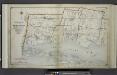
Index Map No.1 of a part of Suffolk County. South Side - Ocean Shore, Long Island. Townships of Babylon and Part of Islip Published by E. Belcher Hyde. 97 Liberty Street, Brooklyn. 5 Beekman Street, Manhattan. 1915. Volume One.
from Atlas of ... Suffolk County, Long Island, New York ... : based upon actual measurements by our own corps of engineers, maps on file at county offices, also maps from actual surveys furnished by individual owners / under the supervision of Merritt B. Hyde.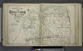
Upper section Index Map of Nassau County Long Island Published by E. Belcher Hype. 97 Liberty St. Brooklyn, 5 Beekman St. Manhattan. 1914.
from Atlas of Nassau County, Long Island, N.Y. Complete in one volume. Historical, statistical. Based upon maps on file at the county seat in Mineola and upon private plans and surveys furnished by surveyors and individual owners. Supplemented by careful measurements & field observations by our own corps of engineers.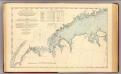
N.Y.-Norwalk Is.
1 : 80000 United States Coast Survey
Birds Eye View Map Of New York And Vicinity.
1 : 80033 Hammond, C.S.
Street Indexed map of the Borough of Queens, also showing the Congressional Districts.
From Queens
Outline and Index Map of the Borough of Queens, City of New York.
from Atlas of the city of New York, borough of Queens, Long Island City, Newtown, Flushing, Jamaica, Far Rockaway, from actual surveys and official plans / by George W. and Walter S. Bromley.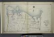
Index Map No. 1 of a part of Suffolk County. North Side - Sound Shore, Long Island. Huntington and Smith Town. Published by E. Belcher Hyde. 97 Liberty Street, Brooklyn. 5 Beekman Street, Manhattan. 1917. Volume One.
from Atlas of ... Suffolk County, Long Island, New York ... : based upon actual measurements by our own corps of engineers, maps on file at county offices, also maps from actual surveys furnished by individual owners / under the supervision of Merritt B. Hyde.
New map of Kings and Queens counties : from actual Surveys.
From Brooklyn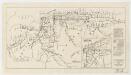
Map showing routes & stations on the dual system October, 1918
1 : 46000 New York (State). Public Service Commission State of New York Public Service Commission for the First District
New York Island, Part of Long Island .
1 : 100000 Marshall, John
New Guide Map of Manhattan and The Bronx.
From Manhattan
Map of the Borough of Manhattan and part of the Bronx showing location and extent of racial colonies.
From Manhattan
Map of Queens Borough, City of New York.
From Queens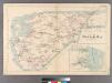
Plate 32: Town of Oyster Bay.
from Atlas of Queens Co., Long Island, New York / compiled from official records, private plans & actual surveys by and under the direction of Chester Wolverton.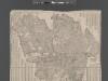
Street Indexed map of the Borough of Queens, also showing the Congressional Districts.
From Queens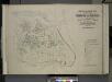
Index map to Vol. 3; Atlas of the Borough of Queens Third Ward city of New York. Published by E. Belcher Hyde; 97 Liberty St., Brooklyn Borough. 1904.
from Third ward: Flushing.

