Maps of Westchester County

Westchester Co. & surroundings.
1 : 253440 Bien, Joseph Rudolf
196. New York, Washington D.C.. The World Atlas.
1 : 250000 USSR (Union of Soviet Socialist Republics).
N.Y., Kings, Queens, Richmond, Rockland, Westchester, Putnam counties.
1 : 158400 Bien, Joseph Rudolf
Chief Engineer's Office. Board of Estimate and Apportionment. Index Map. Showing Location of the Sectional Plans of the City of New York.
from Height district map / City of New York, Board of Estimate and Apportionment.
Cortlandt Manor map : prepared expressly for this work / copied for Piere Van Cortlandt esqr., June 1774, by G. Baneker.
from Cities and towns, A-Z
Map of the Hudson ... from Tarrytown to Dunderbergh.
from Map of the Hudson between Sandy Hook & Sandy Hill : with the post road between New York and Albany / Bridges delt. ; Rollinson sct.
New York City Vicinity. Pergamon World Atlas.
1 : 250000 Polish Army Topography Service
[Rockland County].
from Atlas of New York.
Mass Transit program New York City
From The Borough
Map of New York City, (Greater New York).
From Manhattan
Index to Sectional aerial maps of the City of New York / [photographed and assembled under the direction of the chief engineer, July 1st, 1924].
from Sectional aerial maps of the City of New York / [photographed and assembled under the direction of the chief engineer, July 1st, 1924].
Map of the Country Twenty Five Miles Round The City Of New-York.
1 : 300000 Greenleaf, Jeremiah
Map of the Country Twenty Five Miles Round The City Of New-York.
1 : 316800 Greenleaf, Jeremiah
Map of enlarged city of Brooklyn, from official records and surveys.
From Brooklyn
Map of the Country Twenty Five Miles Round The City Of New-York.
1 : 211200 Burr, David H., 1803-1875
Linear development concept for Morrisania
From District 3
New York and vicinity [map]
1 : 24000 Geological Survey (U.S.) Geological Survey
Hammods Atlas of New York City and the metropolitan district

Map of the Borough of Brooklyn, N. Y., and vicinity showing the street railway system controlled by the Brooklyn rapid transit system.
From Brooklyn
Westchester County.
1 : 151000 Burr, David H., 1803-1875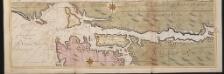
Nieuwe afteekeningh van de Noord Rivier met alle desselfs ancker plaetsen dieptens banken en klippen, geleegen in Nieuw Nederlandt [north part]
United States Gerard van Keulen
Panorama of the Borough of the Bronx issued by the Bronx Home News.
From Bronx
New York City Free Public Educational Institutions, 1911 ; prepared by the Dept. of Public Education, American Museum of Natural History.
From Manhattan
New York City and Environs.
1 : 30000 Walling, H. F.
New York City and vicinity / H.M. Wilson, geographer in charge ; triangulation by U.S. Coast and Geodetic Survey ; topography by S.H. Bodfish ... [et al.]
1 : 62500 Annotatie geografische gegevens: Opname: 1887-1889, 1897 Wilson, H. M.; Bodfish, S. H.; US Coast and Geodetic Survey [Washington, D.C. : U.S. Geological Survey]
The Hudson by daylight map, from New York Bay to the head of tide water : containing names of streams, islands, and heights of mountains according to the latest coast survey : also the names of prominent residences, historic land marks, the old reaches o
from Hudson River
Sanitation
From Environment
Educational Extension Work of the Ameriocan Museum of Natrural History. Public Schools supplied by the Museum with Nature Study Collections or Lectures in 1919.
From Manhattan
A plan of the operations of the King's army under the command of General Sr. William Howe, K.B. in New York and east New Jersey against the American forces commanded by General Washington from the 12th. of October, to the 28th. of November 1776 ...
1 : 88000 Sauthier, Claude Joseph Stedman, Charles


