Maps of New York

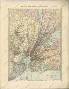
Hammods Atlas of New York City and the metropolitan district

New York City Vicinity. Pergamon World Atlas.
1 : 250000 Polish Army Topography Service
New York City and Environs.
1 : 30000 Walling, H. F.
Index to Sectional aerial maps of the City of New York / [photographed and assembled under the direction of the chief engineer, July 1st, 1924].
from Sectional aerial maps of the City of New York / [photographed and assembled under the direction of the chief engineer, July 1st, 1924].
Educational Extension Work of the Ameriocan Museum of Natrural History. Public Schools supplied by the Museum with Nature Study Collections or Lectures in 1919.
From Manhattan
Mass Transit program New York City
From The Borough
New York City Free Public Educational Institutions, 1911 ; prepared by the Dept. of Public Education, American Museum of Natural History.
From Manhattan
New York City and vicinity
1 : 62500 United States Geological Survey U.S. Geological Survey
Sanitation
From Environment
Map of the Borough of Brooklyn, N. Y., and vicinity showing the street railway system controlled by the Brooklyn rapid transit system.
From Brooklyn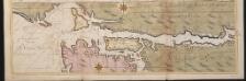
Nieuwe afteekeningh van de Noord Rivier met alle desselfs ancker plaetsen dieptens banken en klippen, geleegen in Nieuw Nederlandt [north part]
United States Gerard van Keulen
New York City and vicinity / H.M. Wilson, geographer in charge ; triangulation by U.S. Coast and Geodetic Survey ; topography by S.H. Bodfish ... [et al.]
1 : 62500 Annotatie geografische gegevens: Opname: 1887-1889, 1897 Wilson, H. M.; Bodfish, S. H.; US Coast and Geodetic Survey [Washington, D.C. : U.S. Geological Survey]
New York City and vicinity
1 : 62500 Geological Survey (U.S.) U.S.G.S.
Mass Transit program New York City
From The Borough
A plan of the city of New-York & its environs : to Greenwich, on the North or Hudsons River, and to Crown Point, on the East or Sound River, shewing the several streets, publick buildings, docks, fort & battery, with the true form & course of the command
from Charts and maps
A plan of New York Island, with part of Long Island, Staten Island & east New Jersey : with a particular description of the engagement on the woody heights of Long Island, between Flatbush and Brooklyn, on the 27th of August 1776 between His Majesty's fo
from Whole
New York Island, Part of Long Island .
1 : 100000 Marshall, John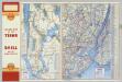
Various Regions and Cities in New Jersey, New York.
Shell Oil Company
Industrial map of New York City : showing manufacturing industries, concentration, distribution, character / prepared by the Industrial Bureau of the Merchants' Association of New York.
from Whole
A plan of New York Island, with part of Long Island, Staten Island & east New Jersey : with a particular description of the engagement on the woody heights of Long Island, between Flatbush and Brooklyn, on the 27th of August 1776 between His Majesty'
from Cartographic materials from the Emmet Collection of Manuscripts Etc. Relating to American History.
The Hudson by daylight map, from New York Bay to the head of tide water : containing names of streams, islands, and heights of mountains according to the latest coast survey : also the names of prominent residences, historic land marks, the old reaches o
from Hudson River
Panorama of the Borough of the Bronx issued by the Bronx Home News.
From Bronx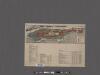
Map of the Borough of Manhattan and part of the Bronx showing location and extent of racial colonies.
From Manhattan
New York City and Vicinity.
1 : 30000 Walling, H. F.
Chart and plan of the harbour of New York & the couny. adjacent, from Sandy Hook to Kingsbridge : comprehending the whole of New York and Staten Islands, and part of Long Island & the Jersey shore, and shewing the defences of New York both by land and se
from Cartographic materials from the Emmet Collection of Manuscripts Etc. Relating to American History.
New map of Kings and Queens counties : from actual Surveys.
From Brooklyn
Coast Chart No. 20 New York Bay And Harbor, New York.
1 : 80000 United States Coast Survey
New York Bay and Harbor, New York.
1 : 126720 United States Coast Survey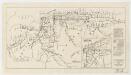
Map showing routes & stations on the dual system October, 1918
1 : 46000 New York (State). Public Service Commission State of New York Public Service Commission for the First District