Maps of Fire Island

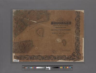
Map of the City of Brooklyn as consolidated by an act of the Legislature of the Ste of New York . . . Constructed from the official maps of the Commissioners . . . Exhibiting the farm lines names of the original owners.
From Brooklyn
Topographical map of New York City, County and vicinity: showing old farm lines &c. / based on Randells and other official surveys, drawings and modern surveys by J.F. Harrison & T. Magrane; printed by C. Wadlow.
from (A-Z) J. F. Harrison; T. Magrane; C. Wadlow,
Topographical map of New York City, County and vicinity: showing old farm lines &c. / based on Randells and other official surveys, drawings and modern surveys by J.F. Harrison & T. Magrane; printed by C. Wadlow.
from (A-Z) J. F. Harrison; T. Magrane; C. Wadlow,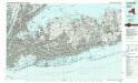
Long Island West
1 : 100000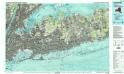
Long Island West
1 : 100000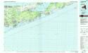
Long Island East
1 : 100000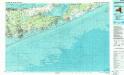
Long Island East
1 : 100000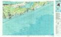
Long Island East
1 : 100000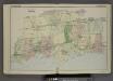
Plan of Town of Islip. [Township]
from Atlas of the towns of Babylon, Islip, and south part of Brookhaven in Suffolk Co., N.Y. Published by Wendelken & Co., 36 Vesey street, New York ... Engraved and printed by L.E. Neuman & Co.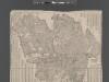
Street Indexed map of the Borough of Queens, also showing the Congressional Districts.
From Queens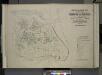
Index map to Vol. 3; Atlas of the Borough of Queens Third Ward city of New York. Published by E. Belcher Hyde; 97 Liberty St., Brooklyn Borough. 1904.
from Third ward: Flushing.
Babylon, Suffolk Co. - Commac, Town of Huntington, Suffolk Co.
from Atlas of Long Island, New York. From recent and actual surveys and records.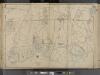
Suffolk County, V. 1, Double Page Plate No. 2 [Map bounded by Town of Smithtown, Bohemia, Nicolls Bay, Great South Bay, Town of Babylon] / supplemented by careful measurements & field observations by our own Corps of Engineers.
From Vol. 1, South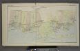
South Part of Brookhaven. [Township]
from Atlas of the towns of Babylon, Islip, and south part of Brookhaven in Suffolk Co., N.Y. Published by Wendelken & Co., 36 Vesey street, New York ... Engraved and printed by L.E. Neuman & Co.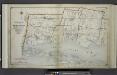
Index Map No.1 of a part of Suffolk County. South Side - Ocean Shore, Long Island. Townships of Babylon and Part of Islip Published by E. Belcher Hyde. 97 Liberty Street, Brooklyn. 5 Beekman Street, Manhattan. 1915. Volume One.
from Atlas of ... Suffolk County, Long Island, New York ... : based upon actual measurements by our own corps of engineers, maps on file at county offices, also maps from actual surveys furnished by individual owners / under the supervision of Merritt B. Hyde.
New York City, County, and vicinity.
From Manhattan
Map of Queens Borough, City of New York.
From Queens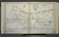
Index Map No.2 of a part of Suffolk County. South Side - Ocean Shore, Long Island. Part of Islip and Part of Brookhaven. Published by E. Belcher Hyde. 97 Liberty Street, Brooklyn. 5 Beekman Street, Manhattan. 1915. Volume One.
from Atlas of ... Suffolk County, Long Island, New York ... : based upon actual measurements by our own corps of engineers, maps on file at county offices, also maps from actual surveys furnished by individual owners / under the supervision of Merritt B. Hyde.
Map of Newtown Long Island. Designed to exhibit the localities referred to in the "Annals of Newtown."
From Queens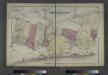
Part of Brookhaven, Suffolk Co.
from Atlas of Long Island, New York. From recent and actual surveys and records.
Index: Borough of Manhattan. Scale 1800 feet to the Inch. LEGEND, [Battery Park - 158th Street].
from Atlas of the city of New York, borough of Manhattan. From actual surveys and official plans / by George W. and Walter S. Bromley.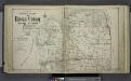
Upper section Index Map of Nassau County Long Island Published by E. Belcher Hype. 97 Liberty St. Brooklyn, 5 Beekman St. Manhattan. 1914.
from Atlas of Nassau County, Long Island, N.Y. Complete in one volume. Historical, statistical. Based upon maps on file at the county seat in Mineola and upon private plans and surveys furnished by surveyors and individual owners. Supplemented by careful measurements & field observations by our own corps of engineers.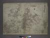
Outline and Index Map of the Borough of Queens, City of New York.
from Atlas of the city of New York, borough of Queens, Long Island City, Newtown, Flushing, Jamaica, Far Rockaway, from actual surveys and official plans / by George W. and Walter S. Bromley.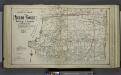
Lower section Index Map of Nassau County Long Island Published by E. Belcher Hype. 97 Liberty St. Brooklyn, 5 Beekman St. Manhattan. 1914.
from Atlas of Nassau County, Long Island, N.Y. Complete in one volume. Historical, statistical. Based upon maps on file at the county seat in Mineola and upon private plans and surveys furnished by surveyors and individual owners. Supplemented by careful measurements & field observations by our own corps of engineers.
Street Indexed map of the Borough of Queens, also showing the Congressional Districts.
From Queens
BLOCK INDEX. Includes the map of Manhattan, Sections 1-8.
from Atlas of the city of New York, Manhattan Island. From actual surveys and official plans / by George W. and Walter S. Bromley.
Outline Map of Large Scale Real Estate Atlases of New York City, Borough of Manhattan.
from Atlas of the city of New York, borough of Manhattan. From actual surveys and official plans / by George W. and Walter S. Bromley.
Outline map of large scale real estate atlases of New York City, Borough of Manhattan.
from Atlas of the city of New York, borough of Manhattan / from actual surveys and official plans by George W. and Walter S. Bromley.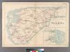
Plate 32: Town of Oyster Bay.
from Atlas of Queens Co., Long Island, New York / compiled from official records, private plans & actual surveys by and under the direction of Chester Wolverton.