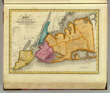
Maps of Long Island

New York, Queens, Kings, Richmond counties.
1 : 158400 Burr, David H., 1803-1875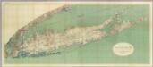
Map Of Long Island, New York.
1 : 125000 U.S. Geological Survey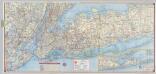
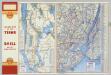
Shell Metropolitan New York and Long Island. Eastern Long Island.
1 : 126720 Shell Oil Company
Map of the City of Brooklyn as consolidated by an act of the Legislature of the Ste of New York . . . Constructed from the official maps of the Commissioners . . . Exhibiting the farm lines names of the original owners.
From Brooklyn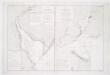
Carte de la baye et riviere de Délaware: contenant une éxacte et entiére description des rivages, criques, havres, sondes, bas-sonds, sables et les gissements des marques les plus considérables du pays depuis les Caps James et May jusqu̕à Philadelphie, suivant la carte originale, publiée en cette ville / par Josué Fischer; Depot de la marine.
from Charts and maps Josué Fischer,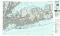
Long Island West
1 : 100000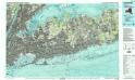
Long Island West
1 : 100000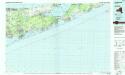
Long Island East
1 : 100000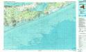
Long Island East
1 : 100000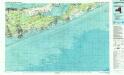
Long Island East
1 : 100000
United States--east coast, New York--New Jersey, New York Harbor / Coast Survey.
United States Coast Survey,
Greater New York's census districts, 1920 : compiled from map prepared 1915-1918 for the 1920 census by the New York Federation of Churches.
From Manhattan
A draught of New York and Perthamboy Harbour.
from Charts and maps
A chart of New York Harbour: with the banks, soundings and sailing marks from the most accurate surveys & observations.
from Charts and maps Printed for Mount and Page?: [London]; Jno. Mount and Tho. Page,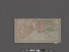
Map of New York City showing portions of Brooklyn, Jersey City, and Westchester Co.
From Manhattan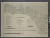
Map of New-York Bay and Harbor and the environs / founded upon a trigonometrical survey under the direction of F. R. Hassler, superintendent of the Survey of the Coast of the United States; triangulation by James Ferguson and Edmund Blunt, assistants; the hydrography under the direction of Thomas R. Gedney, lieutenant U.S. Navy; the topography by C. Renard and T.A. Jenkins assists.
from New York harbor Ferdinand R. Hassler; James Ferguson; Thomas R. Gedney; C. Renard; T.A. Jenkins,
Map of New-York Bay and Harbor and the environs / founded upon a trigonometrical survey under the direction of F.R. Hassler, superintendent of the Survey of the Coast of the United States; triangulation by James Ferguson and Edmund Blunt assistants; the hydrography under the direction of Thomas R. Gedney, lieutenant U.S. Navy; the topography by C. Renard and T.A. Jenkins assists.; verified by C.M. Eakin, assistant.
from New York harbor Ferdinand R. Hassler; James Ferguson; Thomas R. Gedney; C. Renard; T.A. Jenkins; C.M. Eakin,
[A chart of New York Island & North River, East River, passage through Hell Gate, Flushing Bay, Hampstead Bay, Oyster Bay, Huntington Bay, Cow Harbour, East Chester Inlet, Rochelle, Rye, Patrick Islands, &c.]
from Charts and maps
Mass Transit program New York City
From The Borough
Sanitation
From Environment
A plan of the city of New-York & its environs : to Greenwich, on the North or Hudsons River, and to Crown Point, on the East or Sound River, shewing the several streets, publick buildings, docks, fort & battery, with the true form & course of the command
from Charts and maps
Index to Sectional aerial maps of the City of New York / [photographed and assembled under the direction of the chief engineer, July 1st, 1924].
from Sectional aerial maps of the City of New York / [photographed and assembled under the direction of the chief engineer, July 1st, 1924].
Topographical map of New York City, County and vicinity: showing old farm lines &c. / based on Randells and other official surveys, drawings and modern surveys by J.F. Harrison & T. Magrane; printed by C. Wadlow.
from (A-Z) J. F. Harrison; T. Magrane; C. Wadlow,
Topographical map of New York City, County and vicinity: showing old farm lines &c. / based on Randells and other official surveys, drawings and modern surveys by J.F. Harrison & T. Magrane; printed by C. Wadlow.
from (A-Z) J. F. Harrison; T. Magrane; C. Wadlow,