Maps of Debreceni járás

Debreczen.
from Spezialkarte der osterreichisch-ungarischen Monarchie.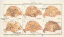
Magyarország mezögazdasági viszonyai
Maďarsko Homolka, Josef Posner Károly Lajos és fia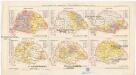
Magyarország népessége hitfelekezetek szerint 1890
Maďarsko Homolka, Josef Posner Károly Lajos és fia
Hortobágy
1 : 240000 Národní park Hortobágy (Maďarsko) Homolka, Josef Posner Károly Lajos és fia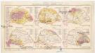
Magyarország népessége anyanyelv szerint
Maďarsko Homolka, Josef Posner Károly Lajos és fia
Hajdu-Szoboszlo und Esztar.
from Spezialkarte der osterreichisch-ungarischen Monarchie.
Nyiregyhaza und Hajdu-Nans.
from Spezialkarte der osterreichisch-ungarischen Monarchie.
Nyir-Beltek und Hajdu-Yamos-Percs.
from Spezialkarte der osterreichisch-ungarischen Monarchie.
Hajdú-Szoboszló
1 : 75000 Hajdúszoboszló, Hajdú-Bihar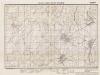
Lambert-Cholesky sheet 2177 (Bagamer)
1 : 20000 Romanian military topographic map sheet under Lambert-Cholensky projection Institutul Geografic Militar geo-spatial.org Institutul Geografic Militar
Debreczen 150, uit: Special-Karte von Mittel-Europa / nach amtlichen Quellen bearbeitet von W. Liebenow
1 : 300000 titelvariant: W. Liebenow's Mittel-Europa; Annotatie: Titel boven de bladen: W. Liebenow's Mittel-Europa Johannes Wilhelm Liebenow 1822-1897 Frankfurt a. M. : Ludwig Ravenstein
Comitat Nord-Bihar
1 : 288000 Debrecín (Maďarsko)
C. Szabolcs
Ungarn Slowakei Komitat Szabolcs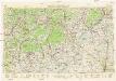
Neubertova generální automapa Republiky československé
1 : 200000 Debrecín (Maďarsko : oblast) Soukup, Jan V. Neubert a synové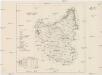
Szabolcser Comitat
1 : 280000 Szabolcs-Szatmár-Bereg (Maďarsko)
Szabolcser Comitat
1 : 280000 Szabolcs-Szatmár-Bereg (Maďarsko)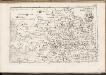
C. Bihariensis. Tab. I
Ungarn Rumänien Komitat Bihar
Nyirecyháza und Hajdú-Nánás
1 : 75000 Hajdúnánás, Umland Geripp: Official K. Höller
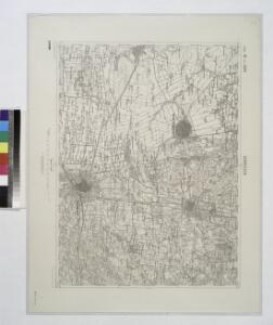
Csege.; Spezialkarte der osterreichisch-ungarischen Monarchie.
from Spezialkarte der osterreichisch-ungarischen Monarchie. Austro-Hungarian Monarchy. Militärgeographisches Institut.,
Szalacs und Bihar-Dioszeg.
from Spezialkarte der osterreichisch-ungarischen Monarchie.
Polgar (Ungarn).
from Spezialkarte der osterreichisch-ungarischen Monarchie.
Puspok-Ladany.; Spezialkarte der osterreichisch-ungarischen Monarchie.
from Spezialkarte der osterreichisch-ungarischen Monarchie. Austro-Hungarian Monarchy. Militärgeographisches Institut.,
Püspök-Ladány
1 : 75000 Püspökladány, Hajdú-Bihar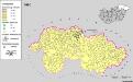
A szlovákok településterülete a szomszédsági mutató alapján Északkelet-Magyarországon 1980-ban
Ungarn (Nordost) Slowaken, Siedlung Bottlik, Zsolt
Partis Hungariae Inter Tibiscum et Nigrum Chrysum Nova et Accurata Descriptio
1 : 530000 Mollova mapová sbírka Valk, Gerhard Schenk, Peter I
Szeged és Debrecen
1 : 750000 Debrecín (Maďarsko : oblast) M. Kir. Állami Térképészet
Rumänen in Ost-Ungarn 1941
Ungarn (Ost) Rumänen, Siedlung Bottlik, Zsolt
Rumänen in Ost-Ungarn 1880
Ungarn (Ost) Rumänen, Siedlung Bottlik, Zsolt
Rumänen in Ost-Ungarn 1980
Ungarn (Ost) Rumänen, Siedlung Bottlik, Zsolt