Maps of Bihor
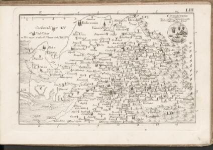
C. Bihariensis. Tab. I
Ungarn Rumänien Komitat Bihar
Hajdu-Szoboszlo und Esztar.
from Spezialkarte der osterreichisch-ungarischen Monarchie.
Szalacs und Bihar-Dioszeg.
from Spezialkarte der osterreichisch-ungarischen Monarchie.
Berettyo-Ujfalu und Koros-Tarjan.
from Spezialkarte der osterreichisch-ungarischen Monarchie.
Szilagy-Somlyo und Elesd.
from Spezialkarte der osterreichisch-ungarischen Monarchie.
Tasnad und Szeplak.
from Spezialkarte der osterreichisch-ungarischen Monarchie.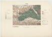
Zone 17, Kol. XXVI, Nagyvárad, uit: [Geologische Specialkarte der im Reichsrathe vertretenen Königreiche und Länder der österreichisch-ungarischen Monarchie] / geologische Aufnahmen der königl. ung. Geologischen Anstalt
1 : 75000 Annotatie: Verantwoordelijkheidsvermelding in 1909 veranderd in: Königliche Ungarische Geologische Reichsanstalt; Sommige bladen in het Frans; Annotatie geografische gegevens: Coördinaten gebaseerd op nulmeridiaan van Ferro (Hierro) Königliche Ungarische Geologische Reichsanstalt; Königliche Ungarische Geologische Anstalt Budapest : [Königliche Ungarische Geologische Anstalt]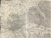
Grosswardein
1 : 75000 Oradea
Tasnád
1 : 75000 Satu-Mare (Judeţ)
16 zóna, XXVII rovat, Tasnád és Széplak Vidéke, uit: [Geologische Specialkarte der im Reichsrathe vertretenen Königreiche und Länder der österreichisch-ungarischen Monarchie] / geologische Aufnahmen der königl. ung. Geologischen Anstalt
1 : 75000 Annotatie: Verantwoordelijkheidsvermelding in 1909 veranderd in: Königliche Ungarische Geologische Reichsanstalt; Sommige bladen in het Frans; Annotatie geografische gegevens: Coördinaten gebaseerd op nulmeridiaan van Ferro (Hierro) Königliche Ungarische Geologische Reichsanstalt; Königliche Ungarische Geologische Anstalt Budapest : [Königliche Ungarische Geologische Anstalt]
Szilágy-Somlyó
1 : 75000 Şimleul-Silvaniei, Umland
Szalacs
1 : 75000 Judeţ Bihor
Hajdú-Szoboszló
1 : 75000 Hajdúszoboszló, Hajdú-Bihar
Grosswarden.; Spezialkarte der osterreichisch-ungarischen Monarchie.
from Spezialkarte der osterreichisch-ungarischen Monarchie. Austro-Hungarian Monarchy. Militärgeographisches Institut.,
N.-Bajom und Szeghalom (Ungarn).
from Spezialkarte der osterreichisch-ungarischen Monarchie.
Puspok-Ladany.; Spezialkarte der osterreichisch-ungarischen Monarchie.
from Spezialkarte der osterreichisch-ungarischen Monarchie. Austro-Hungarian Monarchy. Militärgeographisches Institut.,
N.-Bajom
1 : 75000 Biharnagybajom, Hajdú-Bihar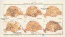
Magyarország mezögazdasági viszonyai
Maďarsko Homolka, Josef Posner Károly Lajos és fia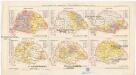
Magyarország népessége hitfelekezetek szerint 1890
Maďarsko Homolka, Josef Posner Károly Lajos és fia
Hortobágy
1 : 240000 Národní park Hortobágy (Maďarsko) Homolka, Josef Posner Károly Lajos és fia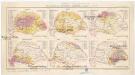
Magyarország népessége anyanyelv szerint
Maďarsko Homolka, Josef Posner Károly Lajos és fia
Püspök-Ladány
1 : 75000 Püspökladány, Hajdú-Bihar
Nagy-Szalonta.
from Spezialkarte der osterreichisch-ungarischen Monarchie.
Tenke und Kardo.
from Spezialkarte der osterreichisch-ungarischen Monarchie.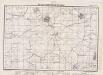
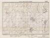
Lambert-Cholesky sheet 1973 (Mezosas)
1 : 20000 Romanian military topographic map sheet under Lambert-Cholensky projection Institutul Geografic Militar geo-spatial.org Institutul Geografic Militar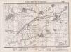
Lambert-Cholesky sheet 1972 (Kumadi)
1 : 20000 Romanian military topographic map sheet under Lambert-Cholensky projection Institutul Geografic Militar geo-spatial.org Institutul Geografic Militar
Lambert-Cholesky sheet 2075 (Pocsaj)
1 : 20000 Romanian military topographic map sheet under Lambert-Cholensky projection Institutul Geografic Militar geo-spatial.org Institutul Geografic Militar
Lambert-Cholesky sheet 1971 (Mezeghian )
1 : 20000 Romanian military topographic map sheet under Lambert-Cholensky projection Serviciul Geografic al Armatei geo-spatial.org Serviciul Geografic al Armatei
Lambert-Cholesky sheet 2074 (Santăul Mare)
1 : 20000 Romanian military topographic map sheet under Lambert-Cholensky projection Direcția Topografică Militară geo-spatial.org Direcția Topografică Militară