Maps of Nádudvar

Puspok-Ladany.; Spezialkarte der osterreichisch-ungarischen Monarchie.
from Spezialkarte der osterreichisch-ungarischen Monarchie. Austro-Hungarian Monarchy. Militärgeographisches Institut.,
Püspök-Ladány
1 : 75000 Püspökladány, Hajdú-Bihar
Debreczen 150, uit: Special-Karte von Mittel-Europa / nach amtlichen Quellen bearbeitet von W. Liebenow
1 : 300000 titelvariant: W. Liebenow's Mittel-Europa; Annotatie: Titel boven de bladen: W. Liebenow's Mittel-Europa Johannes Wilhelm Liebenow 1822-1897 Frankfurt a. M. : Ludwig Ravenstein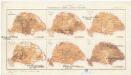
Magyarország mezögazdasági viszonyai
Maďarsko Homolka, Josef Posner Károly Lajos és fia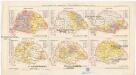
Magyarország népessége hitfelekezetek szerint 1890
Maďarsko Homolka, Josef Posner Károly Lajos és fia
Hortobágy
1 : 240000 Národní park Hortobágy (Maďarsko) Homolka, Josef Posner Károly Lajos és fia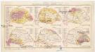
Magyarország népessége anyanyelv szerint
Maďarsko Homolka, Josef Posner Károly Lajos és fia
Comitat Nord-Bihar
1 : 288000 Debrecín (Maďarsko)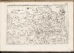
C. Bihariensis. Tab. I
Ungarn Rumänien Komitat Bihar
N.-Bajom und Szeghalom (Ungarn).
from Spezialkarte der osterreichisch-ungarischen Monarchie.
Hajdu-Szoboszlo und Esztar.
from Spezialkarte der osterreichisch-ungarischen Monarchie.
Tisza-Roff.
from Spezialkarte der osterreichisch-ungarischen Monarchie.
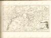
Das Oesterreichische-Kaiserthum

Partis Hungariae Inter Tibiscum et Nigrum Chrysum Nova et Accurata Descriptio
1 : 530000 Mollova mapová sbírka Valk, Gerhard Schenk, Peter I
Szeged és Debrecen
1 : 750000 Debrecín (Maďarsko : oblast) M. Kir. Állami Térképészet
Vermehrte und Verbesserte Landkarten des Königreichs Ungarn :
1 : 500000 Mollova mapová sbírka Stier, Martin Böner, Johann-Alexander Endter, Martin
Die Donau, der Fürst aller Europaeischen Flüsse :
Mollova mapová sbírka Hoffmann, Johannes Hoffmann, Johann
Rumänen in Ost-Ungarn 1941
Ungarn (Ost) Rumänen, Siedlung Bottlik, Zsolt
Rumänen in Ost-Ungarn 1880
Ungarn (Ost) Rumänen, Siedlung Bottlik, Zsolt
Rumänen in Ost-Ungarn 1980
Ungarn (Ost) Rumänen, Siedlung Bottlik, Zsolt
Sheet IX: Karte Des Oesterreichischen Kaiserstaates.
1 : 576000 Scheda, Josef
A rományok aránya és száma Kelet-Magyarországon 1941-ben
Ungarn (Ost) Rumänen, Siedlung Bottlik, Zsolt
A rományok aránya és száma Kelet-Magyarországon 1980-ban
Ungarn (Ost) Rumänen, Siedlung Bottlik, Zsolt
A rományok aránya és száma Kelet-Magyarországon 1880-ban
Ungarn (Ost) Rumänen, Siedlung Bottlik, Zsolt
A Tisavölgy vizszabályozasi átnézeti térképe

Szeged, Nagyvárad, Arad, Erlau, Szolnok
1 : 750000 Arad (Rumunsko) Fendl, J. K. u. k. Militärgeographisches Institut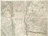
Augustissimo Romanor. Imperatori Iosepho I. Hungaria Regi Invictissimo Mappam Hanc Regni Hungariae
1 : 540000 Mollova mapová sbírka Müller, Johann Christoph
Szegedin, Grosswardein, Ó Arad, Erlau, Szolnok
1 : 750000 Arad (Rumunsko) K. k. militär-geographisches Institut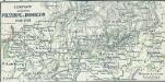
Comitate zwischen Pressburg u. Debreczin 1848, 1849
1 : 2775000 Ungarn Ungarn / Revolution <1848-1849>