Maps of Oxfordshire

Oxonium Comitatus Vulgo Oxford Shire. [Karte], in: Novus atlas absolutissimus, Bd. 7, S. 230.
1 Karte aus Atlas Janssonius Offizin
England & Wales [Bartholomew's "Half-inch to the mile" Map of]
J. Bartholomew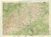
Oxford, Sheet 24 - Bartholomew's "Half Inch to the Mile Maps" of England & Wales
1 : 126720 Topographic maps Bartholomew, John George John Bartholomew & Co
Oxonium Comitatus, Vulgo Oxford Shire. [Karte], in: Theatrum orbis terrarum, sive, Atlas novus, Bd. 4, S. 237.
1 Karte aus Atlas Blaeu, Joan Blaeu, Willem Janszoon
Oxonium Comitatus, Vulgo Oxford Shire. [Karte], in: Le théâtre du monde, ou, Nouvel atlas contenant les chartes et descriptions de tous les païs de la terre, Bd. 4, S. 209.
1 Karte aus Atlas Blaeu, Willem Janszoon und Blaeu, Joan Blaeu, Willem Janszoon
Oxonium Comitatus, Vulgo Oxford Shire. [Karte], in: Theatrum orbis terrarum, sive, Atlas novus, Bd. 4, S. 237.
1 Karte aus Atlas Blaeu, Joan Blaeu, Willem Janszoon
Oxonium Comitatus vulgo Oxford Shire
1 : 220000 [Amstelodami] : [apud Joannem Janssonium]
OXONIVM | Comitatus, Vulgo | OXFORD SHIRE.
Ioh. Blaeu excud.
Oxonium comitatus vulgo Oxford Shire
1 Karte : Kupferdruck ; 36 x 47 cm Valck; Schenk apud Gerardum Valk et Petrum Schenk
Oxonivm comitatus, vulgo Oxford Shire
1 Karte : Kupferdruck ; 37 x 42 cm Blaeu Joan Blaeu
A new improved map of Oxfordshire
1 Karte : Kupferdruck ; 69 x 51 cm Kitchin; Hinton sold by J. Hinton at the Kings Arms in St. Pauls Church Yard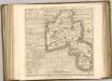

Banbury - OS One-Inch Map
1 : 63360 Topographic maps Ordnance Survey Ordnance Survey
Buckingham - OS One-Inch Map
1 : 63360 Topographic maps Ordnance Survey Ordnance Survey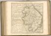

An accurate map of Buckingham Shire
1 Karte : Kupferdruck ; 69 x 52 cm Bowen; Tinney; Bowles; Sayer; Bowles; Bowles sold by I. Tinney at the golden lion and R. Sayer at the golden buck in Fleet street T. Bowles in St. Pauls Church yard and I. Bowles and son in Cornhill
Cheltenham and Evesham - OS One-Inch Map
1 : 63360 Topographic maps Ordnance Survey Ordnance Survey
Stow-on-the-Wold
1 : 31680 The Cotswold Hills dominate the landscape around Stow depicted in this plan. Rising gently from the broad, green meadows of the upper Thames, the hills form a dramatic limestone escarpment above the Severn Valley and Evesham Vale. The Jurassic limestone is widely used as building material throughout the Cotswolds, giving the area its distinctive appearance. Grassland habitats and ancient beech forests are other typical features documented on the plan. Anderson, James
Chipping Camden
1 : 31680 This plan covers parts of Warwickshire and Worcestershire, with the Severn Valley depicted in the middle. The River Avon meanders north-eastwards from Tewkesbury (where it meets the River Severn) to Stratford on Avon, where, after 17 locks, it joins the Stratford-on-Avon Canal. Below the Avon, near the bottom of the sheet, the Cotswolds form a dramatic limestone escarpment above the Severn Valley and Evesham Vale. Jurassic limestone, used as a building material throughout the area, gives the Cotswolds its distinctive look. Dawson, Robert
Towcester
1 : 31680 This drawing covers parts of Northamptonshire, Oxfordshire and Warwickshire. Different types of land use are distinguished symbolically, with relief indicated by brushstroke interlining ('hachuring'). The Watling Street is depicted down the right of the sheet forming the boundary of the surveyed area. This Roman road ran from London to Wroxeter in Wales, via St. Albans and Leicester (where it intersected the Fosse Way, the Roman road from Exeter to Lincoln).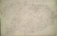
Winslow
1 : 31680 Enclosed farmland characterises the landscape of this part of Buckinghamshire. To the right of the manuscript, a section of the Grand Junction Canal is depicted running from Leighton Buzzard to Fenny Strafford along the River Fosse Valley. Two Roman roads are depicted on the plan: the Watling Street from London to Wroxeter in Wales via St. Albans and Leicester, at top right, and the Akeman Street Way, at lower left. Boyce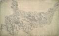
Burford
1 : 31680 In the top right hand corner of the drawing, a red cross marks Chipping Norton Church. This was a base used by the draughtsman for orientation purposes. In 1816, it became obligatory to record archaeological sites on the plans. Here ancient camps are marked at Farmington and near Charlton Abbots. The words "TP Gate" appear on several roads, notably at Wincombe towards the top, indicating a turnpike gate. The accurate and precise record these drawings provide of the road network sets them apart from earlier county maps. Stanley, William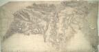
Bicester
1 : 31680 Enclosed farmland dominates the landscape of this part of Oxfordshire. Heythrop Park, at top left, and Middleton Park and Kirtlington Park, in the centre, are fine examples of 17th-century formal park landscapes. Stanley, William
Stony Stratford
1 : 31680 The county boundary of Buckinghamshire and Northamptonshire is depicted to the right of the sheet as a red pecked line. It can be seen following sections of the River Ouse. Two ancient forests are also shown: the Royal Forest of Whittlewood, a medieval hunting forest, is at middle left; and Salcey Forest, the heart of the ancient woodland belt of the East Midlands, is shown at top left. A section of the Watling Street is indicated from bottom left to top right. This ancient Roman road ran from London to Wroxeter in Wales, via St. Albans and Leicester (where it intersected the Fosse Way, the Roman road from Exeter to Lincoln). Boyce
Tring
1 : 31680 This field sketch describes the chalk hills of the Chilterns, including a section of the Grand Junction and the Aylesbury Canals. Some field boundaries on this drawing have been revised and corrected in red ink which suggests they,should be read as accurate delineations plotted from surveyed measurements.,A reservoir,located just above Wendover was also inserted at a later date. , Boyce
Henley-in-Arden
1 : 31680 This plan covers parts of Warwickshire and Worcestershire. Hill contours are described by brushwork interlining ('hachuring') combined with shaded bands of colour wash, which graduate to almost colourless at the summits. The order of ascending heights is expressed by rising numbers, a technique that became known as 'relative command'. Colour washes and symbols distinguish woods, meadows, common and arable land. Dawson, Robert
Northampton
1 : 31680 This drawing covers part of the Nene Valley as the river meanders through farmland and the industries of Northamptonshire. Mills are depicted throughout the area, especially along the river's course. The staples of Northamptonshire's industry at the beginning of the 19th century were wool, lace, silk and shoemaking. With no indigenous coal supply, local industrialists relied principally upon natural resources for industrial processing, particularly wind and water. Hyett, William
Warwick
1 : 31680 This,plan of,part of South Warwickshire shows the broad valley of the River Avon,to the,left of the sheet with the county town,shown at middle left along the riverbank. Major roads are highlighted in buff and feature tollgates and turnpikes along their routes. Turnpike Trusts were,established between the 17th and 19th centuries to raise money from travellers for the upkeep and maintenance of roads. Stevens, Henry