Maps of Oxfordshire
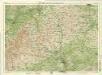
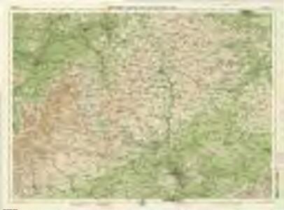
Oxford, Sheet 24 - Bartholomew's "Half Inch to the Mile Maps" of England & Wales
1 : 126720 Topographic maps Bartholomew, John George John Bartholomew & Co
England & Wales [Bartholomew's "Half-inch to the mile" Map of]
J. Bartholomew

OXONIVM | Comitatus, Vulgo | OXFORD SHIRE.
Ioh. Blaeu excud.
Oxonium Comitatus vulgo Oxford Shire
1 : 220000 [Amstelodami] : [apud Joannem Janssonium]
Oxonium comitatus vulgo Oxford Shire
1 Karte : Kupferdruck ; 36 x 47 cm Valck; Schenk apud Gerardum Valk et Petrum Schenk
Oxonivm comitatus, vulgo Oxford Shire
1 Karte : Kupferdruck ; 37 x 42 cm Blaeu Joan Blaeu
A new improved map of Oxfordshire
1 Karte : Kupferdruck ; 69 x 51 cm Kitchin; Hinton sold by J. Hinton at the Kings Arms in St. Pauls Church Yard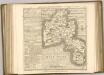

Banbury - OS One-Inch Map
1 : 63360 Topographic maps Ordnance Survey Ordnance Survey
Cheltenham and Evesham - OS One-Inch Map
1 : 63360 Topographic maps Ordnance Survey Ordnance Survey
Buckingham - OS One-Inch Map
1 : 63360 Topographic maps Ordnance Survey Ordnance Survey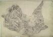
Stow-on-the-Wold
1 : 31680 The Cotswold Hills dominate the landscape around Stow depicted in this plan. Rising gently from the broad, green meadows of the upper Thames, the hills form a dramatic limestone escarpment above the Severn Valley and Evesham Vale. The Jurassic limestone is widely used as building material throughout the Cotswolds, giving the area its distinctive appearance. Grassland habitats and ancient beech forests are other typical features documented on the plan. Anderson, James
Chipping Camden
1 : 31680 This plan covers parts of Warwickshire and Worcestershire, with the Severn Valley depicted in the middle. The River Avon meanders north-eastwards from Tewkesbury (where it meets the River Severn) to Stratford on Avon, where, after 17 locks, it joins the Stratford-on-Avon Canal. Below the Avon, near the bottom of the sheet, the Cotswolds form a dramatic limestone escarpment above the Severn Valley and Evesham Vale. Jurassic limestone, used as a building material throughout the area, gives the Cotswolds its distinctive look. Dawson, Robert
Bicester
1 : 31680 Enclosed farmland dominates the landscape of this part of Oxfordshire. Heythrop Park, at top left, and Middleton Park and Kirtlington Park, in the centre, are fine examples of 17th-century formal park landscapes. Stanley, William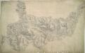
Burford
1 : 31680 In the top right hand corner of the drawing, a red cross marks Chipping Norton Church. This was a base used by the draughtsman for orientation purposes. In 1816, it became obligatory to record archaeological sites on the plans. Here ancient camps are marked at Farmington and near Charlton Abbots. The words "TP Gate" appear on several roads, notably at Wincombe towards the top, indicating a turnpike gate. The accurate and precise record these drawings provide of the road network sets them apart from earlier county maps. Stanley, William
Towcester (Hills) - OS One-Inch Revised New Series
1 : 63360 Topographic maps Ordnance Survey Ordnance Survey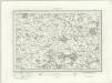
Towcester (Outline) - OS One-Inch Revised New Series
1 : 63360 Topographic maps Ordnance Survey Ordnance Survey
Buckingham (Hills) - OS One-Inch Revised New Series
1 : 63360 Topographic maps Ordnance Survey Ordnance Survey
Buckingham (Outline) - OS One-Inch Revised New Series
1 : 63360 Topographic maps Ordnance Survey Ordnance Survey
Thame (Outline) - OS One-Inch Revised New Series
1 : 63360 Topographic maps Ordnance Survey Ordnance Survey
Thame (Hills) - OS One-Inch Revised New Series
1 : 63360 Topographic maps Ordnance Survey Ordnance Survey
Banbury (Hills) - OS One-Inch Revised New Series
1 : 63360 Topographic maps Ordnance Survey Ordnance Survey
Banbury (Outline) - OS One-Inch Revised New Series
1 : 63360 Topographic maps Ordnance Survey Ordnance Survey
Chipping Norton (Outline) - OS One-Inch Revised New Series
1 : 63360 Topographic maps Ordnance Survey Ordnance Survey
Chipping Norton (Hills) - OS One-Inch Revised New Series
1 : 63360 Topographic maps Ordnance Survey Ordnance Survey
Oxford (Hills) - OS One-Inch Revised New Series
1 : 63360 Topographic maps Ordnance Survey Ordnance Survey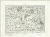
Oxford (Outline) - OS One-Inch Revised New Series
1 : 63360 Topographic maps Ordnance Survey Ordnance Survey
Shipston-on-Stour
1 : 31680 This area at the edge of the Cotswolds is dominated by enclosed farmland. Depicted at top left is the Fosse Way, the old Roman road running from Exeter to Lincoln, via Bath, Cirencester and Leicester (where it intersected the Watling Street from London).
Stratford on Avon (Outline) - OS One-Inch Revised New Series
1 : 63360 Topographic maps Ordnance Survey Ordnance Survey