Maps of Aylesbury Vale

Buckingham - OS One-Inch Map
1 : 63360 Topographic maps Ordnance Survey Ordnance Survey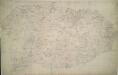
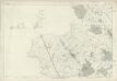
Winslow
1 : 31680 Enclosed farmland characterises the landscape of this part of Buckinghamshire. To the right of the manuscript, a section of the Grand Junction Canal is depicted running from Leighton Buzzard to Fenny Strafford along the River Fosse Valley. Two Roman roads are depicted on the plan: the Watling Street from London to Wroxeter in Wales via St. Albans and Leicester, at top right, and the Akeman Street Way, at lower left. Boyce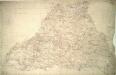
Stony Stratford
1 : 31680 The county boundary of Buckinghamshire and Northamptonshire is depicted to the right of the sheet as a red pecked line. It can be seen following sections of the River Ouse. Two ancient forests are also shown: the Royal Forest of Whittlewood, a medieval hunting forest, is at middle left; and Salcey Forest, the heart of the ancient woodland belt of the East Midlands, is shown at top left. A section of the Watling Street is indicated from bottom left to top right. This ancient Roman road ran from London to Wroxeter in Wales, via St. Albans and Leicester (where it intersected the Fosse Way, the Roman road from Exeter to Lincoln). Boyce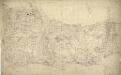
Tring
1 : 31680 This field sketch describes the chalk hills of the Chilterns, including a section of the Grand Junction and the Aylesbury Canals. Some field boundaries on this drawing have been revised and corrected in red ink which suggests they,should be read as accurate delineations plotted from surveyed measurements.,A reservoir,located just above Wendover was also inserted at a later date. , Boyce
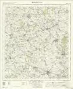
Towcester (Hills) - OS One-Inch Revised New Series
1 : 63360 Topographic maps Ordnance Survey Ordnance Survey
Towcester (Outline) - OS One-Inch Revised New Series
1 : 63360 Topographic maps Ordnance Survey Ordnance Survey
Buckingham (Hills) - OS One-Inch Revised New Series
1 : 63360 Topographic maps Ordnance Survey Ordnance Survey
Buckingham (Outline) - OS One-Inch Revised New Series
1 : 63360 Topographic maps Ordnance Survey Ordnance Survey
Thame (Outline) - OS One-Inch Revised New Series
1 : 63360 Topographic maps Ordnance Survey Ordnance Survey
Thame (Hills) - OS One-Inch Revised New Series
1 : 63360 Topographic maps Ordnance Survey Ordnance Survey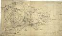
Aylesbury
1 : 31680 The chalk range of the Chiltern Hills reaches its highest point at Combe Hill, near Wendover, at the bottom left of this plan. Roughly drawn interlining ('hachuring') in black depicts relief with a recto inscription in pencil noting that "the irregular pencil lines are drawn too strong". The draughtsman has described earthworks, barrows, minor tributaries and a navigable feeder of the Grand Union Canal and a section of the prehistoric Icknield Way running from above Tring to "Pittlesthorn". Corrections in red ink are clearly visible, possibly dating from the 1831 revision of the plan. Boyce
Worminghall
1 : 31680 The border between Buckinghamshire and Oxfordshire is drawn as a red dashed line along the path of the River Thame, near the bottom of the map., Worminghall is on the Buckinghamshire side of the border., Soft pencil rays criss-cross the map, used by the surveyor when taking measurements between fixed points., These are most clearly visible at 'Brill on the Mill' near the top of the plan. Stanley, William
Towcester
1 : 31680 This drawing covers parts of Northamptonshire, Oxfordshire and Warwickshire. Different types of land use are distinguished symbolically, with relief indicated by brushstroke interlining ('hachuring'). The Watling Street is depicted down the right of the sheet forming the boundary of the surveyed area. This Roman road ran from London to Wroxeter in Wales, via St. Albans and Leicester (where it intersected the Fosse Way, the Roman road from Exeter to Lincoln).
Ot Moor
1 : 31680 .The county border between Oxfordshire and Buckinghamshire is indicated on this map by a red dotted line near the left margin., Ot Moor, an area of some 4,000 acres of fenland, appears at the centre of the drawing., Depicted around the moor are the remains of ancient woodlands: Prattle Woods, Horton Spinney, Studley Wood and Whitecross Green Wood. Stanley, William
Leighton Buzzard (Hills) - OS One-Inch Revised New Series
1 : 63360 Topographic maps Ordnance Survey Ordnance Survey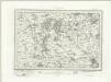
Leighton Buzzard (Outline) - OS One-Inch Revised New Series
1 : 63360 Topographic maps Ordnance Survey Ordnance Survey
SP84 - OS 1:25,000 Provisional Series Map
1 : 25000 Topographic maps Ordnance Survey Ordnance Survey
SP83 - OS 1:25,000 Provisional Series Map
1 : 25000 Topographic maps Ordnance Survey Ordnance Survey
SP82 - OS 1:25,000 Provisional Series Map
1 : 25000 Topographic maps Ordnance Survey Ordnance Survey
SP74 - OS 1:25,000 Provisional Series Map
1 : 25000 Topographic maps Ordnance Survey Ordnance Survey
SP81 - OS 1:25,000 Provisional Series Map
1 : 25000 Topographic maps Ordnance Survey Ordnance Survey
SP73 - OS 1:25,000 Provisional Series Map
1 : 25000 Topographic maps Ordnance Survey Ordnance Survey
SP72 - OS 1:25,000 Provisional Series Map
1 : 25000 Topographic maps Ordnance Survey Ordnance Survey
SP64 - OS 1:25,000 Provisional Series Map
1 : 25000 Topographic maps Ordnance Survey Ordnance Survey
SP71 - OS 1:25,000 Provisional Series Map
1 : 25000 Topographic maps Ordnance Survey Ordnance Survey
SP63 - OS 1:25,000 Provisional Series Map
1 : 25000 Topographic maps Ordnance Survey Ordnance Survey
SP62 - OS 1:25,000 Provisional Series Map
1 : 25000 Topographic maps Ordnance Survey Ordnance Survey
SP61 - OS 1:25,000 Provisional Series Map
1 : 25000 Topographic maps Ordnance Survey Ordnance Survey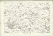
Hertfordshire XXIV (inset XVI) - OS Six-Inch Map
1 : 10560 Topographic maps Ordnance Survey Ordnance Survey