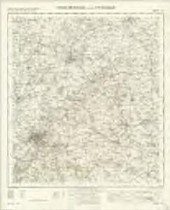
Maps of Milton-under-Wychwood

Cheltenham and Evesham - OS One-Inch Map
1 : 63360 Topographic maps Ordnance Survey Ordnance Survey
Chipping Camden
1 : 31680 This plan covers parts of Warwickshire and Worcestershire, with the Severn Valley depicted in the middle. The River Avon meanders north-eastwards from Tewkesbury (where it meets the River Severn) to Stratford on Avon, where, after 17 locks, it joins the Stratford-on-Avon Canal. Below the Avon, near the bottom of the sheet, the Cotswolds form a dramatic limestone escarpment above the Severn Valley and Evesham Vale. Jurassic limestone, used as a building material throughout the area, gives the Cotswolds its distinctive look. Dawson, Robert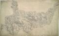
Burford
1 : 31680 In the top right hand corner of the drawing, a red cross marks Chipping Norton Church. This was a base used by the draughtsman for orientation purposes. In 1816, it became obligatory to record archaeological sites on the plans. Here ancient camps are marked at Farmington and near Charlton Abbots. The words "TP Gate" appear on several roads, notably at Wincombe towards the top, indicating a turnpike gate. The accurate and precise record these drawings provide of the road network sets them apart from earlier county maps. Stanley, William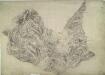
Stow-on-the-Wold
1 : 31680 The Cotswold Hills dominate the landscape around Stow depicted in this plan. Rising gently from the broad, green meadows of the upper Thames, the hills form a dramatic limestone escarpment above the Severn Valley and Evesham Vale. The Jurassic limestone is widely used as building material throughout the Cotswolds, giving the area its distinctive appearance. Grassland habitats and ancient beech forests are other typical features documented on the plan. Anderson, James
Pershore
This plan, covering parts of Worcestershire and Gloucestershire, shows the River Avon Valley near the centre of the sheet. The valley is characterised by meadows and wetlands. Moorings along the river course are indicated between Pershore and Evesham. Dawson, Robert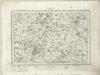
Stratford on Avon (Outline) - OS One-Inch Revised New Series
1 : 63360 Topographic maps Ordnance Survey Ordnance Survey
Stratford on Avon (Hills) - OS One-Inch Revised New Series
1 : 63360 Topographic maps Ordnance Survey Ordnance Survey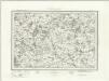
Moreton in the Marsh (Outline) - OS One-Inch Revised New Series
1 : 63360 Topographic maps Ordnance Survey Ordnance Survey
Moreton in the Marsh (Hills) - OS One-Inch Revised New Series
1 : 63360 Topographic maps Ordnance Survey Ordnance Survey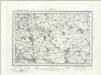
Cirencester (Outline) - OS One-Inch Revised New Series
1 : 63360 Topographic maps Ordnance Survey Ordnance Survey
Cirencester (Hills) - OS One-Inch Revised New Series
1 : 63360 Topographic maps Ordnance Survey Ordnance Survey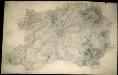
Tewkesbury
1 : 31680 This plan of the Vale of Gloucester is indicative of the draughtman's convention of "relative command": the indication of relative heights of hills by numbers; hill 3 being higher than hill 2, for example. Brushwork interlining ('hachuring') and ink washes further depict relief. Pencil rays intersect across the map, evidence of measurements taken by the surveyor between fixed triangulation points. Archaeological details, such as those at Bredon Hill (at the top right of the plan), are documented even though this did not become obligatory until 1816. The rivers Severn and Leadon and part of the Hereford and Gloucester Canal are described at the bottom left of the map, with Tewkesbury situated centrally at the confluence of the Severn and Upper Avon Rivers. Dawson, Robert
Cheltenham
1 : 31680 This finished plan is attributable to Robert Dawson (1771-1860). The attribution rests on his distinctive portrayal of relief. A dark wash is used for the lowland areas followed by bands of lighter colour, graduating to almost colourless at the top of hills - a technique that produces a strongly three-domensional effect. Black-ink numbers, clearly visible on the high spots, indicate the relative height of the hills: Hill 8 being higher than Hill 5. This method of notating contour, combined with brushwork interlining ('hachuring') drawn to indicate the steepness of relief, precedes the official introduction of contouring on Ordnance Survey maps in 1839-40. Rows of small neat trees depicting orchards proliferate around the Vale of Gloucester, at the top left of this map. Dawson, Robert
SP24 - OS 1:25,000 Provisional Series Map
1 : 25000 Topographic maps Ordnance Survey Ordnance Survey
SP23 - OS 1:25,000 Provisional Series Map
1 : 25000 Topographic maps Ordnance Survey Ordnance Survey
SP22 - OS 1:25,000 Provisional Series Map
1 : 25000 Topographic maps Ordnance Survey Ordnance Survey
SP14 - OS 1:25,000 Provisional Series Map
1 : 25000 Topographic maps Ordnance Survey Ordnance Survey
SP21 - OS 1:25,000 Provisional Series Map
1 : 25000 Topographic maps Ordnance Survey Ordnance Survey
SP13 - OS 1:25,000 Provisional Series Map
1 : 25000 Topographic maps Ordnance Survey Ordnance Survey
SP12 - OS 1:25,000 Provisional Series Map
1 : 25000 Topographic maps Ordnance Survey Ordnance Survey
SO94 - OS 1:25,000 Provisional Series Map
1 : 25000 Topographic maps Ordnance Survey Ordnance Survey
SP04 - OS 1:25,000 Provisional Series Map
1 : 25000 Topographic maps Ordnance Survey Ordnance Survey
SP11 - OS 1:25,000 Provisional Series Map
1 : 25000 Topographic maps Ordnance Survey Ordnance Survey
SO93 - OS 1:25,000 Provisional Series Map
1 : 25000 Topographic maps Ordnance Survey Ordnance Survey
SP03 - OS 1:25,000 Provisional Series Map
1 : 25000 Topographic maps Ordnance Survey Ordnance Survey
SO92 - OS 1:25,000 Provisional Series Map
1 : 25000 Topographic maps Ordnance Survey Ordnance Survey
SP02 - OS 1:25,000 Provisional Series Map
1 : 25000 Topographic maps Ordnance Survey Ordnance Survey
SO91 - OS 1:25,000 Provisional Series Map
1 : 25000 Topographic maps Ordnance Survey Ordnance Survey
SP01 - OS 1:25,000 Provisional Series Map
1 : 25000 Topographic maps Ordnance Survey Ordnance Survey