Maps of Vojvodina

C. Bacsiensis
Ungarn Komitat Bács-Bodrog
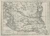
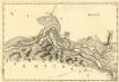
Nieuwe Accurate Kaert van een gedeelte van Hongarie, en Donau Stroom Vertonnende Belgrado en Peter Wardein
1 : 410000 Mollova mapová sbírka Keulen, Gerard van Keyser, Jacob Keulen, Gerard van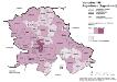
Vojvodina 1981. Jugoslawen (Jugosloveni)
Wojwodina ethnische Gruppe, Jugoslawen Hofinger, Veronika
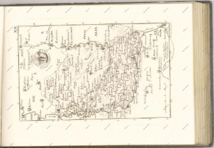
Bács-Bodrog vármegye térképe
1 : 450000 Kogutowicz, Manó Magyar Földrajzi Intézet
Generalkarte von Zentraleuropa
Charte von dem Kanal Franz des zweiten: Nach M. Votésky's Reduction von Ant. Quits Charte der Bácser Gespanschaft
1 : 510000 Landes-Industrie-Comptoir
A horvátok aránya és száma Bács-Kiskun megyében 1941-ben
Bács-Kiskun Kroaten, Siedlung Bottlik, Zsolt
A horvátok aránya és száma Bács-Kiskun megyében 1980-ban
Bács-Kiskun Kroaten, Siedlung Bottlik, Zsolt
A németek településterülete a szomszédsági mutató alapján Bács-Kiskun megyében 1980-ban
Bács-Kiskun Deutsche, Siedlung Bottlik, Zsolt
Subotica
1 : 200000 Subotica (Srbsko) Kartografska radionica
A németek településterülete a szomszédsági mutató alapján Bács-Kiskun megyében 1941-ban
Bács-Kiskun Deutsche, Siedlung Bottlik, Zsolt
A németek településterülete a szomszédsági mutató alapján Bács-Kiskun megyében 1880-ban
Bács-Kiskun Deutsche, Siedlung Bottlik, Zsolt
Siedlungsgebiet der Deutschen nach dem Nachbarschaftsindex für das Komitat Bács-Kiskun 1941
Bács-Kiskun Deutsche, Siedlung Bottlik, Zsolt
Siedlungsgebiet der Deutschen nach dem Nachbarschaftsindex für das Komitat Bács-Kiskun 1880
Bács-Kiskun Deutsche, Siedlung Bottlik, Zsolt
Kroaten im Komitat Bács-Kiskun 1980
Bács-Kiskun Kroaten, Siedlung Bottlik, Zsolt
A horvátok aránya és száma Bács-Kiskun megyében 1880-ban
Bács-Kiskun Kroaten, Siedlung Bottlik, Zsolt
Kroaten im Komitat Bács-Kiskun 1941
Bács-Kiskun Kroaten, Siedlung Bottlik, Zsolt
Kroaten im Komitat Bács-Kiskun 1880
Bács-Kiskun Kroaten, Siedlung Bottlik, Zsolt
Siedlungsgebiet der Deutschen nach dem Nachbarschaftsindex für das Komitat Bács-Kiskun 1980
Bács-Kiskun Deutsche, Siedlung Bottlik, Zsolt
Mitrovica
1 : 200000 Sremska Mitrovica (Srbsko) Kartografska radionica
A Dunavölgy Átnézeti Térképe, Carte d ́ensemble del la Vallée du Danube XVI.
Sectio XI Palancka - Pelagis
Mollova mapová sbírka Marsili, Luigi Ferdinando
Vojvodina 1981, Stadt Novi Sad. Nationalitäten
Novi Sad ethnische Gruppe Hofinger, Veronika
Ilok und Ruma.
from Spezialkarte der osterreichisch-ungarischen Monarchie.
Uj-[Neu]-Verbasz.
from Spezialkarte der osterreichisch-ungarischen Monarchie.
Zombor.
from Spezialkarte der osterreichisch-ungarischen Monarchie.
Vukovar.
from Spezialkarte der osterreichisch-ungarischen Monarchie.
Karlowitz und Titel.
from Spezialkarte der osterreichisch-ungarischen Monarchie.