Maps of West Bačka

Subotica
1 : 200000 Subotica (Srbsko) Kartografska radionica
Zombor.
from Spezialkarte der osterreichisch-ungarischen Monarchie.
Baja.
from Spezialkarte der osterreichisch-ungarischen Monarchie.
Zombor
1 : 75000 Sombor, Wojwodina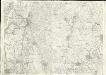
Baja
1 : 75000 Baja
Hajós
1 : 75000 Hajós, Bács-Kiskun
Apatin
1 : 75000 Apatin, Wojwodina
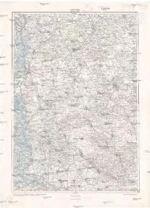
Maria-Theresiopel
1 : 75000 Subotica, Wojwodina
Kis-Kun-Halas
1 : 75000 Kiskunhalas, Bács-Kiskun
Bajmok
1 : 75000 Bajmok, Wojwodina
Uj-Verbász
1 : 75000 Vrbas, Wojwodina
Bajmok und Bacs-Topolya.; Spezialkarte der osterreichisch-ungarischen Monarchie.
from Spezialkarte der osterreichisch-ungarischen Monarchie. Austro-Hungarian Monarchy. Militärgeographisches Institut.,
Maria-Theresiopel.; Spezialkarte der osterreichisch-ungarischen Monarchie.
from Spezialkarte der osterreichisch-ungarischen Monarchie. Austro-Hungarian Monarchy. Militärgeographisches Institut.,
Hajos.
from Spezialkarte der osterreichisch-ungarischen Monarchie.
Kis-Kun-Halas.
from Spezialkarte der osterreichisch-ungarischen Monarchie.
Apatin und Erdut.
from Spezialkarte der osterreichisch-ungarischen Monarchie.
Uj-[Neu]-Verbasz.
from Spezialkarte der osterreichisch-ungarischen Monarchie.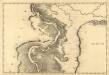
Colotscha - Fulna
Mollova mapová sbírka Marsili, Luigi Ferdinando
C. Bacsiensis
Ungarn Komitat Bács-Bodrog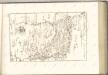

Bács-Bodrog vármegye térképe
1 : 450000 Kogutowicz, Manó Magyar Földrajzi Intézet
Generalkarte von Zentraleuropa

Siedlungsgebiet der Deutschen nach dem Nachbarschaftsindex für das Komitat Bács-Kiskun 1880
Bács-Kiskun Deutsche, Siedlung Bottlik, Zsolt
Kroaten im Komitat Bács-Kiskun 1880
Bács-Kiskun Kroaten, Siedlung Bottlik, Zsolt
Kroaten im Komitat Bács-Kiskun 1980
Bács-Kiskun Kroaten, Siedlung Bottlik, Zsolt
Siedlungsgebiet der Deutschen nach dem Nachbarschaftsindex für das Komitat Bács-Kiskun 1980
Bács-Kiskun Deutsche, Siedlung Bottlik, Zsolt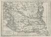
Charte von dem Kanal Franz des zweiten: Nach M. Votésky's Reduction von Ant. Quits Charte der Bácser Gespanschaft
1 : 510000 Landes-Industrie-Comptoir
Mappa Comitatus Solthensis
1 : 170000 Mollova mapová sbírka Mikoviny, Sámuel Schmutzer, Andreas
A Dunavölgy Átnézeti Térképe, Carte d ́ensemble del la Vallée du Danube XVI.