Maps of Juno-Backi

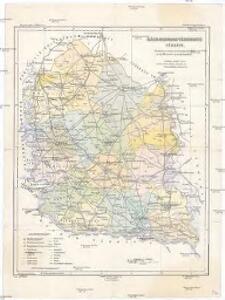
Bács-Bodrog vármegye térképe
1 : 450000 Kogutowicz, Manó Magyar Földrajzi Intézet
Generalkarte von Zentraleuropa
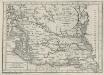
Charte von dem Kanal Franz des zweiten: Nach M. Votésky's Reduction von Ant. Quits Charte der Bácser Gespanschaft
1 : 510000 Landes-Industrie-Comptoir
Subotica
1 : 200000 Subotica (Srbsko) Kartografska radionica
Segedin
1 : 200000 Szeged (Maďarsko) Kartografska radionica
Uj-[Neu]-Verbasz.
from Spezialkarte der osterreichisch-ungarischen Monarchie.
Torokbecse.
from Spezialkarte der osterreichisch-ungarischen Monarchie.
Torokkanizsa.
from Spezialkarte der osterreichisch-ungarischen Monarchie.
Neusatz und Peterwarden.
from Spezialkarte der osterreichisch-ungarischen Monarchie.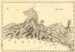
Sectio XI Palancka - Pelagis
Mollova mapová sbírka Marsili, Luigi Ferdinando
Bajmok
1 : 75000 Bajmok, Wojwodina
Maria-Theresiopel
1 : 75000 Subotica, Wojwodina
Törökkanizsa
1 : 75000 Novi Kneževac, Wojwodina
Német-Palánka und Kulpin
1 : 75000 Bačka Palanka Geripp: Korpl. Schneider. Terrain: R. Bloschitz
Neusatz und Peterwardein
1 : 75000 Novi Sad, Petrovaradin Geripp: Fwkr. Rohn. Terrain: Hptm. Stephanie
Törökbecse
1 : 75000 Novi Bečej Geripp: Fwkr. Rohn. Terrain: Leut. Tschofen
Uj-Verbász
1 : 75000 Vrbas, Wojwodina
Zenta
1 : 75000 Senta (Wojwodina)
Nemet-Palanka und Kulpin.; Spezialkarte der osterreichisch-ungarischen Monarchie.
from Spezialkarte der osterreichisch-ungarischen Monarchie. Austro-Hungarian Monarchy. Militärgeographisches Institut.,
Zenta und Ada.; Spezialkarte der osterreichisch-ungarischen Monarchie.
from Spezialkarte der osterreichisch-ungarischen Monarchie. Austro-Hungarian Monarchy. Militärgeographisches Institut.,
Bajmok und Bacs-Topolya.; Spezialkarte der osterreichisch-ungarischen Monarchie.
from Spezialkarte der osterreichisch-ungarischen Monarchie. Austro-Hungarian Monarchy. Militärgeographisches Institut.,
Maria-Theresiopel.; Spezialkarte der osterreichisch-ungarischen Monarchie.
from Spezialkarte der osterreichisch-ungarischen Monarchie. Austro-Hungarian Monarchy. Militärgeographisches Institut.,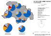
Vojvodina 1981, Stadt Novi Sad. Nationalitäten
Novi Sad ethnische Gruppe Hofinger, Veronika
Kistelek und Szeged.
from Spezialkarte der osterreichisch-ungarischen Monarchie.
Kis-Kun-Halas.
from Spezialkarte der osterreichisch-ungarischen Monarchie.
Zombor.
from Spezialkarte der osterreichisch-ungarischen Monarchie.
Apatin und Erdut.
from Spezialkarte der osterreichisch-ungarischen Monarchie.
Baja.
from Spezialkarte der osterreichisch-ungarischen Monarchie.
Vukovar.
from Spezialkarte der osterreichisch-ungarischen Monarchie.