Maps of Srem District

Mitrovica
1 : 200000 Sremska Mitrovica (Srbsko) Kartografska radionica
Mitrowitz.
from Spezialkarte der osterreichisch-ungarischen Monarchie.
Ilok und Ruma.
from Spezialkarte der osterreichisch-ungarischen Monarchie.
Jamena und Bijeljina.
from Spezialkarte der osterreichisch-ungarischen Monarchie.
Sarengrad und Batrovci.
from Spezialkarte der osterreichisch-ungarischen Monarchie.
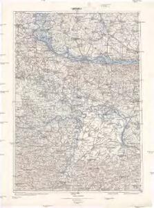
Mitrovica / Mitrowitz
1 : 75000 Sremska Mitrovica Geripp: J. Depisch u. Offiz. W. Ahl. Terrain: Hptm. Stephanie
Jamena und Bijeljina
1 : 75000 Bijeljina, Šid, Gemeindegebiet
Šarengrad und Batrovci
1 : 75000 Šid, Bezirk Vukovar-Sirmien, Gemeindegebiet Geripp: Feldw. Niessner. Terrain: Adolf Hertel
Ilok und Ruma
1 : 75000 Ilok, Ruma Geripp: J. Fitz. Terrain: Oblt. Karl Radler
Nemet-Palanka und Kulpin.; Spezialkarte der osterreichisch-ungarischen Monarchie.
from Spezialkarte der osterreichisch-ungarischen Monarchie. Austro-Hungarian Monarchy. Militärgeographisches Institut.,
Vukovar
1 : 75000 Vukovar Geripp: Fwkr. J. Suchánek. Terrain: Wachtmstr. Rud. v. Palitschek
Német-Palánka und Kulpin
1 : 75000 Bačka Palanka Geripp: Korpl. Schneider. Terrain: R. Bloschitz
Vukovar.
from Spezialkarte der osterreichisch-ungarischen Monarchie.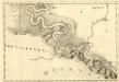
Vrangos - Palancka
Mollova mapová sbírka Marsili, Luigi Ferdinando
Prnjavor.; Spezialkarte der osterreichisch-ungarischen Monarchie.
from Spezialkarte der osterreichisch-ungarischen Monarchie. Austro-Hungarian Monarchy. Militärgeographisches Institut.,
Prnjavor
1 : 75000 Bezirk Srem Geripp: Offiz. J. Rogozinski. Terrain: Hptm. A. Kruliš
Plan v. Schabacz, nach einem handschriftlichen Entwurf in Karlowicz, ohne Jahr, Ufen., der mir aber von dem letzten türkischen Krieg, also 1788 gemacht u. zu seyn scheint, mir einer Liste von 100 Dörfern in den Districten Pod-Cerje, Tamlawa, am Savstrom aber aus und Máčwa
Šabac (Srbsko) Stieler, Adolf Ausfeld, Johann Carl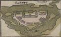
Sabatz
Šabac Stadtbefestigung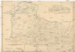
Sitvations-Plan des ganzen Šabacer und eines Theils des Waljewer Districts
1 : 77000 Valjevo (Srbsko) Guretzki von Kornitz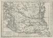
Charte von dem Kanal Franz des zweiten: Nach M. Votésky's Reduction von Ant. Quits Charte der Bácser Gespanschaft
1 : 510000 Landes-Industrie-Comptoir
Carte der Besitznehmung von Lesenitza, Lipanitza, Losenitza gegen Zwornick und Zokol von den K.K. Tr
1 Karte : Kupferdruck ; 12 x 17 cm [Trattner]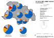
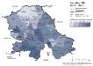
Vojvodina 1981, Stadt Novi Sad. Nationalitäten
Novi Sad ethnische Gruppe Hofinger, Veronika
Janja.
from Spezialkarte der osterreichisch-ungarischen Monarchie.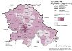
Vojvodina 1981. Jugoslawen (Jugosloveni)
Wojwodina ethnische Gruppe, Jugoslawen Hofinger, Veronika
Tabula Geographica Nova Et Exacta Distincte Exhibens Regnum Sclavoniae Cum Syrmii Ducatu Quod A Fluvus Savi Illovae Dravi Et Danubii Allitur Eius Provinitiae Conterminae Sunt Regnum Hungariae Croatiae Bosniae Serviae Et Bannatus Temesvrensis
Sirmien, Bosnien, Požarevac / Friede Khevenhüller-Frankenburg, Ludwig Andreas von, http://d-nb.info/gnd/116153849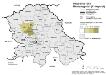
Vojvodina 1981. Montenegriner (Crnogorci)
Wojwodina ethnische Gruppe, Montenegriner Hofinger, Veronika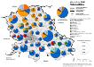
Vojvodina 1981. Nationalitäten
Wojwodina ethnische Gruppe Hofinger, Veronika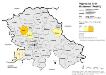
Vojvodina 1981. Ruthenen (Rusini)
Wojwodina ethnische Gruppe, Russinen Hofinger, Veronika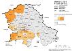
Vojvodina 1981. Kroaten (Hrvati)
Wojwodina ethnische Gruppe, Kroaten Hofinger, Veronika