Maps of Worcestershire

Map of Worcestershire
This is a manuscript map of Worcestershire. The date and draughtsman are not known. It forms part of an atlas that belonged to William Cecil Lord Burghley, Elizabeth I’s Secretary of State. Burghley used this atlas to illustrate domestic matters. The dominant features of the landscape are the waterways and the parks which are shown by symbols of fenced enclosures. These were of central importance to any military campaign. The fastest way to move a lot of men and weaponry was by river and parks provided somewhere for troops to set up camp and for horses to graze. Lord Burghley has annotated the map. In the left margin he has added a list of residents of the area and what lands and properties they are associated with, inserting some of these into the map itself. This is a good indication of how detailed was the knowledge accumulated by Burghley. William Cecil, Lord Burghley
Wigorniensis Comitatus cum Warwicensi; nec non Conventriae Libertas. [Karte], in: Novus atlas absolutissimus, Bd. 7, S. 342.
1 Karte aus Atlas Janssonius Offizin
WIGORNIENSIS | Comitatus et Comitatus | WARWICENSIS| nec non | COVENTRÆ LIBERTAS | WORCESTER, WARWIK SHIRE. | and THE LIBERTY OF COVENTRE.
[Amsterdam : Joan Blaeu]
VIGORNIENSIS Comitatus Sheet 21
This map of Worcestershire is from the 1583 edition of the Saxton atlas of England and Wales.This atlas was first published as a whole in 1579. It consists of 35 coloured maps depicting the counties of England and Wales. The atlas is of great significance to British cartography as it set a standard of cartographic representation in Britain and the maps remained the basis for English county mapping, with few exceptions, until after 1750. During the reign of Elizabeth I map use became more common, with many government matters referring to increasingly accurate maps with consistent scales and symbols, made possible by advances in surveying techniques. Illustrating the increasing used of maps in government matters, Lord Burghley, Elizabeth I’s Secretary of State, who had been determined to have England and Wales mapped in detail from the 1550s, selected the cartographer Christopher Saxton to produce a detailed and consistent survey of the country. The financier of the project was Thomas Seckford Master of Requests at the Court of Elizabeth I, whose arms appear, along with the royal crest, on each map. Saxton, Christopher Ryther, Augustine
Wigorniensis Comitatus cum Warwicensi, nec non Conventriae Libertas
1 : 180000 Amstelodami : apud Joannem Janssonium
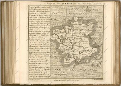
An accurate map of the county of Worcester
1 Karte : Kupferdruck ; 51 x 68 cm Bowen; Tinney; Bowles; Sayer; Bowles; Bowles sold by I. Tinney at the Golden Lion and R. Sayer at the Golden Buck in Fleet street T. Bowles in St. Pauls Church Yard and I. Bowles and son at the Black Horse in Cornhill
Wigorniensis comitatus et comitatus Warwicensis; nec non Coventræ libertas
1 Karte : Kupferdruck ; 40 x 48 cm Blaeu Joan Blaeu
Sheets 31-32. (Cary's England, Wales, and Scotland).
1 : 360000 Cary, John, ca. 1754-1835
Kidderminster - OS One-Inch Map
1 : 63360 Topographic maps Ordnance Survey Ordnance Survey
Gloucester and Malvern - OS One-Inch Map
1 : 63360 Topographic maps Ordnance Survey Ordnance Survey
Birmingham - OS One-Inch Map
1 : 63360 Topographic maps Ordnance Survey Ordnance Survey
Cheltenham and Evesham - OS One-Inch Map
1 : 63360 Topographic maps Ordnance Survey Ordnance Survey
Ordnance Survey of England. Sheet 168, Birmingham
1 : 63360 Ordnance survey. GB Southampton : Ordnance Survey Office
Actual survey of the county of Salop, 4
1 Blatt : 71 x 53 cm John Rocque
Actual Survey of the County of Salop
Rocque, John
Tewkesbury
1 : 31680 This plan of the Vale of Gloucester is indicative of the draughtman's convention of "relative command": the indication of relative heights of hills by numbers; hill 3 being higher than hill 2, for example. Brushwork interlining ('hachuring') and ink washes further depict relief. Pencil rays intersect across the map, evidence of measurements taken by the surveyor between fixed triangulation points. Archaeological details, such as those at Bredon Hill (at the top right of the plan), are documented even though this did not become obligatory until 1816. The rivers Severn and Leadon and part of the Hereford and Gloucester Canal are described at the bottom left of the map, with Tewkesbury situated centrally at the confluence of the Severn and Upper Avon Rivers. Dawson, Robert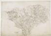
Bridgenorth
1 : 31680 This plan covers East Shropshire and part of Staffordshire, with the River Severn Valley depicted down the left side of the sheet. Here, in its middle course, the river becomes deeper and wider, forming a floodplain in which crops such as wheat and barley are grown. Down the right side of the plan is a section of the Staffordshire and Worcestershire Canal, built by the canal engineer, James Brindley as part of his 'Grand Cross', a farsighted scheme to link the ports of Hull, Liverpool and Bristol by connecting the rivers Mersey, Trent and Severn. The canal opened in May 1772. Ironbridge on the Severn at the top left of the plan is said to be the birthplace of the Industrial Revolution. This tiny town gave the world its first iron bridge in 1779. Dawson, Robert
Wolverhampton 10
1 : 31680 This plan covers part of the English Midland plateau. The Staffordshire and Worcestershire Canal is depicted down the left side. Opened for traffic in May 1772, the canal was built by engineer James Brindley as part of his 'Grand Cross', a far-sighted scheme to link the ports of Hull, Liverpool and Bristol by connecting the rivers Mersey, Trent and Severn. Work on a second waterway, the Birmingham Canal, started a year later to facilitate the transport of coal from the pits of the Black Country to Birmingham. The Industrial Revolution saw over 180 miles of canals and 216 locks built. Part of this network is visible on the plan highlighted in blue. Dawson, Robert

Pershore
This plan, covering parts of Worcestershire and Gloucestershire, shows the River Avon Valley near the centre of the sheet. The valley is characterised by meadows and wetlands. Moorings along the river course are indicated between Pershore and Evesham. Dawson, Robert
Birmingham (Hills) - OS One-Inch Revised New Series
1 : 63360 Topographic maps Ordnance Survey Ordnance Survey
Birmingham (Outline) - OS One-Inch Revised New Series
1 : 63360 Topographic maps Ordnance Survey Ordnance Survey
Redditch (Hills) - OS One-Inch Revised New Series
1 : 63360 Topographic maps Ordnance Survey Ordnance Survey
Redditch (Outline) - OS One-Inch Revised New Series
1 : 63360 Topographic maps Ordnance Survey Ordnance Survey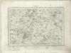
Stratford on Avon (Outline) - OS One-Inch Revised New Series
1 : 63360 Topographic maps Ordnance Survey Ordnance Survey
Stratford on Avon (Hills) - OS One-Inch Revised New Series
1 : 63360 Topographic maps Ordnance Survey Ordnance Survey
Moreton in the Marsh (Outline) - OS One-Inch Revised New Series
1 : 63360 Topographic maps Ordnance Survey Ordnance Survey
Moreton in the Marsh (Hills) - OS One-Inch Revised New Series
1 : 63360 Topographic maps Ordnance Survey Ordnance Survey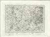
Dudley (Outline) - OS One-Inch Revised New Series
1 : 63360 Topographic maps Ordnance Survey Ordnance Survey