Maps of Dawley Hamlets
Bridgenorth
1 : 31680 This plan covers East Shropshire and part of Staffordshire, with the River Severn Valley depicted down the left side of the sheet. Here, in its middle course, the river becomes deeper and wider, forming a floodplain in which crops such as wheat and barley are grown. Down the right side of the plan is a section of the Staffordshire and Worcestershire Canal, built by the canal engineer, James Brindley as part of his 'Grand Cross', a farsighted scheme to link the ports of Hull, Liverpool and Bristol by connecting the rivers Mersey, Trent and Severn. The canal opened in May 1772. Ironbridge on the Severn at the top left of the plan is said to be the birthplace of the Industrial Revolution. This tiny town gave the world its first iron bridge in 1779. Dawson, Robert
Dudley (Outline) - OS One-Inch Revised New Series
1 : 63360 Topographic maps Ordnance Survey Ordnance Survey
Dudley (Hills) - OS One-Inch Revised New Series
1 : 63360 Topographic maps Ordnance Survey Ordnance Survey
SO69 - OS 1:25,000 Provisional Series Map
1 : 25000 Topographic maps Ordnance Survey Ordnance Survey
SO79 - OS 1:25,000 Provisional Series Map
1 : 25000 Topographic maps Ordnance Survey Ordnance Survey
SO89 - OS 1:25,000 Provisional Series Map
1 : 25000 Topographic maps Ordnance Survey Ordnance Survey
Staffordshire LV - OS Six-Inch Map
1 : 10560 Topographic maps Ordnance Survey Ordnance Survey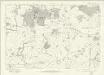
Staffordshire LXI - OS Six-Inch Map
1 : 10560 Topographic maps Ordnance Survey Ordnance Survey
Staffordshire LXVI - OS Six-Inch Map
1 : 10560 Topographic maps Ordnance Survey Ordnance Survey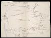
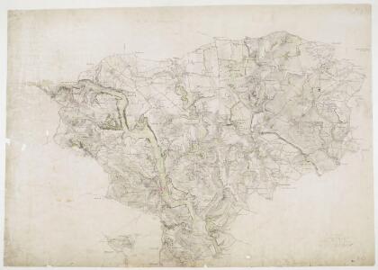
Foresta de Morfe, [Shropshire?]
This is a map of the "Forresta de Morfe", Shropshire(?). It is a simple pen and ink drawing whose intention seems to be to record the extent to which the neighbouring villages lie on forest land, presumably so that any further encroachment and claim to forest land can be refuted. It is annotated with "All the villages herein named be commoners in the said forest". A path through the forest is marked, houses are indicated with a generic symbol and churches are distinguished. Cardinal points are indicated. Maps such as this one of a small locality, drawn to illustrate a particular situation with regards to land boundaries and ownership is an invention of the later 16th century and illustrates how map use was developing to fulfil a practical function, contrasting with the symbolic and religious function of maps in the previous centuries. William Cecil, Lord Burghley
SJ60 - OS 1:25,000 Provisional Series Map
1 : 25000 Topographic maps Ordnance Survey Ordnance Survey
SJ70 - OS 1:25,000 Provisional Series Map
1 : 25000 Topographic maps Ordnance Survey Ordnance Survey
SJ80 - OS 1:25,000 Provisional Series Map
1 : 25000 Topographic maps Ordnance Survey Ordnance Survey
SO88 - OS 1:25,000 Provisional Series Map
1 : 25000 Topographic maps Ordnance Survey Ordnance Survey
SO78 - OS 1:25,000 Provisional Series Map
1 : 25000 Topographic maps Ordnance Survey Ordnance Survey
SO68 - OS 1:25,000 Provisional Series Map
1 : 25000 Topographic maps Ordnance Survey Ordnance Survey
Shropshire XLV.SW - OS Six-Inch Map
1 : 10560 Topographic maps Ordnance Survey Ordnance Survey
Shropshire XLV.SW - OS Six-Inch Map
1 : 10560 Topographic maps Ordnance Survey Ordnance Survey
Shropshire XLV.SW - OS Six-Inch Map
1 : 10560 Topographic maps Ordnance Survey Ordnance Survey
Shropshire LIIa.NW - OS Six-Inch Map
1 : 10560 Topographic maps Ordnance Survey Ordnance Survey
Shropshire LIIa.NW - OS Six-Inch Map
1 : 10560 Topographic maps Ordnance Survey Ordnance Survey
Shropshire XLIV.SE - OS Six-Inch Map
1 : 10560 Topographic maps Ordnance Survey Ordnance Survey
Shropshire XLIV.SE - OS Six-Inch Map
1 : 10560 Topographic maps Ordnance Survey Ordnance Survey
Shropshire XLIV.SE - OS Six-Inch Map
1 : 10560 Topographic maps Ordnance Survey Ordnance Survey
Shropshire LII.NE - OS Six-Inch Map
1 : 10560 Topographic maps Ordnance Survey Ordnance Survey
Shropshire LII.NE - OS Six-Inch Map
1 : 10560 Topographic maps Ordnance Survey Ordnance Survey
Shropshire LII.SE - OS Six-Inch Map
1 : 10560 Topographic maps Ordnance Survey Ordnance Survey
Shropshire LII.SE - OS Six-Inch Map
1 : 10560 Topographic maps Ordnance Survey Ordnance Survey
Shropshire LIX.NE - OS Six-Inch Map
1 : 10560 Topographic maps Ordnance Survey Ordnance Survey
Shropshire LIX.NE - OS Six-Inch Map
1 : 10560 Topographic maps Ordnance Survey Ordnance Survey