Maps of Wyre Forest

Actual survey of the county of Salop, 4
1 Blatt : 71 x 53 cm John Rocque
Actual Survey of the County of Salop
Rocque, John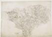
Bridgenorth
1 : 31680 This plan covers East Shropshire and part of Staffordshire, with the River Severn Valley depicted down the left side of the sheet. Here, in its middle course, the river becomes deeper and wider, forming a floodplain in which crops such as wheat and barley are grown. Down the right side of the plan is a section of the Staffordshire and Worcestershire Canal, built by the canal engineer, James Brindley as part of his 'Grand Cross', a farsighted scheme to link the ports of Hull, Liverpool and Bristol by connecting the rivers Mersey, Trent and Severn. The canal opened in May 1772. Ironbridge on the Severn at the top left of the plan is said to be the birthplace of the Industrial Revolution. This tiny town gave the world its first iron bridge in 1779. Dawson, Robert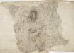
Cleobury Mortimer
1 : 31680 The two smooth humps of Brown Clee Hill dominate the landscape east of Ludlow. With its summit rising to 1,772 ft, Brown Clee is the highest point in Shropshire and was,an iron-age settlement, hosting three hillforts.,Below Brown Clee, the plan shows another isolated hill fort at Titterstone Clee.,At an altitude of,1,750 ft,,this fort is one of the highest and largest in Britain. , Stevens, Henry
Kidderminster
1 : 31680 This plan covers North Worcestershire and parts of Shropshire and Staffordshire. The draughtsman used different shades of green wash to distinguish woods, meadows, commons and parks. The Severn Valley extends down the left-hand side of the map, with the royal hunting forest of Wyre depicted at middle-left. To the right of the sheet is the Stour Valley, with the Staffordshire and Worcestershire Canal following the river valley. Rising above the two valleys is the ancient settlement of Kinver Edge, with its outcrops of red weathering sandstone formed in the Triassic age. Stevens, Henry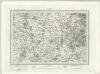
Dudley (Outline) - OS One-Inch Revised New Series
1 : 63360 Topographic maps Ordnance Survey Ordnance Survey
Dudley (Hills) - OS One-Inch Revised New Series
1 : 63360 Topographic maps Ordnance Survey Ordnance Survey
SO69 - OS 1:25,000 Provisional Series Map
1 : 25000 Topographic maps Ordnance Survey Ordnance Survey
SO68 - OS 1:25,000 Provisional Series Map
1 : 25000 Topographic maps Ordnance Survey Ordnance Survey
SO67 - OS 1:25,000 Provisional Series Map
1 : 25000 Topographic maps Ordnance Survey Ordnance Survey
SO79 - OS 1:25,000 Provisional Series Map
1 : 25000 Topographic maps Ordnance Survey Ordnance Survey
SO78 - OS 1:25,000 Provisional Series Map
1 : 25000 Topographic maps Ordnance Survey Ordnance Survey
SO77 - OS 1:25,000 Provisional Series Map
1 : 25000 Topographic maps Ordnance Survey Ordnance Survey
Foresta de Morfe, [Shropshire?]
This is a map of the "Forresta de Morfe", Shropshire(?). It is a simple pen and ink drawing whose intention seems to be to record the extent to which the neighbouring villages lie on forest land, presumably so that any further encroachment and claim to forest land can be refuted. It is annotated with "All the villages herein named be commoners in the said forest". A path through the forest is marked, houses are indicated with a generic symbol and churches are distinguished. Cardinal points are indicated. Maps such as this one of a small locality, drawn to illustrate a particular situation with regards to land boundaries and ownership is an invention of the later 16th century and illustrates how map use was developing to fulfil a practical function, contrasting with the symbolic and religious function of maps in the previous centuries. William Cecil, Lord Burghley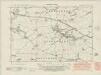
Shropshire XLIV.SE - OS Six-Inch Map
1 : 10560 Topographic maps Ordnance Survey Ordnance Survey
Shropshire XLIV.SE - OS Six-Inch Map
1 : 10560 Topographic maps Ordnance Survey Ordnance Survey
Shropshire XLIV.SE - OS Six-Inch Map
1 : 10560 Topographic maps Ordnance Survey Ordnance Survey
Shropshire LII.NE - OS Six-Inch Map
1 : 10560 Topographic maps Ordnance Survey Ordnance Survey
Shropshire LII.NE - OS Six-Inch Map
1 : 10560 Topographic maps Ordnance Survey Ordnance Survey
Shropshire LII.SE - OS Six-Inch Map
1 : 10560 Topographic maps Ordnance Survey Ordnance Survey
Shropshire LII.SE - OS Six-Inch Map
1 : 10560 Topographic maps Ordnance Survey Ordnance Survey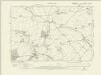
Shropshire LIX.NE - OS Six-Inch Map
1 : 10560 Topographic maps Ordnance Survey Ordnance Survey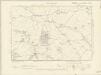
Shropshire LIX.NE - OS Six-Inch Map
1 : 10560 Topographic maps Ordnance Survey Ordnance Survey
Shropshire LIX.NE - OS Six-Inch Map
1 : 10560 Topographic maps Ordnance Survey Ordnance Survey
Shropshire XLIV.SW - OS Six-Inch Map
1 : 10560 Topographic maps Ordnance Survey Ordnance Survey
Shropshire XLIV.SW - OS Six-Inch Map
1 : 10560 Topographic maps Ordnance Survey Ordnance Survey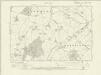
Shropshire LIX.SE - OS Six-Inch Map
1 : 10560 Topographic maps Ordnance Survey Ordnance Survey
Shropshire LIX.SE - OS Six-Inch Map
1 : 10560 Topographic maps Ordnance Survey Ordnance Survey
Shropshire LIX.SE - OS Six-Inch Map
1 : 10560 Topographic maps Ordnance Survey Ordnance Survey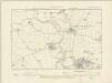
Shropshire LII.NW - OS Six-Inch Map
1 : 10560 Topographic maps Ordnance Survey Ordnance Survey


