Maps of Tamanghasset


Northern Nigeria: Native Authority Areas

Map of the Colony and Protectorate of Nigeria 1929. Drawn and reproduced by the Nigeria Surveys March 1929
Nigeria Surveys
West Africa.
1 : 2500000 Andree, Richard; Times (London, England)
The River Niger.
1 : 3400000 Arrowsmith, John
Algérie, Tunisie et Sahara central, pour servir particulièrement à l'intelligence des évenements actuels et notamment à suivre les deux explorations du colonel Flatters
1 : 5000000 Barbier, Joseph-Victor 1840-1898 Nancy : Albert Barbier
Nigeria (1907)
Outline map of Northern and Southern Nigeria, TSGS 2235. Shows major rivers, railways, boundaries and towns. Great Britain. General Staff. Topographical Section. [London] : [TSGS, War Office]
Kolonien (Schutzgebiete) des Deutschen Reichs
1 : 6000000 Afrika jihozápadní F.A. Brockhaus Geogr.-artist. Anstalt
169. Togo, Dahomey, Nigeria. The World Atlas.
1 : 3750000 USSR (Union of Soviet Socialist Republics).
[Maroko]
Maroko Zeithammer, Antonín Otakar Badía y Leblich, Domingo
Région saharienne française
1 : 4000000 Niox, Gustave-Léon 1840-1921 Paris : Ch. Delagrave
An accurate map of west Barbary, including Suse & Tafilelt, forming the dominions of the present emperor of Marocco
Maroko Jackson, James Grey Neele, Samuel John G. & W. Nicoll
West Africa II.
1 : 5600000 Society for the Diffusion of Useful Knowledge (Great Britain)
[Maroko]
Maroko Zeithammer, Antonín Otakar Badía y Leblich, Domingo
Carte de l'Afrique occidentale française. Forcados
1 : 2000000 France. Service géographique des colonies [Paris] : Service géographique des colonies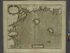
A chart of coast of BIAFRA from Foche Island to Corisco Island together with the Islands of FERNANDO POO and PRINCES
from The sea-atlas : containing an hydrographical description of most of the sea-coasts of the known parts of the world.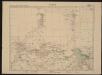
Carte de l'Afrique occidentale française. Zinder
1 : 2000000 France. Service géographique des colonies [Paris] : Service géographique des colonies
Dritter Deutscher Kolonialkongress 1910, Sektion IV, Karte 2

Carte des divisions administratives des territoires du sud
1 : 3200000 Calléja, N.; Gouvernement général de l'Algérie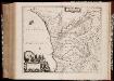
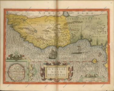
Regna Congo et Angola
1 : 3000000 Annotatie: Origineel is Blad 209 in atlas factice; Annotatie geografische gegevens: Schaalstok op kaart: 2 Milliaria Germanica Communia (=7,2 cm) [Amstelædami] : [Labore et Sumptibus Ioannis Blaev]
Algerien (Algerie)
1 : 2450000 Ziegler, J. M.
Afrika

[XXII], uit: Geognostische Karte des Oesterreichischen Kaiserstaates mit einem grossen Theile Deutschland's u. Italien / hauptsachlich nach ... Haidinger's geognostischer Karte dieses Staates bearb. von Josef Scheda
1 : 3000000 titelvariant: General-Karte von Europa in 25 Blättern; Annotatie: Bijlage bij: General-Karte von Europa in 25 Blättern. - 1:2.592.000. - 1845-1847 Scheda, Joseph Wien : K.K. Militär. Geografisch. Institut
Carte du Cameroun
1 : 2000000 Kamerun
Algérie et Tunisie
1 : 2000000 Niox, Gustave-Léon 1840-1921 Paris : Ch. Delagrave
Algerie, Tunisie.
1 : 2500000 Vivien St Martin, L.
Africa 1:2.000.000, Fezzan
Fezzan, Libya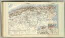
Algerie. Tunisie.
1 : 1970000 Jouvet et Cie.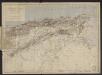
Algérie et Tunisie : d'après les documents fournis par le Dépôt de la guerre (Service géographique) : orthographe des noms arabes d'après les principes du Général Parmentier
1 : 1800000 Paris : Lith. Lemercier & Cie.