Maps of Crystal Mountains
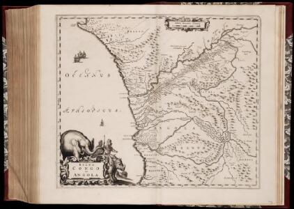
Regna Congo et Angola
1 : 3000000 Annotatie: Origineel is Blad 209 in atlas factice; Annotatie geografische gegevens: Schaalstok op kaart: 2 Milliaria Germanica Communia (=7,2 cm) [Amstelædami] : [Labore et Sumptibus Ioannis Blaev]
Colonie du Gabon. Afrique Equatoriale Française
1 : 1000000 Meunier, A., cartographe Paris : Ministère des colonies
Anzico. Afrique 38.
1 : 1641836 Vandermaelen, Philippe, 1795-1869
Carte de Angola: esboço / Ministerio das Colonias, Comissâo de Cartografia
1 Mapa. Ministerio das Colonias (Portugal). Comissâo de Cartografia
Provincia de Angola Porto do Ambriz à Baía dos Elefantes
1 : 750000 Hydrographic Map Instituto Hidrográfico Portugal Instituto Hidrográfico Portugal
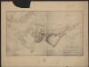
Karte des Handelsgebiets von West-Aequatoreal-Afrika
1 : 780000 L. Friedrichsen Hambourg : Friederichsen
Région des cours supérieurs de l'Ogôoué, de l'Alima et de la Licona (Carte provisoire)
1 : 1000000 Brazza, Pierre Savorgnan de 1852-1905 Paris : Société de géographie
Congo et Angola. Afrique 41.
1 : 1641836 Vandermaelen, Philippe, 1795-1869
Croquis hypsométrique du Congo occidental
1 : 1000000 Kongo (Kinshasa) Delhaye, F. Sluys, M. E. Patesson
Mapa de la Guinea Española / formado y publicado por el Depósito de la Guerra
1 : 500000 1 Mapa, col. Finestra: Plano del Rio Muni y sus afluentes Depósito de la Guerra (Espaya)
Mapa del Muni : Guinea continental española
1 mapa. Publicat dins: Anuario general de España. Datat a partir de 1900 aproximadament. Pompido, M. Publicado por `Anuarios Bailly-Baillère y Riera reunidos ́. Barcelona (ed. A)
The northern Bulu region according to the survey by First Lieutenant von Glisczinski, Lieutenant Nolte und Dr. Bennett in 1897 and 1898. Designed and drawn by Max Moisel. (Mittheilungen aus den deutschen Schutzgebieten)
Carte du bassin du Niari (Loudima-Comba)
1 : 250000 Lamy, François 1858-1900 Paris : Aron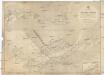
Afrika west coast
1 : 160000 Kongo (řeka) Vidal, R.N. Medlycott, Mervyn Bradford Admirality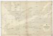
Afrika west coast
1 : 73000 Kongo (řeka) Medlycott, Mervyn Bradford Admirality
Provincia de Angola Porto de Luanda à Ponta das Palmeiras
1 : 60000 Hydrographic Map Instituto Hidrográfico Portugal Instituto Hidrográfico Portugal
De baij en stadt Loand de St. Paulo geleegen aen de kust van Angola in Guinea
Angola Gerard van Keulen
Provincia de Angola Baía de Benguela
1 : 20000 Hydrographic Map Instituto Hidrográfico Portugal Instituto Hidrográfico Portugal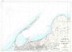
Provincia de Angola Porto de Luanda
1 : 15000 Hydrographic Map Instituto Hidrográfico Portugal Instituto Hidrográfico Portugal
Provincia de Angola Enseada do Quicombo
1 : 15000 Hydrographic Map Instituto Hidrográfico Portugal Instituto Hidrográfico Portugal
Provincia de Angola Porto do Lobito
1 : 10000 Hydrographic Map Instituto Hidrográfico Portugal Instituto Hidrográfico Portugal
Provincia de Angola Porto do Ambriz
1 : 10000 Hydrographic Map Instituto Hidrográfico Portugal Instituto Hidrográfico Portugal
Région du chemin de fer Congo-océan (esquisse topographique). Feuille 1 : Brazzaville-Kimbédi
1 : 250000 Lombard, Jean 1895-.... Paris : H. Barrère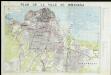
Plan de ville de Kinshasa

Karte der Insel Fernando Póo
1 : 200000 Baumann, Oscar Eduard Hölzel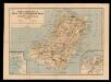
Nuevo mapa de la isla de Fernando Póo, vicariato Apostólico
1 Mapa, col. Finestra: Plano de Sta. Isabel Sucesores de Henricy y Ca.
Carte de Fernando Póo según Pellon / adicionada por los P.F. Misioneros Hijos del I.C. de María
1 Mapa. Pellón
[kein Titel]

Western half of Equatorial Africa and the expeditions on land and sea by Henry M. Stanley during 1874-77