Maps of Republic of Congo

Regna Congo et Angola. [Karte], in: Novus atlas absolutissimus, Bd. 6, S. 180.
1 Karte aus Atlas Janssonius Offizin
Nieder Guinea, W. Mittel-Africa.
1 : 5500000 Weiland, C. F. (Carl Ferdinand), d. 1847
Charte von Nieder Guinea
Angola
CHARTE von NIEDER GUINEA
Angola
Western half of Equatorial Africa and the expeditions on land and sea by Henry M. Stanley during 1874-77

Central Africa - western section.
1 : 5000000 John Bartholomew and Son
REGNA | CONGO | et | ANGOLA.
[Amsterdam : Joan Blaeu]
Kamerun
Dorsch, H.
Cameroon with Togo. Edited by Max Moisel

Spezial-Karte von Afrika
1 : 4000000 Blatt 7 Habenicht, Hermann Perthes
Kamerun mit Togo 1:2 000 000
1 : 2000000 Kamerun Moisel, Max Dietrich Reimer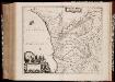
Regna Congo et Angola
1 : 3000000 Annotatie: Origineel is Blad 209 in atlas factice; Annotatie geografische gegevens: Schaalstok op kaart: 2 Milliaria Germanica Communia (=7,2 cm) [Amstelædami] : [Labore et Sumptibus Ioannis Blaev]
Afrique équatoriale Francaise
1 : 5000000 Afrika střední Barralier, Emmanuel Emile Larose
Schutzgebiete Kamerun und Togo [in vier Blättern] Blatt 1

Missions Protestantes au Cameroun.

Dritter Deutscher Kolonialkongress 1910, Sektion IV, Karte 2

Carta do Sul de Angola compreendendo a regiao situada ao sul do paralello 14\00BA
1 : 500000 Angola Ministerio das Colonias, Comissao de Cartografia
West Africa.
1 : 2500000 Andree, Richard; Times (London, England)
Afrique equatoriale Française
1 : 2000000 Kongo (Brazzaville) Meunier, A. Courtier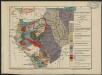
Carte géologique de l'Afrique équatoriale française. Planche sud
1 : 5000000 Loir, Erasme, géologue 18..-19.. Paris : Larose
Carte de Angola: esboço / Ministerio das Colonias, Comissâo de Cartografia
1 Mapa. Ministerio das Colonias (Portugal). Comissâo de Cartografia
Carte du Cameroun
1 : 2000000 Kamerun
Localisatin of ethnic groups. Southern section. Sheet XI

Anzico. Afrique 38.
1 : 1641836 Vandermaelen, Philippe, 1795-1869
Congo et Angola. Afrique 41.
1 : 1641836 Vandermaelen, Philippe, 1795-1869
Benguela. Afrique 44.
1 : 1641836 Vandermaelen, Philippe, 1795-1869
Vorläufige übersicht von Zintgraff's Reise von Kamerun nach dem Benuë
1 : 3500000 Kamerun C.L. Keller
Colonie du Gabon. Afrique Equatoriale Française
1 : 1000000 Meunier, A., cartographe Paris : Ministère des colonies
Pays, sud de Howssa et de Bornou. Afrique 29.
1 : 1641836 Vandermaelen, Philippe, 1795-1869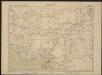
![Regna Congo et Angola. [Karte], in: Novus atlas absolutissimus, Bd. 6, S. 180.](https://images-2.georeferencer.com/images/iiif/888104944915/full/,300/0/native.jpg)

