Maps of Kiev

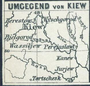
Umgegend von Kiew
Kiew, Umland
Li palatinati di Braclaw, e Kiowia / tratta dall'atlante polacco del Sig.r Rizzi Zanoni ; G. Zuliani
1 : 740000 1 Karte : Kupferdruck ; 40 x 31 cm Zuliani, Giuliano presso Antonio Zatta
TRACTVS | BORYSTHENIS | Vulgo DNIEPR et NIEPR dicti, | à KIOVIA usque ad BOUZIN.
Amstelædami | Excud. I. BLAEV.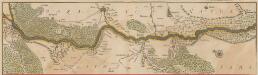
Tractus Borysthenis Vulgo Dniepr et Niepr dicti, à Kiovia ad Urbum Oczakow ubi in pontum Euxinum se exonerat. [Karte, Teil 1], in: Novus atlas absolutissimus, Bd. 1, S. 73.
1 Karte aus Atlas Janssonius Offizin
Kiew & Höhlenkloster
1 : 200000 Kiew, Pecers'ka Lavra (Kiew)
Kiew
1 : 50000 Kiew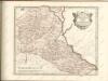

Übersichtskarte von Mittel - Europa
Basse Volhynie, ou palatinat de Kiow / tiré entierement de la gra[n]de Ukraine, du Sieur le Vasseur
1 : 875000 1 Karte : Kupferdruck ; 41 x 56 cm Sanson, Nicolas chez P. Mariette
Li Palatinati di Braclaw

[Střední Ukrajina]
Ukrajina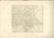
Rvssiæ, vulgo Moscovia, pars australis / auctore Isaaco Massa
1 : 3910000 1 Karte : Kupferdruck ; 38 x 51 cm Massa, Isaac Abrahamsz Apud Johan et Cornelium Blaeu
Partie, Russie d'Europe. Europe 15.
1 : 1641836 Vandermaelen, Philippe, 1795-1869
Russia in Europe Part V.
1 : 2100000 Society for the Diffusion of Useful Knowledge (Great Britain)
Gouv. 29. Jekatarinoslaw
1 : 2300000 1 Karte : Lithographie ; 19 x 26 cm Schlieben, W.E.A. von [Georg Joachim Göschen]
Von dem Landt Armenia dem groessern
1 : 3800000 1 Karte : Holzschnitt ; 24 x 16 cm Münster, Sebastian [Henricpetri]
Sarmatia Asie
1 : 3800000 1 Karte : Holzschnitt ; 24 x 16 cm Münster, Sebastian [Henricpetri]
Sarmatia Asie
1 : 3800000 1 Karte : Holzschnitt ; 24 x 16 cm Münster, Sebastian [Henricpetri]
Sarmatia Asie
1 : 3800000 1 Karte : Holzschnitt ; 24 x 16 cm Münster, Sebastian [Henricpetri]
Russia 5.
1 : 2217600 Letts, Son & Co.
[Sarmatia]
1 : 6630000 1 Karte : Holzschnitt ; 8 x 14 cm Münster, Sebastian [Henricpetri]
Gouv. 9. Twer, 14. Jaroslaw
1 : 2200000 1 Karte : Lithographie ; 19 x 26 cm Schlieben, W.E.A. von [Georg Joachim Göschen]
Gouv. 24. Woronesh, 28. Slobodsk Ukraïne
1 : 2200000 1 Karte : Lithographie ; 20 x 26 cm Schlieben, W.E.A. von [Georg Joachim Göschen]
I governi di Moscovia, di Niz-Novogorod e di Kazan
1 : 4900000 1 Karte : Kupferdruck ; 22 x 31 cm Presso Pazzini Carli
Generalʹnaja karta Kavkazskago kraja / izdana pri Voennom sbornikė
1 : 1300000 1 Karte gefaltet : Lithografie ; 75 x 91 cm [Verlag nicht ermittelbar]
Gouv. 16. Wladimir, 20. Tula
1 : 2300000 1 Karte : Lithographie ; 26 x 19 cm Schlieben, W.E.A. von [Georg Joachim Göschen]

Internationale Weltkarte. M - 36 Kijev