Maps of Moldova


Karta Raīona Largo-Kagul'skoj operacīi v 1770 g.
Moldawien Kagul Krieg
Karta teatra vojn 1769-1774 gg. i 1787-1791 gg.
Rumänien Moldawien Krieg Suvorov, Aleksandr V.
I governi di Moscovia, di Niz-Novogorod e di Kazan
1 : 4900000 1 Karte : Kupferdruck ; 22 x 31 cm Presso Pazzini Carli
Gouv. 24. Woronesh, 28. Slobodsk Ukraïne
1 : 2200000 1 Karte : Lithographie ; 20 x 26 cm Schlieben, W.E.A. von [Georg Joachim Göschen]
Russia in Europe Part VIII with index map.
1 : 2250000 Society for the Diffusion of Useful Knowledge (Great Britain)
Generalʹnaja karta Kavkazskago kraja / izdana pri Voennom sbornikė
1 : 1300000 1 Karte gefaltet : Lithografie ; 75 x 91 cm [Verlag nicht ermittelbar]
Tabula Geographica
1 : 1600000 Mollova mapová sbírka Homann, Johann Baptist Homann, Johann Baptista - dědici
Gouv. 9. Twer, 14. Jaroslaw
1 : 2200000 1 Karte : Lithographie ; 19 x 26 cm Schlieben, W.E.A. von [Georg Joachim Göschen]
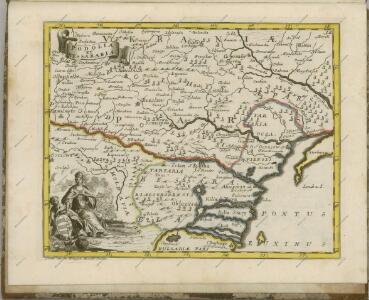
Tabula geographica continens despotatus Wallachiae atque Moldaviae, provinciam Bessarabiae sub clientela Turcica, itemque provinciam polonicam Podoliae
1 : 1500000 Besarábie (Moldavsko a Ukrajina) ab Homannianis Heredibus
Karte von Bessarabien, Podolien und den angrenzenden Ländern
1 : 900000 entworfen und gezeichnet von F. Handtke Glogau : C. Flemming
Die Gegend zwischen Pultava und Bender Mitt Angraenzenden Polnisch, Türkisch und Tartarischen Lands
1 : 2000000 1 Karte : Kupferdruck ; 16 x 29 cm Bodenehr, Gabriel [Verlag nicht ermittelbar]
Gouv. 29. Jekatarinoslaw
1 : 2300000 1 Karte : Lithographie ; 19 x 26 cm Schlieben, W.E.A. von [Georg Joachim Göschen]
Podolia et Bessarabia.
1 : 2200000 Mollova mapová sbírka Bruggen, Johann van der Brugge, Johannes van der
Moldavia
1 : 2200000 Mollova mapová sbírka Pfeffel, Johann Andreas
Rvssiæ, vulgo Moscovia, pars australis / auctore Isaaco Massa
1 : 3910000 1 Karte : Kupferdruck ; 38 x 51 cm Massa, Isaac Abrahamsz Apud Johan et Cornelium Blaeu
Sarmatia Asie
1 : 3800000 1 Karte : Holzschnitt ; 24 x 16 cm Münster, Sebastian [Henricpetri]
Sarmatia Asie
1 : 3800000 1 Karte : Holzschnitt ; 24 x 16 cm Münster, Sebastian [Henricpetri]
Sarmatia Asie
1 : 3800000 1 Karte : Holzschnitt ; 24 x 16 cm Münster, Sebastian [Henricpetri]
Von dem Landt Armenia dem groessern
1 : 3800000 1 Karte : Holzschnitt ; 24 x 16 cm Münster, Sebastian [Henricpetri]
Die Gegend zwischen Pultava und Bender mit angraenzenden Polnisch, Türkisch und Tartarischen Landschaften
1 : 2640000 Poltava (Ukrajina) Bodenehr, Gabriel Gabriel Bodenehr
Tabula geographica continens despotatus Wallachiae atque Moldaviae, provinciam Bessarabiae sub clientela Turcica, itemque provinciam polonicam Podoliae
1 : 1500000 Besarábie (Moldavsko a Ukrajina) Homannianis Heredibus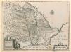
Principatus Moldaviae descriptio
Principatus Moldaviae descriptio, delineante Principe Demetrio Cantemirio. Changuion
Moldau um 1930. Stadtbevölkerung
Moldawien ethnische Gruppe, Stadtbevölkerung Hofinger, Veronika
Charte von Bessarabien
1 : 1637000 Besarábie (Moldavsko a Ukrajina) Schlieben Gleditsch
Moldau um 1930. Zigeuner
Moldawien ethnische Gruppe, Roma
Moldau um 1930. Deutsche
Moldawien ethnische Gruppe, Deutsche Hofinger, Veronika
Moldau um 1930. Volksgruppen (Bevölkerung außerhalb der Städte)
Moldawien ethnische Gruppe, Landbevölkerung Hofinger, Veronika
Moldau um 1930. Rumänen
Moldawien ethnische Gruppe, Rumänen Hofinger, Veronika