Maps of Kiev

[Střední Ukrajina]
Ukrajina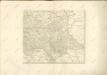

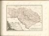
Li Palatinati di Braclaw
Basse Volhynie, ou palatinat de Kiow / tiré entierement de la gra[n]de Ukraine, du Sieur le Vasseur
1 : 875000 1 Karte : Kupferdruck ; 41 x 56 cm Sanson, Nicolas chez P. Mariette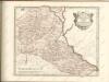

Théatre de la guerre actuelle, en Allemagne, en Pologne et en Turquie. n5, Brody
1 : 900000 Chanlaire, Pierre Grégoire 1758-1817 Paris : chez l'auteur P. G. Chanlaire
Übersichtskarte von Mittel - Europa
Karta putej dviženīja armīi Minicha v 1739 g.
Ukraine Černivci Krieg Minich, Burchard-Christofor
Bez titulu: Šest listů speciálních map Ukrajiny

Internationale Weltkarte. M - 36 Kijev

Europe 1:1,000,000, Kiev
Sheet including Ukraine from the map series: Europe. Scale, 1 :1,000,000. [Including Asia Minor, Mesopotamia, etc.] Provisional edition. Compiled at the Royal Geographical Society ... drawn and printed by the Ordnance Survey G.S.G.S. No. 2758. London : Geographical Section, General Staff.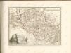

Li palatinati di Braclaw, e Kiowia / tratta dall'atlante polacco del Sig.r Rizzi Zanoni ; G. Zuliani
1 : 740000 1 Karte : Kupferdruck ; 40 x 31 cm Zuliani, Giuliano presso Antonio Zatta
Bałta, Umań, Bracław
1 : 750000 Braslaw (Bělorusko : oblast) Mach, O. K. u. k. Militärgeographisches Institut
Balta, Uman, Braclaw
1 : 750000 Braslaw (Bělorusko : oblast) K. k. militär-geographisches Institut
Übersichtskarte von Mittel - Europa

Umgegend von Kiew
Kiew, Umland
Ukrainae pars, quae Podolia palatinatus vulgo dicitur / per Guil. le Vasseur de Beauplan s. r. m.tis
1 : 420000 1 Karte : Kupferdruck ; 43 x 52 cm Beauplan, Guillaume le Vasseur de [Verlag nicht ermittelbar]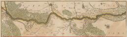
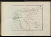
Tractus Borysthenis Vulgo Dniepr et Niepr dicti, à Kiovia ad Urbum Oczakow ubi in pontum Euxinum se exonerat. [Karte, Teil 1], in: Novus atlas absolutissimus, Bd. 1, S. 73.
1 Karte aus Atlas Janssonius Offizin
Neue Generalkarte des Österr.-ungar.-russischen Kriegsschauplatzes

Carte de la Roumanie et pays limitrophes. Balta
1 : 500000 France. Service géographique de l'armée [Paris] : Service géographique de l'armée
TRACTVS | BORYSTHENIS | Vulgo DNIEPR et NIEPR dicti, | à KIOVIA usque ad BOUZIN.
Amstelædami | Excud. I. BLAEV.
Generalkarte von Zentraleuropa

Generalkarte von Zentraleuropa

Generalkarte von Zentraleuropa

Generalkarte von Zentraleuropa

Neue Generalkarte des Österr.-ungar.-russischen Kriegsschauplatzes

Brest-Litowsk, Pinsk, Ostrog, Kołki
1 : 750000 Brest (Bělorusko : oblast) Geng, K. K. u. k. Militärgeographisches Institut
![[Střední Ukrajina]](https://images-2.georeferencer.com/images/iiif/073631528816/full/,300/0/native.jpg)

