Maps of Zhytomyr Oblast

Übersichtskarte von Mittel - Europa

Li palatinati di Braclaw, e Kiowia / tratta dall'atlante polacco del Sig.r Rizzi Zanoni ; G. Zuliani
1 : 740000 1 Karte : Kupferdruck ; 40 x 31 cm Zuliani, Giuliano presso Antonio Zatta
Umgegend von Kiew
Kiew, Umland
TRACTVS | BORYSTHENIS | Vulgo DNIEPR et NIEPR dicti, | à KIOVIA usque ad BOUZIN.
Amstelædami | Excud. I. BLAEV.
Speciální mapa západního Ruska
Österreich-Ungarns letzter Krieg
1 : 750000 Dunaj-delta (Rumunsko a Ukrajina) Verlag der Militärwissenschaftlichen Mitteilungen
Kiew & Höhlenkloster
1 : 200000 Kiew, Pecers'ka Lavra (Kiew)
Kiew
1 : 50000 Kiew
Speciální mapa západního Ruska

Speciální mapa západního Ruska
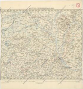
g. Volynskoj (Rjad XXII., list 6)

Théatre de la guerre actuelle, en Allemagne, en Pologne et en Turquie. n5, Brody
1 : 900000 Chanlaire, Pierre Grégoire 1758-1817 Paris : chez l'auteur P. G. Chanlaire
Li Palatinati di Braclaw

[Střední Ukrajina]
Ukrajina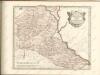
Basse Volhynie, ou palatinat de Kiow / tiré entierement de la gra[n]de Ukraine, du Sieur le Vasseur
1 : 875000 1 Karte : Kupferdruck ; 41 x 56 cm Sanson, Nicolas chez P. Mariette
Gipsometričeskaja karta Polěs'ja s oboznačenijem kanalizacii
1 : 1250000 Polesí
Karta Černigovskoj gubernii
1 : 840000 Černigov-oblast (Ukrajina) Kartogr. zav. A. Il'jina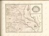
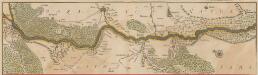
Tractus Borysthenis Vulgo Dniepr et Niepr dicti, à Kiovia ad Urbum Oczakow ubi in pontum Euxinum se exonerat. [Karte, Teil 1], in: Novus atlas absolutissimus, Bd. 1, S. 73.
1 Karte aus Atlas Janssonius Offizin
Bez titulu: Šest listů speciálních map Ukrajiny

Partie, Russie d'Europe. Europe 15.
1 : 1641836 Vandermaelen, Philippe, 1795-1869
Russia in Europe Part V.
1 : 2100000 Society for the Diffusion of Useful Knowledge (Great Britain)
Russia 5.
1 : 2217600 Letts, Son & Co.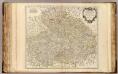
Boheme, Silesie, Moravie et Lusace.
1 : 900000 Robert de Vaugondy, Gilles, 1688-1766
Trigonometrisk grunnlag, vedlegg 65, 1c: Grunnlagspunkter for Struves meridianbue fra Hrodna til Odessa
1 : 1440000
[Sarmatia]
1 : 6630000 1 Karte : Holzschnitt ; 8 x 14 cm Münster, Sebastian [Henricpetri]
Typus Generalis Ukrainae sive Palatinatuum Podoliae, Kioviensis et Braczlaviensis terras nova delineatione ex hibens. [Karte], in: Novus atlas absolutissimus, Bd. 1, S. 104.
1 Karte aus Atlas Janssonius Offizin