Maps of Alor

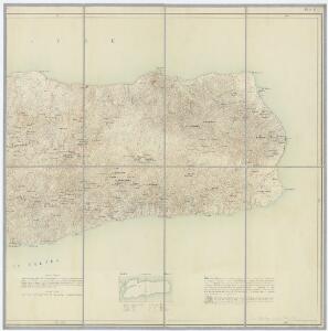
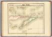
Blad II, uit: Overzichtskaart van het Eiland Alor / vluchtig opgenomen door den Topografischen Dienst in 1927-1928
1 : 100000 Annotatie: Met bladindeling en toelichtingen; Gegevens verzameld over de periode/Data collected over the period: 1927-1928; Op de kaart wordt de nul meridiaan van Batavia aangegeven; Annotatie geografische gegevens: Legenda Topografische Dienst, Batavia; Topografische Dienst, Nederlandsch-Indië Batavia : Reproductiebedrijf Topografische Dienst
Dilly / Survey of India
Survey of India [S.l.] : Survey of India
Carta da Provincia da Timor
1 : 1000000 Wall Map M. Diniz Institut Cartographique de Paris
Schetskaart van Nederlandsch Timor en omliggende eilanden / Topographische Inrichting
Topografische Inrichting Batavia Batavia : Topographische Inrichting
Ilha de Timor / desenhada Antonio Aug. de Santos Victal
Dilly : [s.n.]
Carta da provincia de Timor
1 : 1000000 Timor (Indonésie) Ministerio das colonias
Kaart van het Eiland Timor / zamengesteld door G.H. Heymering ; lith[ographie] door C. Franz
Batavia : Lith[ographie] der Genie
Ilha de Timor / desenhada por Antonio Aug. de Santos Victal
[S.l. : Repartiçao das Obras Publicas Timor]
Ilha de Timor / desenhada por Antonio Aug. de Santos Victal
Dilly : [s.n.]
Essai sur la géographie de l'Île Timor
Havajské ostrovy Freycinet, L. de
Koepang / U.S. Army Map Service
U.S. Army Map Service Washington D.C. Washington D.C. : U.S. Army Map Service
Koepang / Topografische Dienst
Topografische Dienst Batavia Batavia : Reproductiebedrijf Topografische Dienst
Koepang / Topografische Dienst
Topografische Dienst Batavia Batavia : Reproductiebedrijf Topografische Dienst
Flores, Soemba, Timor
Ile Timor. Oceanique no. 28.
1 : 1641836 Vandermaelen, Philippe, 1795-1869
Kaart der zuyd-wester eylanden van Banda
1 : 1700000 [Dordrecht etc.] : J. van Braam et G. o. Linden exc.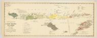
Schets-taalkaart van de Kleine Soenda Eilanden / vervaardigd door K.F. Holle, Adviseur Honorair, voor Inlandsche Zaken, naar gegevens van de Ambtenaren van Binnenlandsch Bestuur en met medewerking van het Topographisch Bureau te Batavia
1 : 1500000 Annotatie: Behoort bij het Koloniaal Verslag van 1893; Annotatie geografische gegevens: Legenda Batavia : Topographisch Bureau
Kleine Soenda Eilanden : aangevende het aantal inrichtingen voor Inlandsch Onderwijs op 31 december 1914 / Top[ographische] Inr[ichting]
Topographische Inrichting Batavia Batavia : Top[ographische] Inr[ichting]
Kaart van de Molukken
D. Heyse, graveur lith. te 's Hage te 's Hage : uitgave van K. Fuhri
Algemeene schetskaart van Nederlandsch-Indië : Gouv[ernement] Groote Oost, Res[identie] Manado / Topografische Dienst, Batavia
[S.l. : s.n.]
Celebes, de Kleine Soenda-Eilanden / Geogr[aphische] lithogr[aphie] v[an] E. de Geest
Seyffardt's Boekhandel Amsterdam Amsterdam : Lith[ographische] Drukkerij van Seyffardt's Boekhandel te Amsterdam
Geologische schetskaart van het oostelijke gedeelte van den Nederlandsch-Indischen Archipel / door Dr. R.D.M. Verbeek
Topographische Inrichting Batavia [Batavia : Landsdrukkerij]
Carte des iles Moluques
1 : 3425000 par P. Melvill de Carnbee gravé par D. Heyse La Haye : lith de Ch. van Lier
Kaart van het oostelijke gedeelte van den Nederlandsch-Indischen Archipel / Topographische Inrichting
Topographische Inrichting Batavia [Batavia : Landsdrukkerij]
Insula Borneo in Indonesia : Præfectura Apostolica Bornæi Hollandici : anno 1905 erecta eiusque regiones vicinæ et dismembrationes ecclesiasticæ
1 : 16500000 titelvariant: Præfectura Apostolica Bornæi Hollandici [S.l. : Vicario Apostolico de Pontianak]
Kaart van Nederlandsch Oost-Indië op een schaal van 1:1.800.000 / naar de nieuwste bronnen bew. onder toezicht van I. Dornseiffen door E. de Geest
1 : 1800000 Annotatie geografische gegevens: Inzet: De Natoena-eilanden; Noordelijk gedeelte der Tidoengsche landen; De Taloer- of Salibao-Eilanden; Atjih, Babi en Nias; Nieuw-Guinea (Nederlandsch gedeelte) en nabijliggende eilanden. - 1:6.000.000 Isaac Dornseiffen 1818-1898; Evert de Geest 1838-? Amsterdam : Seyffardt
Blad VII Siding, uit: Residentie Wester-Afdeeling van Borneo / Topographisch Bureau
1 : 200000 titelvariant: Residentie Westerafdeeling van Borneo; Annotatie: Titelvariant: Residentie Westerafdeeling van Borneo; Voor aanwezige bladen zie overzichtsblad; Annotatie geografische gegevens: Opname: 1886-1895 Topographisch Bureau, Batavia Batavia : Topographisch Bureau
Indonesia
IPPRESS Djakarta [Djakarta] : IPPRESS
La presqu'isle de l'Indie au dela du Gange, avec l'archipel des Indes
1 : 12640000 Asie jihovýchodní Bonne, Rigobert André