Maps of Lesser Sunda Islands

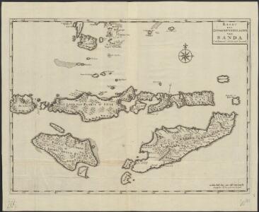
Kaart der zuyd-wester eylanden van Banda
1 : 1700000 [Dordrecht etc.] : J. van Braam et G. o. Linden exc.
Kleine Soenda Eilanden : aangevende het aantal inrichtingen voor Inlandsch Onderwijs op 31 december 1914 / Top[ographische] Inr[ichting]
Topographische Inrichting Batavia Batavia : Top[ographische] Inr[ichting]
Ile Timor. Oceanique no. 28.
1 : 1641836 Vandermaelen, Philippe, 1795-1869
Schets-taalkaart van de Kleine Soenda Eilanden / vervaardigd door K.F. Holle, Adviseur Honorair, voor Inlandsche Zaken, naar gegevens van de Ambtenaren van Binnenlandsch Bestuur en met medewerking van het Topographisch Bureau te Batavia
1 : 1500000 Annotatie: Behoort bij het Koloniaal Verslag van 1893; Annotatie geografische gegevens: Legenda Batavia : Topographisch Bureau
Flores, Soemba, Timor
Essai sur la géographie de l'Île Timor
Havajské ostrovy Freycinet, L. de
Ilha de Timor / desenhada por Antonio Aug. de Santos Victal
Dilly : [s.n.]
Koepang / U.S. Army Map Service
U.S. Army Map Service Washington D.C. Washington D.C. : U.S. Army Map Service
Koepang / Topografische Dienst
Topografische Dienst Batavia Batavia : Reproductiebedrijf Topografische Dienst
Koepang / Topografische Dienst
Topografische Dienst Batavia Batavia : Reproductiebedrijf Topografische Dienst
Ilha de Timor / desenhada por Antonio Aug. de Santos Victal
[S.l. : Repartiçao das Obras Publicas Timor]
Kaart van het Eiland Timor / zamengesteld door G.H. Heymering ; lith[ographie] door C. Franz
Batavia : Lith[ographie] der Genie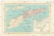
Carta da provincia de Timor
1 : 1000000 Timor (Indonésie) Ministerio das colonias
Ilha de Timor / desenhada Antonio Aug. de Santos Victal
Dilly : [s.n.]
Schetskaart van Nederlandsch Timor en omliggende eilanden / Topographische Inrichting
Topografische Inrichting Batavia Batavia : Topographische Inrichting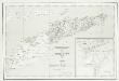
Carta da Provincia da Timor
1 : 1000000 Wall Map M. Diniz Institut Cartographique de Paris
Dilly / Survey of India
Survey of India [S.l.] : Survey of India
Ilitalo / Survey of India
Survey of India [S.l.] : Survey of India
Benteng / Survey of India
Survey of India [S.l.] : Survey of India
Kaart van het eiland Flores / door A. Wichmann
Koninklijk Nederlandsch Aardrijkskundig Genootschap Amsterdam Leiden : E.J. Brill
Res. Timor en Onderh., Blad 88/XLIX-L [243-244], uit: Res. Timor en onderh
1 : 100000 Annotatie: Aanwezig: 3 bladen West-Timor en 4 bladen Roti; Annotatie geografische gegevens: Geografische plaatsbepaling t.o.v. de 0-meridiaan van Batavia; Op elk blad een kaartje met de administratieve indeling tot het niveau van landschappen Batavia : Topografische dienst
Heteiland Flores / J.G. veth, del. 1874
Aardrijkskundig Genootschap Amsterdam Amsterdam : C.F. Stemler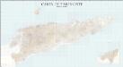
Carta de Timor-Leste
1 : 50000 Topographic Map Centro de Geografia do Ultramar Serviço Cartográfico do Exército
Kaart van een gedeelte van het eiland Timor met de grenzen op dat eiland van het Nederlandsch en Portugeesch gebied volgens het tractaat van 1 october 1904
Koninklijk Nederlandsch Aardrijkskundig Genootschap Amsterdam Leiden : Boekhandel en Drukkerij voorheen E.J. Brill
Kaart van het Eiland Soemba / Topographisch Bureau, januari 1897 ; [Met aantekening in pen: herziene herdruk juli 1897 door H.D.H. Bosboom]
Topographisch Bureau Batavia Batavia : Topographisch Bureau
Schetskaart van het eiland Soemba / Topographische Inrichting
Topographische Inrichting Batavia Batavia : Topographische Inrichting
Portuguese Timor = Portugeesch Timor / Topografische Dienst
Topografische Dienst Batavia Batavia : Reproductiebedrijf Topografische Dienst
Raba / Survey of India
Survey of India [S.l.] : Survey of India
Postiljon Eilanden / Survey of India
Survey of India [S.l.] : Survey of India