Maps of East Nusa Tenggara
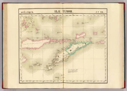
Ile Timor. Oceanique no. 28.
1 : 1641836 Vandermaelen, Philippe, 1795-1869
Kaart der zuyd-wester eylanden van Banda
1 : 1700000 [Dordrecht etc.] : J. van Braam et G. o. Linden exc.
Koepang / U.S. Army Map Service
U.S. Army Map Service Washington D.C. Washington D.C. : U.S. Army Map Service
Koepang / Topografische Dienst
Topografische Dienst Batavia Batavia : Reproductiebedrijf Topografische Dienst
Koepang / Topografische Dienst
Topografische Dienst Batavia Batavia : Reproductiebedrijf Topografische Dienst
Essai sur la géographie de l'Île Timor
Havajské ostrovy Freycinet, L. de
Ilha de Timor / desenhada por Antonio Aug. de Santos Victal
Dilly : [s.n.]
Flores, Soemba, Timor

Ilha de Timor / desenhada por Antonio Aug. de Santos Victal
[S.l. : Repartiçao das Obras Publicas Timor]
Kaart van het Eiland Timor / zamengesteld door G.H. Heymering ; lith[ographie] door C. Franz
Batavia : Lith[ographie] der Genie
Carta da provincia de Timor
1 : 1000000 Timor (Indonésie) Ministerio das colonias
Ilha de Timor / desenhada Antonio Aug. de Santos Victal
Dilly : [s.n.]
Schetskaart van Nederlandsch Timor en omliggende eilanden / Topographische Inrichting
Topografische Inrichting Batavia Batavia : Topographische Inrichting
Carta da Provincia da Timor
1 : 1000000 Wall Map M. Diniz Institut Cartographique de Paris
Dilly / Survey of India
Survey of India [S.l.] : Survey of India
Carta de Timor-Leste
1 : 50000 Topographic Map Centro de Geografia do Ultramar Serviço Cartográfico do Exército
Ilitalo / Survey of India
Survey of India [S.l.] : Survey of India
Kaart van een gedeelte van het eiland Timor met de grenzen op dat eiland van het Nederlandsch en Portugeesch gebied volgens het tractaat van 1 october 1904
Koninklijk Nederlandsch Aardrijkskundig Genootschap Amsterdam Leiden : Boekhandel en Drukkerij voorheen E.J. Brill
Portuguese Timor = Portugeesch Timor / Topografische Dienst
Topografische Dienst Batavia Batavia : Reproductiebedrijf Topografische Dienst
Benteng / Survey of India
Survey of India [S.l.] : Survey of India
Kaart van het eiland Flores / door A. Wichmann
Koninklijk Nederlandsch Aardrijkskundig Genootschap Amsterdam Leiden : E.J. Brill
Heteiland Flores / J.G. veth, del. 1874
Aardrijkskundig Genootschap Amsterdam Amsterdam : C.F. Stemler
Schetskaart van Timor (Nederlandsch gebied) / Topographische Inrichting Batavia 1920 ; bijgewerkt t[ot en] m[et] februari 1919
Topographische Inrichting Batavia Batavia : Topographische Inrichting
Overzichtskaart van Timor : Nederlandsch gebied = General map of Timor (Netherlands territory) / Topografische Dienst
Topografische Dienst Batavia Batavia : Reproductiebedrijf Topografische Dienst
[Met aantekeningen], uit: Schetskaart van Timor (Nederlandsch gebied) / [door de] Topographische Inrichting, Batavia
1 : 250000 Annotatie: Gegevens verzameld over de periode/Data collected over the period: 1919; Op de kaart wordt de administratieve indeling t/m landschappen aangegeven; Bijgewerkt t/m Februari 1919; Met opgave van de bestuurlijke indeling; Annotatie geografische gegevens: Schaalstok van 25 K.M. (=10 cm); Legenda Topografische Inrichting, Batavia; Topografische inrichting in Nederlandsch-Indië/1Batavia Batavia : Topographische Inrichting
[Zonder aantekeningen], uit: Schetskaart van Timor (Nederlandsch gebied) / [door de] Topographische Inrichting, Batavia
1 : 250000 Annotatie: Gegevens verzameld over de periode/Data collected over the period: 1919; Op de kaart wordt de administratieve indeling t/m landschappen aangegeven; Bijgewerkt t/m Februari 1919; Met opgave van de bestuurlijke indeling; Annotatie geografische gegevens: Schaalstok van 25 K.M. (=10 cm); Legenda Topografische Inrichting, Batavia; Topografische inrichting in Nederlandsch-Indië/1Batavia Batavia : Topographische Inrichting
[Timor : kaart naar Gago Coutinho met gebruikmaking van diens opname]
[S.l. : s.n.]
Schetskaart van het Landschap Beloe / P.J. Spruijt

Timor : carta topographica da regiao central a lesta da fronteira Luso - Hollandeza / pelo 1ÿê tenente da armada Gago Coutinho ; coordenada pelo tenente d'infanteria M. Luna
Bat[avia] : Top[ographische] Inr[ichting]