Maps of East Nusa Tenggara

Flores, Soemba, Timor

Koepang / U.S. Army Map Service
U.S. Army Map Service Washington D.C. Washington D.C. : U.S. Army Map Service
Koepang / Topografische Dienst
Topografische Dienst Batavia Batavia : Reproductiebedrijf Topografische Dienst
Koepang / Topografische Dienst
Topografische Dienst Batavia Batavia : Reproductiebedrijf Topografische Dienst
Schetskaart van Nederlandsch Timor en omliggende eilanden / Topographische Inrichting
Topografische Inrichting Batavia Batavia : Topographische Inrichting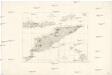
Essai sur la géographie de l'Île Timor
Havajské ostrovy Freycinet, L. de
Dilly / Survey of India
Survey of India [S.l.] : Survey of India
Kaart van het Eiland Timor / zamengesteld door G.H. Heymering ; lith[ographie] door C. Franz
Batavia : Lith[ographie] der Genie
Ilha de Timor / desenhada por Antonio Aug. de Santos Victal
Dilly : [s.n.]
Ilha de Timor / desenhada por Antonio Aug. de Santos Victal
[S.l. : Repartiçao das Obras Publicas Timor]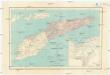
Carta da provincia de Timor
1 : 1000000 Timor (Indonésie) Ministerio das colonias
Ilha de Timor / desenhada Antonio Aug. de Santos Victal
Dilly : [s.n.]
Kaart van het eiland Flores / door A. Wichmann
Koninklijk Nederlandsch Aardrijkskundig Genootschap Amsterdam Leiden : E.J. Brill
Heteiland Flores / J.G. veth, del. 1874
Aardrijkskundig Genootschap Amsterdam Amsterdam : C.F. Stemler
Kaart van een gedeelte van het eiland Timor met de grenzen op dat eiland van het Nederlandsch en Portugeesch gebied volgens het tractaat van 1 october 1904
Koninklijk Nederlandsch Aardrijkskundig Genootschap Amsterdam Leiden : Boekhandel en Drukkerij voorheen E.J. Brill
Schetskaart van het eiland Soemba / Topographische Inrichting
Topographische Inrichting Batavia Batavia : Topographische Inrichting
Schetskaart van het Eiland Soemba / Topographische Inrichting
Topographische Inrichting Batavia Batavia : Topographische Inrichting
Kaart van het Eiland Soemba / Topographisch Bureau, januari 1897 ; [Met aantekening in pen: herziene herdruk juli 1897 door H.D.H. Bosboom]
Topographisch Bureau Batavia Batavia : Topographisch Bureau
Schetskaart van Timor (Nederlandsch gebied) / Topographische Inrichting Batavia 1920 ; bijgewerkt t[ot en] m[et] februari 1919
Topographische Inrichting Batavia Batavia : Topographische Inrichting
Overzichtskaart van Timor : Nederlandsch gebied = General map of Timor (Netherlands territory) / Topografische Dienst
Topografische Dienst Batavia Batavia : Reproductiebedrijf Topografische Dienst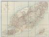
[Met aantekeningen], uit: Schetskaart van Timor (Nederlandsch gebied) / [door de] Topographische Inrichting, Batavia
1 : 250000 Annotatie: Gegevens verzameld over de periode/Data collected over the period: 1919; Op de kaart wordt de administratieve indeling t/m landschappen aangegeven; Bijgewerkt t/m Februari 1919; Met opgave van de bestuurlijke indeling; Annotatie geografische gegevens: Schaalstok van 25 K.M. (=10 cm); Legenda Topografische Inrichting, Batavia; Topografische inrichting in Nederlandsch-Indië/1Batavia Batavia : Topographische Inrichting
Schetskaart van het eiland Soemba / Top[ographische] Inr[ichting]
Topografische Inrichting Batavia Bat[avia] : Top[ographische] Inr[ichting]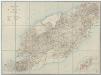
[Zonder aantekeningen], uit: Schetskaart van Timor (Nederlandsch gebied) / [door de] Topographische Inrichting, Batavia
1 : 250000 Annotatie: Gegevens verzameld over de periode/Data collected over the period: 1919; Op de kaart wordt de administratieve indeling t/m landschappen aangegeven; Bijgewerkt t/m Februari 1919; Met opgave van de bestuurlijke indeling; Annotatie geografische gegevens: Schaalstok van 25 K.M. (=10 cm); Legenda Topografische Inrichting, Batavia; Topografische inrichting in Nederlandsch-Indië/1Batavia Batavia : Topographische Inrichting
Overzichtskaart van de Afdeeling Soemba : (behoort tot de Res[identie] Timor en Onderh[oorigheden] / Topografische Dienst
Topografische Dienst Weltevreden (Batavia) Weltevreden (Batavia) : Reproductiebedrijf Topografische Dienst
Waikaboebak ; Waingapoe / prepared under the direction of the Chief Engineers, U.S. Army by the Army Map Service, 1943 ; reproduced by 110 Map Production Co[mpan]y R.E. ; Survey Production Centre South East Asia, 1945
US Army Map Service Washington D.C. Washington D.C. : U.S. Army Map Service
Res. Timor en Onderh., Blad 88/XLIX-L [243-244], uit: Res. Timor en onderh
1 : 100000 Annotatie: Aanwezig: 3 bladen West-Timor en 4 bladen Roti; Annotatie geografische gegevens: Geografische plaatsbepaling t.o.v. de 0-meridiaan van Batavia; Op elk blad een kaartje met de administratieve indeling tot het niveau van landschappen Batavia : Topografische dienst
Bladwijzer van Onderafd[eeling] Ende-Ngada en Noord en West Mangerai
[S.l. : s.n.]
Peta Daerah Manggarai : Flores-Barat / oleh Pastor W. Janssen S.V.D. dengan pertolongan beberapa saudara-saudara jang lain
[S.l. : s.n.]
[Timor : kaart naar Gago Coutinho met gebruikmaking van diens opname]
[S.l. : s.n.]


