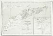
Maps of Oecusse
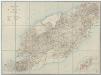
[Zonder aantekeningen], uit: Schetskaart van Timor (Nederlandsch gebied) / [door de] Topographische Inrichting, Batavia
1 : 250000 Annotatie: Gegevens verzameld over de periode/Data collected over the period: 1919; Op de kaart wordt de administratieve indeling t/m landschappen aangegeven; Bijgewerkt t/m Februari 1919; Met opgave van de bestuurlijke indeling; Annotatie geografische gegevens: Schaalstok van 25 K.M. (=10 cm); Legenda Topografische Inrichting, Batavia; Topografische inrichting in Nederlandsch-Indië/1Batavia Batavia : Topographische Inrichting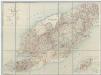
[Met aantekeningen], uit: Schetskaart van Timor (Nederlandsch gebied) / [door de] Topographische Inrichting, Batavia
1 : 250000 Annotatie: Gegevens verzameld over de periode/Data collected over the period: 1919; Op de kaart wordt de administratieve indeling t/m landschappen aangegeven; Bijgewerkt t/m Februari 1919; Met opgave van de bestuurlijke indeling; Annotatie geografische gegevens: Schaalstok van 25 K.M. (=10 cm); Legenda Topografische Inrichting, Batavia; Topografische inrichting in Nederlandsch-Indië/1Batavia Batavia : Topographische Inrichting
Overzichtskaart van Timor : Nederlandsch gebied = General map of Timor (Netherlands territory) / Topografische Dienst
Topografische Dienst Batavia Batavia : Reproductiebedrijf Topografische Dienst
Schetskaart van Timor (Nederlandsch gebied) / Topographische Inrichting Batavia 1920 ; bijgewerkt t[ot en] m[et] februari 1919
Topographische Inrichting Batavia Batavia : Topographische Inrichting
Kaart van een gedeelte van het eiland Timor met de grenzen op dat eiland van het Nederlandsch en Portugeesch gebied volgens het tractaat van 1 october 1904
Koninklijk Nederlandsch Aardrijkskundig Genootschap Amsterdam Leiden : Boekhandel en Drukkerij voorheen E.J. Brill
Schetskaart van het Landschap Beloe / P.J. Spruijt

Schetskaart van Timoer-Koepang en omgeving
[S.l. : s.n.]
Res. Timor en Onderh., Blad 87/XLVIII [235], uit: Res. Timor en onderh
1 : 100000 Annotatie: Aanwezig: 3 bladen West-Timor en 4 bladen Roti; Annotatie geografische gegevens: Geografische plaatsbepaling t.o.v. de 0-meridiaan van Batavia; Op elk blad een kaartje met de administratieve indeling tot het niveau van landschappen Batavia : Topografische dienst
Res. Timor en Onderh., Blad XLIX/L-87 [236-237], uit: Res. Timor en onderh
1 : 100000 Annotatie: Aanwezig: 3 bladen West-Timor en 4 bladen Roti; Annotatie geografische gegevens: Geografische plaatsbepaling t.o.v. de 0-meridiaan van Batavia; Op elk blad een kaartje met de administratieve indeling tot het niveau van landschappen Batavia : Topografische dienst
Carte de la limite entre O'Kussi-Ambenu (Portugal) et les possesions néerlandaises dans l'ile de Timor : selon l'article 3 sub. 10 de la convention du 1er Octobre 1904 / Door den Kapitein der Infanterie V.J. van Marle

Schetskaart van Nederlandsch Timor en omliggende eilanden / Topographische Inrichting
Topografische Inrichting Batavia Batavia : Topographische Inrichting
Dilly / Survey of India
Survey of India [S.l.] : Survey of India
Carte de la limite entre les possessions des Pays-Bas dans la partie occidentale et du Portugal dans la partie orientale de L'Ille de Timor
[Batavia : Algemeene Landsdrukkerij]
Carte de la limite entre les possessions des Pays-Bas dans la partie occidentale et du Portugal dans la partie orientale de L'Ille de Timor
['s-Gravenhage : Algemeene Landsdrukkerij]
Carte de la limite entre O'Kussi-Ambenu (Portugal) et les possesions néerlandaises dan l'ile de Timor
[Batavia : Algemeene Landsdrukkerij]
Carta da fronteira entre as possesões portuguezas e neerlandezas a meio da ilha de Timor : comprehendendo Maucatar segundo o tratado de 1859
Koepang : [s.n.]
Ilha de Timor / desenhada Antonio Aug. de Santos Victal
Dilly : [s.n.]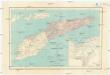
Carta da provincia de Timor
1 : 1000000 Timor (Indonésie) Ministerio das colonias
Kaart van het Eiland Timor / zamengesteld door G.H. Heymering ; lith[ographie] door C. Franz
Batavia : Lith[ographie] der Genie
Ilha de Timor / desenhada por Antonio Aug. de Santos Victal
[S.l. : Repartiçao das Obras Publicas Timor]
Ilha de Timor / desenhada por Antonio Aug. de Santos Victal
Dilly : [s.n.]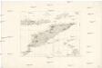
Essai sur la géographie de l'Île Timor
Havajské ostrovy Freycinet, L. de
Koepang / U.S. Army Map Service
U.S. Army Map Service Washington D.C. Washington D.C. : U.S. Army Map Service
Koepang / Topografische Dienst
Topografische Dienst Batavia Batavia : Reproductiebedrijf Topografische Dienst
Koepang / Topografische Dienst
Topografische Dienst Batavia Batavia : Reproductiebedrijf Topografische Dienst
Flores, Soemba, Timor
Carta da Provincia da Timor
1 : 1000000 Wall Map M. Diniz Institut Cartographique de Paris
Timor : carta topographica da regiao central a lesta da fronteira Luso - Hollandeza / pelo 1ÿê tenente da armada Gago Coutinho ; coordenada pelo tenente d'infanteria M. Luna
[S.l. : s.n.]
Timor : carta topographica da regiao central a lesta da fronteira Luso - Hollandeza / pelo 1ÿê tenente da armada Gago Coutinho ; coordenada pelo tenente d'infanteria M. Luna
Bat[avia] : Top[ographische] Inr[ichting]
![[Zonder aantekeningen], uit: Schetskaart van Timor (Nederlandsch gebied) / [door de] Topographische Inrichting, Batavia](https://images-2.georeferencer.com/images/iiif/172681312405/full/,300/0/native.jpg)

