Maps of Malay Archipelago

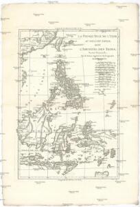
La presqu'isle de l'Indie au dela du Gange, avec l'archipel des Indes
1 : 12640000 Asie jihovýchodní Bonne, Rigobert André
Die Ostindischen Inseln
[S.l. : s.n.]
Asiatic Archipelago.
1 : 10771200 Letts, Son & Co.
Archipel Asiatique.
1 : 10000000 Vivien St Martin, L.
East Indies.
1 : 11000000 Colton, G.W.
Malay Archipelago.
1 : 11000000 Society for the Diffusion of Useful Knowledge (Great Britain)
East India Islands.
1 : 34000000 Fenner, Rest.

A new map of the East India Isles from the latest authorities
1 : 9000000 Cary, John, ca. 1754-1835 J. Cary
Carta di una parte dell'Asia e dell'Oceania ... per poter conoscere le colonie Europee, ed i punti, ove si trova stabilita la religion Cattolica in quei luoghi, con i viaggi che fece dall'anno 1841 fino al 1849 il capitano Don Carlo Cuarteron / presentata dal medesimo ... l'anno 1855
1 : 4000000 Carlo Cuarteron 1816-1880 [S.l. : Top. Inr.]
Nieuwe kaart van de Filippynsche, Ladrones, Moluccos of Specery Eilanden alsmede Celebes enz. / uitgegeven te Amsterdam door Isaak Tirion
Te Amsterdam : door Isaak Tirion
Indes IV.
1 : 10000000 Bonne, Rigobert, 1727-1794
Progressus numericus Catholicorum ab anno 1938 usque ad annum 1948, necnon distributio Catholicorum tempore dismembrationum anno 1938 et 1948, grafice exhibitur in Insulæ Borneo parte Indonesiana
1 : 16500000 [S.l. : Vicario Apostolico de Pontianak]
Kaart van Nederlands Oostindische bezittingen / uitgegeven door Maatschappij tot het Nut van 't Algemeen ; Dl. Veelwaard Jr. del[ineavi]t et sculps[i]t
Maatschappij tot het Nut van 't Algemeen [S.l.] : Maatschappij tot het Nut van 't Algemeen
Kaart van Nederlands Oostindische bezittingen
1 : 7500000 Dl. Veelwaard Jr. del.t et sculps.t. uitgegeven door Maatschappij tot het Nut van 't Algemeen
[Recto], uit: Kaart van Ned. Oost-Indië : (tevens automobielkaart) / door P. Joh. Bettink en J. Krijgsman
1 : 4150000 titelvariant: Sleeswijk's kaart van Ned. Oost-Indië; Annotatie: Omslagtitel: Sleeswijk's kaart van Ned. Oost-Indië Bettink, P. Joh.; Krijgsman, J. Bussum : Sleeswijk
Java in zijn natuurlijke en staatkundige gesteldheid / [C.M. Kan]
1 : 2000000 Annotatie: Uit: Kaart van den Nederlandsch-Indischen Archipel / bewerkt door C.M. Kan. - Amsterdam : Beijers, 1892 Kan, C. M. [Amsterdam : Beijers]
Carte des îles Philippines, Célébes et Moluques
1 : 3700000 dressée par M. Daussy d'après les travaux le plus récents gravé par Chassant ; écrit par J.M. Hacq. [Paris] : Dépot-général de la Marine
Islas Filipinas, 3a hoja / por el teniente coronel de ingenieros D. Francisco Coello ; las notas estadisticas e historicas han sido escritas por D. Pascual Madoz
1 : 1000000 1 full d'un mapa en tres fulls, b/n. Dins: Atlas de España y sus posesiones de ultramar Coello, Francisco ; Madoz, Pascual [Imprenta del Atlas de España]
No. 6. Distibucion de Temlores Signos.
1 : 6000000 U.S. Coast and Geodetic Survey
[Borneo, Celebes, Halmaheira, Ceram] / Top. Bureau v/d Gen. Staf
Topographisch Bureau Generale Staf Batavia Batavia : Top. Bureau v/d Gen. Staf
Kaart van Nederlandsch Oost-Indië op een schaal van 1:1.800.000 / naar de nieuwste bronnen bew. onder toezicht van I. Dornseiffen door E. de Geest
1 : 1800000 Annotatie geografische gegevens: Inzet: De Natoena-eilanden; Noordelijk gedeelte der Tidoengsche landen; De Taloer- of Salibao-Eilanden; Atjih, Babi en Nias; Nieuw-Guinea (Nederlandsch gedeelte) en nabijliggende eilanden. - 1:6.000.000 Isaac Dornseiffen 1818-1898; Evert de Geest 1838-? Amsterdam : Seyffardt
Blad VII Siding, uit: Residentie Wester-Afdeeling van Borneo / Topographisch Bureau
1 : 200000 titelvariant: Residentie Westerafdeeling van Borneo; Annotatie: Titelvariant: Residentie Westerafdeeling van Borneo; Voor aanwezige bladen zie overzichtsblad; Annotatie geografische gegevens: Opname: 1886-1895 Topographisch Bureau, Batavia Batavia : Topographisch Bureau
No. 5. Estaciones Meteorologico-Seismicas.
1 : 6000000 U.S. Coast and Geodetic Survey
[Islas filipinas - mapa etnografico]
Atlas de Filipinas Algué, P. José Government Printing Office
[Islas filipinas - mapa orografico]
Atlas de Filipinas Algué, P. José Government Printing Office
[Islas filipinas - estaciones meteorologico-seismicas]
Atlas de Filipinas Algué, P. José Government Printing Office
[Islas filipinas - distribution de temblores]
Atlas de Filipinas Algué, P. José Government Printing Office
[Islas filipinas - mapa general]
Atlas de Filipinas Algué, P. José Government Printing Office