Maps of Scandinavia

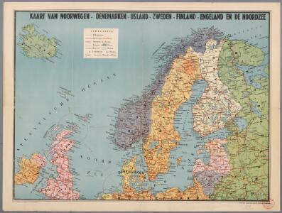
Kaart van Noorwegen, Denemarken, ijsland, Zweden, Finland, Engeland en de Noordzee / W. Seghers
1 : 4000000 Seghers, W. Antwerpen : Patria [etc.]
Schonlandia XIII Nova Tabula [Karte], in: Claud. Ptolemaeus. Geographia lat. cum mappis [...], S. 389.
1 Karte aus Atlas Münster, Sebastian [und Ptolemaeus, Claudius]
Schonlandia XIII Nova Tabula [Karte], in: Geographia universalis vetus et nova complectens Claudii Ptolemaei Alexandrini enarrationis libros VIII, S. 335.
1 Karte aus Atlas Münster, Sebastian [und Ptolemaeus, Claudius]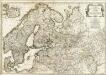
Europe 2.
1 : 2800000 Anville, Jean Baptiste Bourguignon d, 1697-1782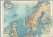
Northern Europe. Pergamon World Atlas.
1 : 5000000 Polish Army Topography Service
Dänemark, Island u Färöer, Schweden und Norwegen
Hand-Atlas über alle Theile der Erde nach dem neuesten Zustande und über das Weltgebäude Stieler, Adolf bei Justus Perthes
Dänemark, Jsland u. Färöer, Schweden und Norwegen
Stieler's Hand-Atlas Stieler, Adolf bei Justus Perthes
Europe (north)
1 : 6000000 Lizars, Daniel
Tabula Moderna Prussie Livonie Norbegie Et Gottie. [Karte], in: [Clavdii Ptholomei Cosmographi ...], S. 263.
1 Karte aus Atlas Nicolaus Germanus [und Ptolemaeus, Claudius]
Spannungen in Nordeuropa
1 : 5000000 Evropa severní List & von Bressensdorf
[Ethnographische Karte von Europa]
Zweiter Band, enthaltend in vier Abtheilungen die Vertheilung der Organismen: 5. Pflanzen-Geographie, 6. Thier-Geographie, 7. Anthropographie, 8. Ethnographie Humboldt, Alexander von Verlag von Justus Perthes
Schweden, Norwegen, Daenemark.
1 : 4000000 Ziegler, J. M.
Vorstellvng der Sonnen- oder Erd, Finsternis den 25. Jul. 1748
Mollova mapová sbírka Lowitz, Georg Moriz Dorn, Sebastian Homann, Johann Baptista - dědici
Länder der Nord- und Ostsee
1 : 10000000 Nordeuropa
Sweden, Denmark, Norway and Finland.
1 : 6600000 Carey, Mathew
Schweden Daenemarck u. Norwegen
Dánsko Mollo, Tranquillo Tranquillo Mollo
Finnland und Skandinavien
1 : 4000000 Finsko Velhagen & Klasing
Charte von Schweden und Norwegen
1 : 3700000
Schweden und Norwegen
1 : 11400000 Dánsko
Northern States.
1 : 4400000 Robert Laurie & James Whittle

Karte von Europa, 1
4 Blätter : 53 x 70 cm Verlag der Königlich-Preussischen Academie-Kunst- und Buchhandlung
Nordeuropa 1871
Nordeuropa Kunz, Andreas ; Röss, Wolf ; Johnen, Bettina ; Moeschl, Joachim Robert
Der Westhandel Nordosteuropas in der Frühen Neuzeit
Europa (Nordost) Handel
Tabula exactissima Regnorum Sueciae et Norvegiae, nec non Maris Universi Orientalis [...] [Karte], in: Novus atlas absolutissimus, Bd. 1, S. 45.
1 Karte aus Atlas Janssonius Offizin
Sweden, Denmark, Norway and Finland.
1 : 6336000 Carey, Mathew
Sweden, Denmark, Norway and Finland.
1 : 8236800 Carey, Mathew
Sweden, Denmark, Norway and Finland.
1 : 8236800 Carey, Mathew
Nordeuropa 1905
Nordeuropa Kunz, Andreas ; Röss, Wolf ; Johnen, Bettina ; Moeschl, Joachim Robert