Maps of Scandinavia

Charte von Schweden und Norwegen
1 : 3700000
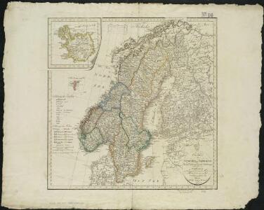
Sweden, Denmark, Norway and Finland.
1 : 6600000 Carey, Mathew
Kaart van Noorwegen, Denemarken, ijsland, Zweden, Finland, Engeland en de Noordzee / W. Seghers
1 : 4000000 Seghers, W. Antwerpen : Patria [etc.]
Schweden Daenemarck u. Norwegen
Dánsko Mollo, Tranquillo Tranquillo Mollo
Schonlandia XIII Nova Tabula [Karte], in: Geographia universalis vetus et nova complectens Claudii Ptolemaei Alexandrini enarrationis libros VIII, S. 335.
1 Karte aus Atlas Münster, Sebastian [und Ptolemaeus, Claudius]
Les couronnes du Nord comprenant les royaumes de Suede Danemarck et Norwege
1 Karte : Kupferdruck ; 46 x 64 cm Janvier; Lattré; Choffard chés Lattré graveur rue Saint Jacques au coin de celle de la parcheminerie à la ville de Bordeaux
Sweden, Denmark, Norway and Finland.
1 : 6336000 Carey, Mathew
Sweden, Denmark, Norway and Finland.
1 : 8236800 Carey, Mathew
Sweden, Denmark, Norway and Finland.
1 : 8236800 Carey, Mathew
Spesielle kart 77: Bathymetrical and hypsometrical map of Norway
1 : 2400000 Kristiania Lithografiske Aktiebolag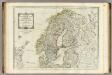
A new map of the Northern States containing the Kingdoms of Sweden, Denmark, and Norway.
1 : 4400000 Kitchin, Thomas
Spannungen in Nordeuropa
1 : 5000000 Evropa severní List & von Bressensdorf
Spesielle kart 66-4: Kart udvisende de med bidrag af Statskassen understøttende Dampskibsrouter
1 : 2400000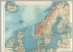
Northern Europe. Pergamon World Atlas.
1 : 5000000 Polish Army Topography Service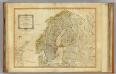
Northern States.
1 : 4400000 Robert Laurie & James Whittle
Nordeuropa 1922
Nordeuropa Kunz, Andreas ; Treiling, Thomas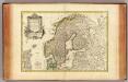
Suede, Danemarck et Norwege.
1 : 6900000 Janvier, Jean
Spesielle kart 66-5: Kart udvisende de med bidrag af Statskassen understøttende Dampskibsrouter
1 : 2400000
Schweden, Norwegen, Daenemark.
1 : 4000000 Ziegler, J. M.
Statistikk kart 19- Fremstilling af Norges Agerbrug. Udsæden af Korn i Tønder pr. 1000 maal ager
1 : 2400000
Statistikk 9- Norvege. Mouvement de la population
1 : 2400000
Spesielle kart 66-6: Kart udvisende de med bidrag af Statskassen understøttende Dampskibsrouter
1 : 2400000
Spesielle kart 129-3: Oversigtskart over fà ̧rste ordens trianguleringen og præcisionsnivellementet
1 : 2800000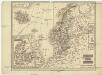
Schweden und Norwegen
1 : 11400000 Dánsko
Finnland und Skandinavien
1 : 4000000 Finsko Velhagen & Klasing
Schweden und Norwegen oder Scandinavische Halbinsel Königr. Daenemark
Geographischer Atlas über alle Theile der Erde Ziegler, Jakob Melchior Verlag von Joh. Wurster um Comp.
Statistikk kart 20- Fremstilling af den Norske Fædrift. Hesten. Dyrenes antal pr. 1000 Maal afhøstet areal
1 : 2400000
Spesielle kart 72b: Kart over Valgmands- og Stortingsvalgene
1 : 2400000 K. Petersen Olaf Norli's forlag; Kristiania
Spesielle kart 62: Pflanzengeographisce Karte über das Königreich Norwegen
1 : 2000000