Maps of Scandinavia

Tabula Moderna Prussie Livonie Norbegie Et Gottie. [Karte], in: [Clavdii Ptholomei Cosmographi ...], S. 263.
1 Karte aus Atlas Nicolaus Germanus [und Ptolemaeus, Claudius]
Scandinavien und Polen, kirchlichen Eintheilung bis zur Reformation.
1 : 9400000 Spruner von Merz, Karl
Dänemark, Jsland u. Färöer, Schweden und Norwegen
Stieler's Hand-Atlas Stieler, Adolf bei Justus Perthes
Septentrionales Regiones XVIII. No. Tab. [Karte], in: Claud. Ptolemaeus. Geographia lat. cum mappis [...], S. 410.
1 Karte aus Atlas Münster, Sebastian [und Ptolemaeus, Claudius]
Dänemark, Island u Färöer, Schweden und Norwegen
Hand-Atlas über alle Theile der Erde nach dem neuesten Zustande und über das Weltgebäude Stieler, Adolf bei Justus Perthes
Tabula Moderna Norbegie Et Gottie. [Karte], in: Claudii Ptolemei viri Alexandrini mathematice discipline philosophi doctissimi geographie opus [...], S. 251.
1 Karte aus Atlas Waldseemüller, Martin [und Ptolemaeus, Claudius] Übelin, Georg
Swedland and Norway.
from A new systeme of the mathematicks: containing I. Arithmetick, as well natural and decimal, as in species, or the principles of algebra. II. Practical geometry, together with the first six books of Euclid's Elements, as also the eleventh and twelfth, symbo
Neueste Post und General Karte von Europa mit der neuesten Länder Abtheilung des letzten Frieden Tractats
1 : 38230000 Evropa Arrowsmith, Aaron Artaria und Compagnie
Neueste Post und General Karte von Europa mit der neuesten Länder Abtheilung des letzten Friedens Tractate
1 : 3900000 Evropa Arrowsmith, John Artaria und Compagnie
[Evropa]
1 : 12500000 Evropa
Septentrionalium Regionum Descrip. [Karte], in: Theatrum orbis terrarum, S. 286.
1 Karte aus Atlas Ortelius, Abraham
[Evropa]
1 : 12500000 Evropa
Europe (north)
1 : 4800000 Robert Laurie & James Whittle
Physische und politische Carte von Europa
1 : 15000000 Evropa Desjardin, C. H. F. Müller
Karte von Europa nach den zuverlässigsten Hülfsmitteln und seiner neuesten politischen Eintheilung gezeichnet
1 : 10000000 Evropa Joh. Walch
Charte von Europa nach astronomischen Bestimmungen der vornehmsten Orte und damaligen Bestande der Staaten
1 : 15000000 Evropa Güfsefeld, F. L. bey Homans Erben, jetzt Christoph Fembo
Karte von Europa
1 : 12000000 Evropa Anville, Jean-Baptiste Bourguinon d' hrsg. Franz Joh. Jos. von Reilly
Karte von Europa
1 : 12300000 Evropa Reilly, Franz Johann Josef von Anville, Jean-Baptiste Bourguinon d' zu finden im von Reilly'schen Landkarten und Kunstwerke Verschleiss Komptoir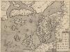
Septentrionallium Regionum Descrip. [Karte], in: Theatrum orbis terrarum, S. 381.
1 Karte aus Atlas Ortelius, Abraham Vrients, Jan Baptista
North Sea, Baltic cables, wireless stations.
1 : 12500000 Philip, George
Evropa poly glotta linguarum genealogiam exhibens
1 Karte : Kupferdruck ; 16 x 20 cm Hensel Homännische Erben
Vorstellvng der Sonnen- oder Erd, Finsternis den 25. Jul. 1748
Mollova mapová sbírka Lowitz, Georg Moriz Dorn, Sebastian Homann, Johann Baptista - dědici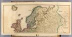
Europe (north)
1 : 6000000 Lizars, Daniel
Kaart van Noorwegen, Denemarken, ijsland, Zweden, Finland, Engeland en de Noordzee / W. Seghers
1 : 4000000 Seghers, W. Antwerpen : Patria [etc.]
Schonlandia XIII Nova Tabula [Karte], in: Claud. Ptolemaeus. Geographia lat. cum mappis [...], S. 389.
1 Karte aus Atlas Münster, Sebastian [und Ptolemaeus, Claudius]
Septentrionalivm regionvm descrip
1 : 11050000 Evropa severozápadní
Evropa XIX. století: od vídeňského kongresu r. 1815, do rozhodnutí na frontách světové války r. 1918
Kašpar, Jan
Länder der Nord- und Ostsee
1 : 10000000 Nordeuropa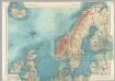
Northern Europe. Pergamon World Atlas.
1 : 5000000 Polish Army Topography Service
![Tabula Moderna Prussie Livonie Norbegie Et Gottie. [Karte], in: [Clavdii Ptholomei Cosmographi ...], S. 263.](https://images-2.georeferencer.com/images/iiif/896369432991/full/,300/0/native.jpg)

